Madera Acres, California

Last updated
Madera Acres
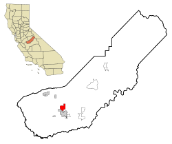
Madera County California Incorporated and Unincorporated areas Madera Acres Highlighted.svg
Location in Madera County and the state of California
Usa edcp location map.svg
Red pog.svg
Madera Acres
Location in the United States
Coordinates: 37°01′09″N120°04′01″W / 37.01917°N 120.06694°W / 37.01917; -120.06694 Coordinates: 37°01′09″N120°04′01″W / 37.01917°N 120.06694°W / 37.01917; -120.06694
Country Flag of the United States.svg  United States
State Flag of California.svg  California
County Madera
Area
[1]
  Total7.28 sq mi (18.86 km2)
  Land7.28 sq mi (18.86 km2)
  Water0 sq mi (0 km2)  0%
Elevation
[2]
292 ft (89 m)
Population
 (2020) [3]
  Total9,162
  Density1,300/sq mi (490/km2)
Time zone UTC-8 (Pacific (PST))
  Summer (DST) UTC-7 (PDT)
ZIP code
93638 (Madera)
Area code(s) 559
FIPS code 06-45050
GNIS feature ID1867039

Madera Acres (Madera, Spanish for "wood") is a census-designated place (CDP) in Madera County, California, United States. It is part of the Madera Metropolitan Statistical Area. The population was 9,162 at the 2020 census, virtually unchanged from 2010.

Contents

Geography

Madera Acres is located at 37°01′09″N120°04′01″W / 37.01917°N 120.06694°W / 37.01917; -120.06694 . [2] It is bordered to the south by the city of Madera, the county seat.

According to the United States Census Bureau, the CDP has a total area of 7.3 square miles (19 km2), all of it land. [1]

Demographics

2010

Historical population
CensusPop.
2000 7,741
2010 9,16318.4%
2020 9,1620.0%
U.S. Decennial Census [4]

The 2010 United States Census [5] reported that Madera Acres had a population of 9,163. The population density was 1,259.0 inhabitants per square mile (486.1/km2). The racial makeup of Madera Acres was 5,838 (63.7%) White, 241 (2.6%) African American, 161 (1.8%) Native American, 114 (1.2%) Asian, 5 (0.1%) Pacific Islander, 2,448 (26.7%) from other races, and 356 (3.9%) from two or more races. Hispanic or Latino of any race were 5,985 persons (65.3%).

The Census reported that 9,154 people (99.9% of the population) lived in households, 9 (0.1%) lived in non-institutionalized group quarters, and 0 (0%) were institutionalized.

There were 2,411 households, out of which 1,246 (51.7%) had children under the age of 18 living in them, 1,668 (69.2%) were opposite-sex married couples living together, 273 (11.3%) had a female householder with no husband present, 192 (8.0%) had a male householder with no wife present. There were 136 (5.6%) unmarried opposite-sex partnerships, and 14 (0.6%) same-sex married couples or partnerships. 204 households (8.5%) were made up of individuals, and 82 (3.4%) had someone living alone who was 65 years of age or older. The average household size was 3.80. There were 2,133 families (88.5% of all households); the average family size was 3.95.

The population was spread out, with 2,906 people (31.7%) under the age of 18, 934 people (10.2%) aged 18 to 24, 2,265 people (24.7%) aged 25 to 44, 2,279 people (24.9%) aged 45 to 64, and 779 people (8.5%) who were 65 years of age or older. The median age was 31.0 years. For every 100 females, there were 101.1 males. For every 100 females age 18 and over, there were 101.4 males.

There were 2,540 housing units at an average density of 349.0 per square mile (134.7/km2), of which 1,967 (81.6%) were owner-occupied, and 444 (18.4%) were occupied by renters. The homeowner vacancy rate was 1.9%; the rental vacancy rate was 5.5%. 7,149 people (78.0% of the population) lived in owner-occupied housing units and 2,005 people (21.9%) lived in rental housing units.
2000

As of the census [6] of 2000, there were 7,741 people, 2,122 households, and 1,894 families residing in the CDP. The population density was 1,018.3 inhabitants per square mile (393.2/km2). There were 2,188 housing units at an average density of 287.8 per square mile (111.1/km2). The racial makeup of the CDP was 60.16% White, 3.57% African American, 2.17% Native American, 1.55% Asian, 0.05% Pacific Islander, 27.44% from other races, and 5.06% from two or more races. Hispanic or Latino of any race were 50.88% of the population.

There were 2,122 households, out of which 50.6% had children under the age of 18 living with them, 73.5% were married couples living together, 10.1% had a female householder with no husband present, and 10.7% were non-families. 7.8% of all households were made up of individuals, and 2.7% had someone living alone who was 65 years of age or older. The average household size was 3.62 and the average family size was 3.76.

In the CDP, the population was spread out, with 34.7% under the age of 18, 9.7% from 18 to 24, 27.3% from 25 to 44, 21.9% from 45 to 64, and 6.4% who were 65 years of age or older. The median age was 30 years. For every 100 females, there were 105.0 males. For every 100 females age 18 and over, there were 102.7 males.

The median income for a household in the CDP was $45,438, and the median income for a family was $45,633. Males had a median income of $34,731 versus $22,734 for females. The per capita income for the CDP was $15,003. About 7.4% of families and 10.4% of the population were below the poverty line, including 12.0% of those under age 18 and none of those age 65 or over.

Government

In the California State Legislature, Madera Acres is in the 12th Senate District , represented by Democrat Anna Caballero, and the 5th Assembly District , represented by Republican Frank Bigelow. [7]

In the United States House of Representatives, Madera Acres is in California's 16th congressional district , represented by Democrat Jim Costa. [8]

Related Research Articles

Fairview, California CDP in California, United States

Fairview is a census-designated place (CDP) in Alameda County, California, United States. It borders on the city of Hayward and the census-designated place of Castro Valley. The population was 11,341 at the 2020 census.

Del Rey, California Census-designated place in California, United States

Del Rey is a census-designated place (CDP) in Fresno County, California, United States. The population was 1,639 at the 2010 census, up from 950 at the 2000 census. Del Rey is located 3.5 miles (5.6 km) south-southwest of Sanger, at an elevation of 344.

Friant, California Census-designated place in California, United States

Friant is a census-designated place (CDP) in Fresno County, California, United States. The population was 549 at the 2010 census, down from 778 at the 2000 census. Friant is located 11.5 miles (19 km) north of Clovis, at an elevation of 344 feet.

Raisin City, California Census-designated place in California, United States

Raisin City is a census-designated place (CDP) in Fresno County, California, United States. The population was 380 at the 2010 census, up from 165 at the 2000 census. Raisin City is located 13 miles (21 km) south-southwest of downtown Fresno, at an elevation of 236 feet.

Dustin Acres, California Census-designated place in California, United States

Dustin Acres is a census-designated place (CDP) in Kern County, California, United States. Dustin Acres is located 6.5 miles (10 km) north-northeast of Taft, at an elevation of 384 feet (117 m). The population was 652 at the 2010 census, up from 585 at the 2000 census.

Valley Acres, California Census-designated place in California, United States

Valley Acres is a census-designated place (CDP) in Kern County, California, United States. Valley Acres is located 5.2 miles (8.4 km) north-northeast of Taft, at an elevation of 420 feet (128.02 m). The population was 527 at the 2010 census, up from 512 at the 2000 census.

Bonadelle Ranchos-Madera Ranchos, California Former census-designated place in California, United States

Bonadelle Ranchos and Madera Ranchos are a pair of communities in Madera County, California, United States. They are part of the Madera–Chowchilla Metropolitan Statistical Area. Prior to 2020, the communities were part of the Bonadelle Ranchos-Madera Ranchos Census Designated Place, with a population of 8,569 at the 2010 census. For the 2020 census, the area was split into two CDPs, Bonadelle Ranchos and Madera Ranchos.

Oakhurst, California Census-designated place in California, United States

Oakhurst is a census-designated place (CDP) in Madera County, California, United States, 14 miles (23 km) south of the entrance to Yosemite National Park, in the foothills of the Sierra Nevada. At the 2020 census, the population was 5,945, up from 2,829 at the 2010 census. It is part of the Madera metropolitan statistical area.

Parksdale, California Census-designated place in California, United States

Parksdale is a census-designated place (CDP) in Madera County, California, United States. It is part of the Madera Metropolitan Statistical Area. The population was 3,234 at the 2020 census, up from 2,621 in 2010.

Parkwood, California Census-designated place in California, United States

Parkwood is a census-designated place (CDP) in Madera County, California, United States. It is part of the Madera Metropolitan Statistical Area. The population was 2,307 at the 2020 census.

C-Road, California Census-designated place in California, United States

C-Road is a census-designated place (CDP) in Plumas County, California, United States. The population was 150 at the 2010 census, down from 152 at the 2000 census.

Spring Garden, California Census-designated place in California, United States

Spring Garden is a census-designated place (CDP) in Plumas County, California, United States. The population was 16 at the 2010 census, down from 55 at the 2000 census.

Taylorsville, California Census-designated place in California, United States

Taylorsville is a census-designated place (CDP) in Plumas County, California, United States. The population was 150 at the 2010 census, down from 154 at the 2000 census. The annual Stone Ranch Reunion is held in Taylorsville.

Morongo Valley, California Census-designated place in California, United States

Morongo Valley is a census-designated place (CDP) on State Route 62 in San Bernardino County, California, United States. The population was 3,552 at the 2010 census, up from 1,929 at the 2000 census. The town is bordered by Yucca Valley, California.

Mountain View Acres, California Census-designated place in California, United States

Mountain View Acres is a census-designated place (CDP) in the Victor Valley of the Mojave Desert, within San Bernardino County, California.

Garden Acres, California Census-designated place in California, United States

Garden Acres is a census-designated place (CDP) in San Joaquin County, California, United States. The population was 10,648 at the 2010 census, up from 9,747 at the 2000 census. It is the most populous CDP in San Joaquin County.

Ashford, Washington CDP in Washington, United States

Ashford is a census-designated place (CDP) mostly within Pierce County, Washington, United States. Its population was 217 as of the 2010 census. The town is west of the main entrance to Mount Rainier National Park. Surrounding mountains and the narrow Nisqually River valley are heavily forested. Some of Ashford is across the Nisqually River in Lewis County.

Ahwahnee, California Census-designated place in California, United States

Ahwahnee is a census-designated place in Madera County, California, United States. It is located 5.25 miles (8.4 km) west of Yosemite Forks, at an elevation of 2,326 feet (709 m). The population was 2,296 at the 2020 census.

Rolling Hills is an unincorporated community and census-designated place (CDP) in Madera County, California, United States, north of Fresno on State Route 41. It lies at an elevation of 371 feet (113 m). The population was 793 at the 2020 census.

Yosemite Lakes Park, California Census-designated place in California, United States

Yosemite Lakes Park is an unincorporated community in Madera County, California. It lies at an elevation of 1,230 feet (370 m). As a census-designated place (CDP) it is known as Yosemite Lakes. It is part of the Madera Metropolitan Statistical Area. The population was 5,022 at the 2020 census.

References

  1. 1 2 "2021 U.S. Gazetteer Files: California". United States Census Bureau. Retrieved June 27, 2022.
  2. 1 2 U.S. Geological Survey Geographic Names Information System: Madera Acres, California
  3. "P1. Race – Madera Acres CDP, California: 2020 DEC Redistricting Data (PL 94-171)". U.S. Census Bureau. Retrieved June 27, 2022.
  4. "Census of Population and Housing". Census.gov. Retrieved June 4, 2016.
  5. "2010 Census Interactive Population Search: CA - Madera Acres CDP". U.S. Census Bureau. Archived from the original on July 15, 2014. Retrieved July 12, 2014.
  6. "U.S. Census website". United States Census Bureau . Retrieved 2008-01-31.
  7. "Statewide Database". Regents of the University of California. Archived from the original on February 1, 2015. Retrieved March 26, 2015.
  8. "California's 16th Congressional District - Representatives & District Map". Civic Impulse, LLC.