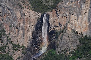
Bridalveil Fall is one of the most prominent waterfalls in the Yosemite Valley in California, Yosemite National Park. The waterfall is 188 metres (617 ft) in height and flows year round.

The Dana Meadows can be found at the eastern entrance to Yosemite National Park, at the foot of Mount Dana, not far from Tuolumne Meadows and the Tioga Pass entrance station.

The Merced River, in the central part of the U.S. state of California, is a 145-mile (233 km)-long tributary of the San Joaquin River flowing from the Sierra Nevada into the San Joaquin Valley. It is most well known for its swift and steep course through the southern part of Yosemite National Park, where it is the primary watercourse flowing through Yosemite Valley. The river's character changes dramatically once it reaches the plains of the agricultural San Joaquin Valley, where it becomes a slow-moving meandering stream.

The Tuolumne River flows for 149 miles (240 km) through Central California, from the high Sierra Nevada to join the San Joaquin River in the Central Valley. Originating at over 8,000 feet (2,400 m) above sea level in Yosemite National Park, the Tuolumne drains a rugged watershed of 1,958 square miles (5,070 km2), carving a series of canyons through the western slope of the Sierra. While the upper Tuolumne is a fast-flowing mountain stream, the lower river crosses a broad, fertile and extensively cultivated alluvial plain. Like most other central California rivers, the Tuolumne is dammed multiple times for irrigation and the generation of hydroelectricity.

Wawona is a census-designated place in Mariposa County, California. It is located 18 miles (29 km) east of Mariposa, at an elevation of 3999 feet. The population was 169 at the 2010 census.

Sierra National Forest is a U.S. National Forest located on the western slope of central Sierra Nevada in Central California and bounded on the northwest by Yosemite National Park and the south by Kings Canyon National Park. The forest is known for its mountain scenery and natural resources. Forest headquarters are located in Clovis, California. There are local ranger district offices in North Fork and Prather.

Yosemite Village is an unincorporated community in Mariposa County, California. It is located 44 miles (71 km) northeast of Mariposa, at an elevation of 3996 feet.

Mount Ansel Adams is a peak in the Sierra Nevada of California. At an elevation of 11,766 ft. the summit is in Yosemite National Park near the park's eastern boundary. It lies 0.8 miles (1.3 km) northeast of Foerster Peak and 1.3 miles (2.1 km) west-southwest of Electra Peak at the head of the Lyell Fork of the Merced River. It was named in 1985 for Ansel Adams, the preeminent landscape photographer, conservationist, and member of the Board of Directors of the Sierra Club, a role he maintained for 37 years.
Bishop Creek is a 10.1-mile-long (16.3 km) stream in Inyo County, California. It is the largest tributary of the Owens River. It has five hydroelectric plants owned by Southern California Edison, Bishop Creek #2–6. Bishop Creek #1 was never completed. Parts of the creek run through pipelines, or penstocks, to increase output at the power plants.

Cherry Creek is a large, swift-flowing stream in the Sierra Nevada mountain range, and is the largest tributary of the Tuolumne River. The creek is 40 miles (64 km) long measured to its farthest headwaters; the main stem itself is 26 miles (42 km) long, draining a watershed of 234 square miles (610 km2) in the Stanislaus National Forest. Part of the drainage also extends into the northwest corner of Yosemite National Park.

The Plains and Sierra Miwok were once the largest group of Native American Miwok people, indigenous to California. Their homeland included regions of the Sacramento Valley, San Joaquin Valley, and the Sierra Nevada.

Sugar Pine is an unincorporated community in Madera County, California. It is located 5 miles (8 km) north of Yosemite Forks, at an elevation of 4236 feet. It is located 1 mile east of California State Route 41, between Oakhurst, California and the South Entrance of Yosemite National Park.
Merced Falls is an unincorporated community in Merced County, California. It is located on the north bank of the Merced River 6 miles (9.7 km) east of Snelling, at an elevation of 348 feet . Merced Falls was named for a set of rapids on the Merced River.
The Pines is an unincorporated community in Madera County, California. It is located on the northeast shore of Bass Lake 5.25 miles (8.4 km) southeast of Yosemite Forks, at an elevation of 3435 feet.

The South Fork Merced River is the largest tributary of the Merced River. Most of the river flows within Yosemite National Park in the Sierra Nevada of California. The river is 43 miles (69 km) long, and its drainage basin covers about 240 square miles (620 km2), of which 109 square miles (280 km2) are in the national park. The average flow at the mouth is 356 cubic feet per second (10.1 m3/s).

The South Fork Kings River is a 44.1-mile (71.0 km) tributary of the Kings River in the Sierra Nevada of Fresno County, California. The river forms part of Kings Canyon, the namesake of Kings Canyon National Park and one of the deepest canyons in North America with a maximum relief of 8,200 feet (2,500 m) from rim to river.
Ackerson Creek is a stream in Tuolumne County, California, in the United States. It is a tributary of the South Fork Tuolumne River.
Alder Creek is a stream in Mariposa County, California, in the United States. It is a tributary of the South Fork Merced River.
Bishop Creek is a stream in Yosemite National Park, United States. It is a tributary of the South Fork Merced River.

Bubbs Creek is a 16.4-mile (26.4 km)-long tributary of the South Fork Kings River in the Sierra Nevada of California, within Kings Canyon National Park.


