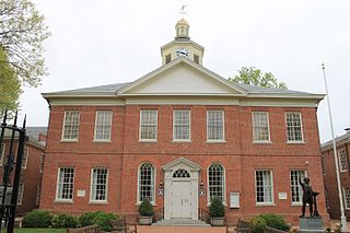
Talbot County is a county located in the heart of the Eastern Shore of Maryland in the U.S. state of Maryland. As of the 2010 census, the population was 37,782. Its county seat is Easton. The county was named for Lady Grace Talbot, the wife of Sir Robert Talbot, an Anglo-Irish statesman, and the sister of Lord Baltimore.

Neath Port Talbot is a county borough and one of the unitary authority areas of Wales. Neath Port Talbot is the eighth most populous local authority area in Wales and the third most populous county borough. The actual population taken at the 2011 census was 139,812. The coastal areas are mainly English-speaking, however there are many Welsh-speaking communities in the Valleys to the north of the borough.

Talbot School of Theology is an evangelical theological seminary of Biola University located near Los Angeles. Talbot is one of the seven schools that comprise Biola University, located in La Mirada, California. The school is interdenominational and theologically conservative in its theological positions.
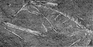
Podokesaurus was a small carnivorous dinosaur that lived during the Pliensbachian–Toarcian stages of the Early Jurassic Period, and as such is one of the earliest known dinosaurs to inhabit the eastern United States.

Merrimac is an unincorporated community in Butte County, California located along Oroville-Quincy Road about 2.1 miles (3.4 km) south of the Plumas County line. It lies at an elevation of 3999 feet. While the location is shown as official in the National Geographic Names Database, it is not known if locals use this name to describe the place today. Nearby is Rogers Cow Camp, a campground in Lassen National Forest. The USGS feature ID for this populated place is 1659117. The US Postal Service does not show a ZIP Code for this community. The location is within area code 530.

Guy W. Talbot State Park is a state park in the Columbia River Gorge, near Troutdale, Oregon, United States. Although the main feature of the park is Latourell Falls, the parkland stretches west to the Crown Point State Scenic Corridor. Here the Historic Columbia River Highway descends from Crown Point via the Figure-Eight Loops, a series of horseshoe curves that "develop distance" and thus keep the grade to a minimum.

Connie Victoria Elizabeth Talbot is an English singer. In 2007, she reached the final of the first series of Britain's Got Talent. She then signed with Rainbow Recording Company and released her debut album Over the Rainbow on 26 November 2007, which has sold over 250,000 copies worldwide and reached number one in three countries.

George W. Joseph State Natural Area is a natural area in the U.S. state of Oregon. It is located near the city of Troutdale between Latourell Falls and Guy W. Talbot State Park, and is accessible from both.
Actis is an unincorporated community in Kern County, California. It is located 6.5 miles (10 km) north of Rosamond, at an elevation of 2,562 feet (781 m). It is situated between Mojave and Rosamond at Backus Road and California State Route 14.
Alameda is an unincorporated community in Kern County, California. It is located 9 miles (14 km) south of Bakersfield, at an elevation of 331 feet (101 m).

Armistead is an unincorporated community in Kern County, California. It is located 9 miles (14 km) southwest of Inyokern, at an elevation of 3,068 feet (935 m). Armistead's ZIP Code is 93527.
Cameron is an unincorporated community in the Tehachapi Mountains, in Kern County, California. It is located on the Union Pacific Railroad 9 miles (14 km) east-southeast of Tehachapi, at an elevation of 3,802 feet (1,159 m).
Eric is a settlement in Kern County, California with a population of 14, as of the 2012 census. It is located on the railroad 7 miles (11 km) east of Tehachapi, at an elevation of 3924 feet.
Harts Place is an unincorporated community in Kern County, California.

Indian Wells is an unincorporated community in Kern County, California.
Lakeview is an unincorporated community in Kern County, California. It is located 8.5 miles (14 km) west-northwest of Mettler, at an elevation of 374 feet (114 m).
Ricardo is an unincorporated community in Kern County, California.
Spicer City is an unincorporated community in Kern County, California. It is located 9 miles (14 km) south-southeast of Lost Hills, at an elevation of 246 feet (75 m).
Glenblair is an unincorporated community in Mendocino County, California. It is located 15 miles (24 km) north-northwest of Comptche, at an elevation of 207 feet.

Talbot is an unincorporated community in Menominee County, in the U.S. state of Michigan.

