
Sutter's Fort was a 19th-century agricultural and trade colony in the Mexican Alta California province. Established in 1839, the site of the fort was originally called New Helvetia by its builder John Sutter, though construction of the fort proper would not begin until 1841. The fort was the first non-indigenous community in the California Central Valley. The fort is famous for its association with the Donner Party, the California Gold Rush, and the formation of the city of Sacramento, surrounding the fort. It is notable for its proximity to the end of the California Trail and Siskiyou Trails, which it served as a waystation.
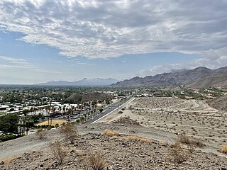
Rancho Mirage is a city in Riverside County, California, United States. The population was 16,999 at the 2020 census, down from 17,218 at the 2010 census, but the seasonal (part-time) population can exceed 20,000. Incorporated in 1973 and located between Cathedral City and Palm Desert, it is one of the nine cities of the Coachella Valley.

The Mojave River is an intermittent river in the eastern San Bernardino Mountains and the Mojave Desert in San Bernardino County, California, United States. Most of its flow is underground, while its surface channels remain dry most of the time, except for the headwaters and several bedrock gorges in the lower reaches.

The Fort Mohave Indian Reservation is an Indian reservation along the Colorado River, currently encompassing 23,669 acres (95.79 km2) in Arizona, 12,633 acres (51.12 km2) in California, and 5,582 acres (22.59 km2) in Nevada. The reservation is home to approximately 1,100 members of the federally recognized Fort Mojave Indian Tribe of Arizona, California, and Nevada, a federally recognized tribe of Mohave people.
An estate is a large parcel of land under single ownership, which would historically generate income for its owner.

The California Trail was an emigrant trail of about 1,600 mi (2,600 km) across the western half of the North American continent from Missouri River towns to what is now the state of California. After it was established, the first half of the California Trail followed the same corridor of networked river valley trails as the Oregon Trail and the Mormon Trail, namely the valleys of the Platte, North Platte, and Sweetwater rivers to Wyoming. The trail has several splits and cutoffs for alternative routes around major landforms and to different destinations, with a combined length of over 5,000 mi (8,000 km).

Palmerstown is a civil parish and suburb in western Dublin on the banks of the River Liffey. It forms part of the South Dublin local authority and the Dublin Mid-West parliamentary constituency. The area is bordered to the north by the River Liffey and the Strawberry Beds, to the west by Lucan, to the south-west by Clondalkin, to the south by Ballyfermot and to the east by the village of Chapelizod. Palmerstown village is situated near the Liffey Valley Shopping Centre. The area is situated near the major junction of the M50 motorway and the N4. It lies approximately 7 km west of O'Connell Street in Dublin city centre. The Old Lucan Road, once the main route from the city to the west, passes through the centre of Palmerstown village.
Couva is an urban town in west-central Trinidad, south of Port of Spain and Chaguanas and north of San Fernando and Point Fortin. It is the capital and main urban centre of Couva–Tabaquite–Talparo, and the Greater Couva area includes the Point Lisas industrial estate and the port of Point Lisas. It is one of the fastest-growing towns in the country. Couva's southern boundary is at the village of California and Point Lisas, and to the north Couva stretches to McBean. To the east of Couva is Preysal. To the west of Couva is the road to Waterloo and Carli Bay, which are located on the Gulf of Paria. Couva was part of the Caroni County. Couva is considered a major power base for the United National Congress, whose headquarters was previously located here.

Carmel Valley is an unincorporated community in Monterey County, California, United States. The term "Carmel Valley" generally refers to the Carmel River watershed east of California State Route 1, and not specifically to the smaller Carmel Valley Village. For statistical purposes, the United States Census Bureau has defined Carmel Valley as a census county division (CCD), with an area covering approximately 189 square miles (490 km2). At the time of the 2020 census the CCD population was 6,189. In November 2009, a majority of residents voted against incorporation.

El Dorado Regional Park is a park in Long Beach, California, United States. It is on the east side of the city.
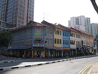
River Valley is a planning area located within the Central Area of the Central Region of Singapore. The planning area shares boundaries with Orchard in the north, Museum in the east, Tanglin in the west and Singapore River in the south.
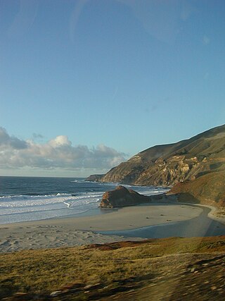
The Little Sur River is a 25.4-mile (40.9 km) long river on the Central Coast of California. The river and its main tributary, the South Fork, drain a watershed of about 40 square miles (100 km2) of the Big Sur area, a thinly settled region of the Central California coast where the Santa Lucia Mountains rise abruptly from the Pacific Ocean. The South Fork and the North Fork both have their headwaters in the Ventana Wilderness, straddling Mount Pico Blanco. Portions west of the national forest and Old Coast Road lie within the El Sur Ranch. Some portions of the North Fork are on land owned by Granite Rock Company of Watsonville, California, which has owned the mineral rights to 2,800 acres (1,100 ha) on Mount Pico Blanco since 1963. The North and South forks converge about 2 miles (3.2 km) from the coast where the river enters the Pacific Ocean.
University Estate is a mainly residential suburb of Cape Town located at the foot of Devil's Peak to the east of the city. University Estate has the postcode 7925.
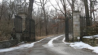
Lincliff is a Georgian Revival house in Glenview near Louisville, Kentucky, United States, built in the early 1910s by William Richardson Belknap.
Southwest Bakersfield is the southwest region of Bakersfield, California. It is roughly bounded by the Kern River to the north and Oak Street/Wible Road to the east. The other boundaries are the city limits themselves.

The R102 road is a regional road in Dublin, Ireland, which describes a broad arc across the north of the city, connecting the N3 — at its M50 motorway intersection — to the R107 on the other side of the city.

The Klamathon Fire was a wildfire in Siskiyou County south of Hornbrook, California in the United States. The fire was reported on July 5, 2018 and was contained on July 21, after burning 38,008 acres (154 km2). The fire threatened private timber lands along the California-Oregon border; public lands in the Klamath National Forest; Rogue River-Siskiyou National Forest; Jackson County, Oregon; communities of Hornbrook and Hilt, California; and Colestin, Oregon. It destroyed 82 structures, damaged 12 structures, injured three firefighters, and killed one civilian.
Glen Deven Ranch is an 860 acres (350 ha) property in Big Sur that was given to the Big Sur Land Trust in 2001 by Seeley and Virginia Mudd. Composed of coastal woodlands, coastal river lands, grasslands and wildlife, it is used by the Trust each summer as an outdoor summer camp to teach inner-city youth about coastal ecosystems. The ranch is accessible via Highway 1 east on Palo Colorado Road, to Garrapatos Road. The ranch's roads also offer residents of Palo Colorado Canyon an emergency exit during a flood or fire.
The M12 is a long metropolitan route in the City of Cape Town, South Africa. It connects Burgundy Estate with Stellenbosch via Parow, Elsie's River and Kuils River.


