
Madera County, officially the County of Madera, is a county at the geographic center of the U.S. state of California. As of the 2020 census, the population was 156,255. The county seat is Madera.

Oakhurst is a census-designated place (CDP) in Madera County, California, United States, 14 miles (23 km) south of the entrance to Yosemite National Park, in the foothills of the Sierra Nevada. At the 2020 census, the population was 5,945, up from 2,829 at the 2010 census. It is part of the Madera metropolitan statistical area.

The Central Valley Project (CVP) is a federal power and water management project in the U.S. state of California under the supervision of the United States Bureau of Reclamation (USBR). It was devised in 1933 in order to provide irrigation and municipal water to much of California's Central Valley—by regulating and storing water in reservoirs in the northern half of the state, and transporting it to the water-poor San Joaquin Valley and its surroundings by means of a series of canals, aqueducts and pump plants, some shared with the California State Water Project (SWP). Many CVP water users are represented by the Central Valley Project Water Association.
Bass Lake, situated in Madera County, California, within the Sierra National Forest and approximately 14 mi (23 km) south of Yosemite National Park, is a popular recreational area. The lake, formed by the Crane Valley Dam on Willow Creek, a tributary to the San Joaquin River, spans about four miles (6.4 km) in length and one-half mile (0.80 km) in width. Constructed in 1910 by Pacific Gas and Electric, the 145 ft (44 m) concrete gravity dam generates hydro-electric power through controlled releases. The lake supports a diverse ecosystem, including species such as black bears, mule deer, bald eagles, and Great blue herons, along with a variety of fish species.

Central California is generally thought of as the middle third of the U.S. state, of California, north of Southern California, which includes Los Angeles, and south of Northern California, which includes San Francisco. It includes the northern portion of the San Joaquin Valley, part of the Central Coast, the central hills of the California Coast Ranges and the foothills and mountain areas of the central Sierra Nevada.
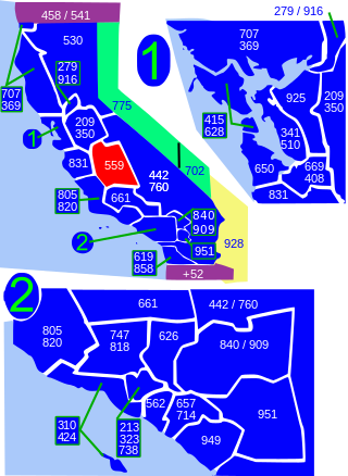
Area code 559 is a telephone area code in the North American Numbering Plan for the central San Joaquin Valley in central California. The numbering plan area includes the counties of Fresno, Madera, Kings, and Tulare, an area largely coextensive with the Fresno and Visalia-Porterville metropolitan areas. The area code was placed in service in 1998, when its services area was split from that of area code 209.

Millerton Lake is an artificial lake near the town of Friant, about 15 mi (24 km) north of downtown Fresno, California, United States. The reservoir was created by the construction of 319 ft high Friant Dam on the San Joaquin River which, with the lake, serves as much of the county line between Fresno County to the south and Madera County to the north.

Mammoth Pool Reservoir is a reservoir on the San Joaquin River in the Sierra Nevada, within the Sierra National Forest in California. It creates the border between Fresno County and Madera County. It is about 45 miles (72 km) north-northeast of Fresno.

The Fresno River is a river in Central California and a major tributary of the San Joaquin River. It runs approximately 83 miles (134 km) from the Sierra Nevada Range to the San Joaquin River if measured from the source of Rainier Creek, near Raymond Mountain in Yosemite National Park. Although called the 'Fresno' River, it is one of the largest and longest river systems in Madera County.
The Chowchilla River is a river in central California, United States and a minor tributary of the San Joaquin River. It flows for 54.2 miles (87.2 km) from the western side of the Sierra Nevada Range to the San Joaquin River system in the San Joaquin Valley.
Minturn is an unincorporated community in Madera County, California. It is located on the Atchison, Topeka and Santa Fe Railroad and California State Route 99 1.5 miles (2 km) north-northwest of Chowchilla, at an elevation of 236 feet. Minturn is near the Geographic Center of California, between Madera and Merced.

Madera station is an unstaffed train station near Madera, California, United States that is served by San Joaquins trains, which run between Oakland or Sacramento and Bakersfield, California.
Fine Gold Creek, in Fine Gold Gulch, is a creek in a gulch in Madera County, California that is a river tributary of the San Joaquin River. It is approximately 18 miles (29 km) from its mouth on the San Joaquin through where it has two forks to its headwaters.
Indian Lakes Estates is an unincorporated community in Madera County, California. It borders the Chukchansi Gold Resort and Casino to the east, and is south of Coarsegold. As of 2000, it was a wooded enclave of 485 homes to working families and retirees, using the two-lane Road 417 as their main residential road. It lies at an elevation of 2247 feet.
Madera Country Club Estates is an unincorporated community in Madera County, California. It lies at an elevation of 295 feet and north of the city of Madera. Development of the area that would be come Madera Country Club Estates began in the 1960's, with construction increasing in the 1970's.
Valley Lake Ranchos is an unincorporated area of Madera County, California. It lies at an elevation of 331 feet, and is located northeast of the city of Madera.
Wishon is a former settlement in Madera County, California. It has been inundated by Bass Lake.

Corte Madera Creek is a short stream which flows southeast for 4.5 miles (7.2 km) in Marin County, California. Corte Madera Creek is formed by the confluence of San Anselmo Creek and Ross Creek in Ross and entering a tidal marsh at Kentfield before connecting to San Francisco Bay near Corte Madera.

The 1934 United Air Lines Boeing 247 crash was an accident involving a Boeing Air Transport-operated United Airlines scheduled flight of a Boeing 247, which crashed in bad weather shortly after departing Salt Lake City, Utah, on February 23, 1934, killing all eight on board. The cause was not immediately determined, but poor weather was considered a factor.

Richardson Island is a former island in San Francisco Bay, in northern California. While it was once surrounded by water and marsh, development of surrounding areas caused it to become completely surrounded by land by the mid-20th century. It is located in Marin County, in the city of Corte Madera. The United States Geological Survey (USGS) gave its elevation as 16 ft (4.9 m) in 1981. It is near the end of Corte Madera Creek, where it flows into San Francisco Bay.


