
The striped bass, also called the Atlantic striped bass, striper, linesider, rock, or rockfish, is an anadromous perciform fish of the family Moronidae found primarily along the Atlantic coast of North America. It has also been widely introduced into inland recreational fisheries across the United States. Striped bass found in the Gulf of Mexico are a separate strain referred to as Gulf Coast striped bass.

The largemouth bass is a carnivorous freshwater ray-finned fish in the Centrarchidae (sunfish) family, native to the eastern and central United States, southeastern Canada and northern Mexico. It is known by a variety of regional names, such as the widemouth bass, bigmouth bass, black bass, bucketmouth, largie, Potter's fish, Florida bass, Florida largemouth, green bass, bucketmouth bass, green trout, Gilsdorf bass, Oswego bass, LMB, and southern largemouth and northern largemouth.
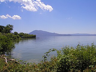
Clear Lake is a natural freshwater lake in Lake County in the U.S. state of California, north of Napa County and San Francisco. It is the largest natural freshwater lake wholly within the state, with 68 square miles (180 km2) of surface area. At an age of 0.5 million years, it is the oldest lake in North America. It is the latest lake to occupy a site with a history of lakes stretching back at least 2,500,000 years.
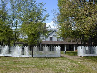
Anderson Marsh State Historic Park is a California State Historic Park and nature reserve preserving a tule marsh, archaeological sites of the Pomo people, and historic ranch structures. It is located in Lake County, California, United States. Anderson Marsh is located at the head of Cache Creek on the southeast corner of Clear Lake, the largest natural lake completely within the borders of California. The park is between the cities of Lower Lake and Clearlake on State Route 53, north of Calistoga in the wine country. The park is open year-round.

Pyramid Lake is a reservoir formed by Pyramid Dam on Piru Creek in the eastern San Emigdio Mountains, near Castaic, Southern California. It is a part of the West Branch California Aqueduct, which is a part of the California State Water Project. Its water is fed by the system after being pumped up from the San Joaquin Valley and through the Tehachapi Mountains.

Lake Havasu is a large reservoir formed by Parker Dam on the Colorado River, on the border between San Bernardino County, California and Mohave County, Arizona. Lake Havasu City sits on the Arizonan side of the lake with its Californian counterpart of Havasu Lake directly across the lake. The reservoir has an available capacity of 619,400 acre-feet (0.7640 km3). The concrete arch dam was built by the United States Bureau of Reclamation between 1934 and 1938. The lake's primary purpose is to store water for pumping into two aqueducts. Prior to the dam construction, the area was home to the Mojave people. The lake was named after the Mojave word for blue. In the early 19th century, it was frequented by beaver trappers. Spaniards also began to mine the areas along the river.
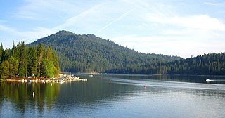
Bass Lake, situated in Madera County, California, within the Sierra National Forest and approximately 14 mi (23 km) south of Yosemite National Park, is a popular recreational area. The lake, formed by the Crane Valley Dam on Willow Creek, a tributary to the San Joaquin River, spans about four miles (6.4 km) in length and one-half mile (0.80 km) in width. Constructed in 1910 by Pacific Gas and Electric, the 145 ft (44 m) concrete gravity dam generates hydro-electric power through controlled releases. The lake supports a diverse ecosystem, including species such as black bears, mule deer, bald eagles, and Great blue herons, along with a variety of fish species.

Lake Berryessa is the largest lake in Napa County, California. This reservoir in the Vaca Mountains was formed following the construction of the Monticello Dam on Putah Creek in the 1950s. Since the early 1960s, this reservoir has provided water and hydroelectricity to the North Bay region of the San Francisco Bay Area.

Trinity Lake, previously called Clair Engle Lake, is an reservoir on the Trinity River formed by the Trinity Dam and located in Trinity County, California, United States. The dam was built by the U.S. Bureau of Reclamation. The lake's capacity is 2,447,650 acre⋅ft (3,019.13 GL), making it one of the largest reservoirs in California. The lake's surface is at 2,370 ft (720 m) above MSL. Trinity Lake captures and stores water for the Central Valley Project, which provides the Central Valley with water for irrigation and produces hydroelectric power. This lake is known for its many small arms, glassy inlets, and good water-skiing conditions.
Oro Grande is an unincorporated community in the Mojave Desert of San Bernardino County, California, United States. It lies on the city boundary of Victorville and Adelanto. It is at 3,000 feet (910 m) elevation in Victor Valley north of the San Bernardino mountain range. It is located on old Route 66 near Interstate 15 between Victorville and Barstow. The ZIP code is 92368 and the community is inside area codes 442 and 760. Less than 1,000 residents live in the unincorporated area.

George Gill Green was a patent medicine entrepreneur, and Union surgeon in the American Civil War.

Castaic Lake is a reservoir formed by Castaic Dam on Castaic Creek, in the Sierra Pelona Mountains of northwestern Los Angeles County, California, United States, near the town of Castaic.
Lake Perris is an artificial lake completed in 1973. It is the southern terminus of the California State Water Project, situated in a mountain-rimmed valley between Moreno Valley and Perris, in what is now the Lake Perris State Recreation Area. The park offers a variety of recreational activities. Because of this and the lake's proximity to major population centers, it is very crowded during the summer months.
Bass Lake is a census-designated place in Madera County, California, United States. It is located 4.5 miles (7.2 km) southeast of Yosemite Forks, at an elevation of 3,415 feet (1,041 m). The population was 575 at the 2020 census.

Silverwood Lake is a large reservoir in San Bernardino County, California, United States, located on the West Fork Mojave River, a tributary of the Mojave River in the San Bernardino Mountains. It was created in 1971 as part of the State Water Project by the construction of the Cedar Springs Dam as a forebay on the 444 mi (715 km) long California Aqueduct, and has a capacity of 73,000 acre⋅ft (90,000,000 m3).
Soldiers Annex Lake is located 75 miles (121 km) southeast of Flagstaff in the state of Arizona. Long Lake is the main lake of the area. The facilities are maintained by Coconino National Forest division of the USDA Forest Service.
Wishon is a former settlement in Madera County, California. It has been inundated by Bass Lake.

The Superior Court of California, County of Mono, also known as the Mono County Superior Court or Mono Superior Court, is the branch of the California superior court with jurisdiction over Mono County.


