
The coyote is a species of canine native to North America. It is smaller than its close relative, the wolf, and slightly smaller than the closely related eastern wolf and red wolf. It fills much of the same ecological niche as the golden jackal does in Eurasia. The coyote is larger and more predatory and was once referred to as the American jackal by a behavioral ecologist. Other historical names for the species include the prairie wolf and the brush wolf.

Morgan Hill is a city in Santa Clara County, California, at the southern tip of Silicon Valley, in the San Francisco Bay Area. Morgan Hill is an affluent residential community, the seat of several high-tech companies, and a dining, entertainment, and recreational destination, owing to its luxury hospitality, wineries, and nature parks.

Anthony Lewis Amonte is an American former professional ice hockey player. He played right wing over 17 seasons in the National Hockey League (NHL) for the New York Rangers, Chicago Blackhawks, Phoenix Coyotes, Philadelphia Flyers and the Calgary Flames. He previously served as the head coach of the Thayer Academy men's varsity hockey team. He is currently a scout with the Florida Panthers.

Desert Diamond Arena is an indoor multi-purpose entertainment arena located in Glendale, Arizona. The venue anchors the 223-acre, $1 billion Westgate Entertainment District.

Coyote Valley is an area located in a narrowing of the southern Santa Clara Valley, in Northern California. Coyote Valley is approximately 7,400 acres (2,995 ha) in size and largely composed of farmland, orchards, open space preserves, and homes. Coyote Valley is generally divided into three sections: North Coyote Valley, the unincorporated village of Coyote, California, and South Coyote Valley.

Don Edwards San Francisco Bay National Wildlife Refuge (DESFBNWR) is a United States National Wildlife Refuge located in the southern part of San Francisco Bay, California. Its headquarters and visitor center are in the Baylands district of Fremont, next to Coyote Hills Regional Park, in Alameda County. The visitor center is on Marshlands Rd, off Thornton Ave.

Coyote is an unincorporated community in a narrowing of Santa Clara Valley astride Coyote Creek, between San Jose and Morgan Hill's Madrone district, in Santa Clara County, California. Part of Coyote is inside the city limits of San Jose. Its ZIP Code is 95013; there is a small U.S. Post Office. It is inside telephone area codes 408 and 669.

Coyote Lake is an artificial lake in Santa Clara County, California, United States, between Morgan Hill and Gilroy.

Bernal Heights Summit or Bernal Heights Hill is a hill in the San Francisco, California neighborhood of Bernal Heights. Upper elevations are part of Bernal Heights Park, which the San Francisco Recreation & Parks Department manages. At its highest elevation (466 ft.) is a privately owned equipment building and 50-foot tall telecommunications tower. The tower does not have an official name, but some residents call it "Sutrito", as it resembles a shorter version of Sutro Tower. The park and summit are largely surrounded by Bernal Heights Boulevard.

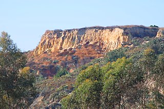
The Coyote Hills are a low mountain range in Alameda County, California.

The Coyote Mountains are a small mountain range in San Diego and Imperial Counties in southern California. The Coyotes form a narrow ESE trending 2 mi (3.2 km) wide range with a length of about 12 mi (19 km). The southeast end turns and forms a 2 mi (3.2 km) north trending "hook". The highest point is Carrizo Mountain on the northeast end with an elevation of 2,408 feet (734 m). Mine Peak at the northwest end of the range has an elevation of 1,850 ft (560 m). Coyote Wash along I-8 along the southeast margin of the range is 100 to 300 feet in elevation. Plaster City lies in the Yuha Desert about 5.5 mi (8.9 km) east of the east end of the range.
The East Coyote Hills are a low mountain range in northern Orange County, California, mostly in the cities of Fullerton and Placentia.
The West Coyote Hills is the area surrounding a ridge in northern Orange County, California. It contains one of the last large open-space area in north Orange County. Parts of it lie within the city limits of La Habra, Buena Park, and La Mirada, with most of it sprawling across western Fullerton between Ralph B. Clark Regional Park and Euclid Street north of Rosecrans Avenue. The foothill region to the east and south is known as Sunny Hills. There is also an East Coyote Hills area, on the east side of Fullerton, that has been almost completely developed for residential real estate.

Anderson Lake, also known as Anderson Reservoir, is an artificial lake in Morgan Hill, located in southern Santa Clara County, California. The reservoir is formed by the damming of Coyote Creek just below its confluence with Las Animas Creek. A 4,275-acre (1,730 ha) county park surrounds the reservoir and provides limited fishing, picnicking, and hiking activities. Although swimming is prohibited, boating, water-skiing, and jet-skiing are permitted in the reservoir.

Coyote Creek is a principal tributary of the San Gabriel River in northwest Orange County, southeast Los Angeles County, and southwest Riverside County, California. It drains a land area of roughly 41.3 square miles (107 km2) covering eight major cities, including Brea, Buena Park, Fullerton, Hawaiian Gardens, La Habra, Lakewood, La Palma, and Long Beach. Some major tributaries of the creek in the highly urbanized watershed include Brea Creek, Fullerton Creek, and Carbon Creek. The mostly flat creek basin is separated by a series of low mountains, and is bounded by several small mountain ranges, including the Chino Hills, Puente Hills, and West Coyote Hills.
The 1984 Morgan Hill earthquake occurred on April 24 at in the Santa Clara Valley of Northern California. The shock had a moment magnitude of 6.2 and a maximum Mercalli intensity of VIII (Severe). The epicenter was located near Mount Hamilton in the Diablo Range of the California Coast Ranges. Nearby communities sustained serious damage with financial losses of at least US$7.5 million.

Colloquially, a coyote is a person who smuggles immigrants across the Mexico–United States border. The word "coyote" is a loanword from Mexican Spanish that usually refers to a species of North American wild dog (Canis latrans).

The Doty Hills are hills in Lewis County and Grays Harbor County in southwest Washington. The hills lie north of Doty, Washington and west of Chehalis, between the Black Hills to their north and the Willapa Hills to their south. They are considered part of the Willapa Hills physiographic province.
Pan Tak is a populated place situated in Pima County, Arizona, United States. Throughout its existence, it has been known by a number of names, including Cajote Spring, Coyote, Coyote Indian Village, Coyote Spring, Coyote Village, Coyotes Spring, Ojo de los Coyotes, and Pantak. Pan Tak become the official name as a result of a Board on Geographic Names decision in 1941. The name comes from the O'odham, meaning "coyote sits". It has an estimated elevation of 3,412 feet (1,040 m) above sea level.
