Orange County is a county in the Los Angeles metropolitan area in the U.S. state of California. As of the 2010 census, the population was 3,010,232, making it the third-most populous county in California, the sixth-most populous in the United States, and more populous than 21 U.S. states. Its county seat is Santa Ana. It is the second most densely populated county in the state, behind San Francisco County. The county's four largest cities by population, Anaheim, Santa Ana, Irvine, and Huntington Beach, each have a population exceeding 200,000. Several of Orange County's cities are on the Pacific Ocean western coast, including Huntington Beach, Newport Beach, Laguna Beach, Dana Point, and San Clemente.

Southern California is a geographic and cultural region that generally comprises California's southernmost counties, and is the second most populous urban agglomeration in the United States. The region is traditionally described as eight counties, based on demographics and economic ties: Imperial, Los Angeles, Orange, Riverside, San Bernardino, San Diego, Santa Barbara, and Ventura. The more extensive 10-county definition, which includes Kern and San Luis Obispo counties, is also used and is based on historical political divisions.

Fullerton is a city located in northern Orange County, California, United States. As of the 2010 census, the city had a total population of 135,161.

Chino Hills State Park is a state park of California, in the United States. It is located in the Chino Hills, foothills of the Santa Ana Mountains. It is a critical link in the Chino–Puente Hills wildlife corridor, and a major botanical habitat reserve for resident and migrating wildlife.

The Santa Ana Mountains are a short peninsular mountain range along the coast of Southern California in the United States. They extend for approximately 61 miles (98 km) southeast of the Los Angeles Basin largely along the border between Orange and Riverside counties.
The Chino Hills are a mountain range on the border of Orange, Los Angeles, and San Bernardino counties, California, with a small portion in Riverside County. The Chino Hills State Park preserves open space and habitat in them.

Henry W. Coe State Park is a state park of California, USA, preserving a vast tract of the Diablo Range. The park is located closest to the city of Morgan Hill, and is located in both Santa Clara and Stanislaus counties. The park contains over 87,000 acres (35,000 ha), making it the largest state park in northern California, and the second-largest in the state. Managed within its boundaries is a designated wilderness area of about 22,000 acres (8,900 ha). This is officially known as the Henry W. Coe State Wilderness, but locally as the Orestimba Wilderness. The 89,164-acre (36,083 ha) park was established in 1959.
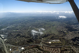
Ralph B. Clark Regional Park is an urban park located in the cities of Fullerton and Buena Park, California. The park is maintained by Orange County Regional Parks, the government division that controls the regional parks in Orange County. The park is south of Rosecrans Avenue at the southern edge of the West Coyote Hills in Buena Park, but both a small section named Camel Hill next to the main park area south of Rosecrans and another small section of the park with six softball fields and a trail located north of Rosecrans Avenue are within Fullerton city limits. The park was originally opened as Los Coyotes Regional Park in 1981, and was renamed in 1987 after then-retiring Orange County Supervisor Ralph B. Clark
(1917–2009).

.
The Coyote Hills are a low mountain-hills range in Plumas County, California.

Anderson Lake, informally called Anderson Reservoir, is an artificial lake in Santa Clara County, California, United States, near Morgan Hill. A 4,275-acre (1,730 ha) county park surrounds the reservoir and provides limited fishing, picnicking, and hiking activities. Although swimming is prohibited, boating, water-skiing and jet-skiing are permitted in the reservoir.

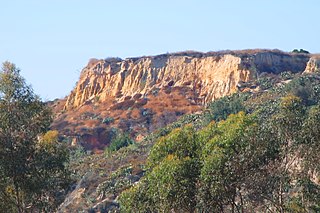
Coyote Creek is a principal tributary of the San Gabriel River in northwest Orange County, southeast Los Angeles County, and southwest Riverside County, California. It drains a land area of roughly 41.3 square miles (107 km2) covering five major cities, including Brea, Buena Park, Fullerton, La Habra, and La Palma. Some major tributaries of the creek in the highly urbanized watershed include Brea Creek, Fullerton Creek, and Carbon Creek. The mostly flat creek basin is separated by a series of low mountains, and is bounded by several small mountain ranges, including the Chino Hills, Puente Hills and West Coyote Hills.
Brea Creek is one of four principal tributaries of Coyote Creek, which is a lower tributary of the San Gabriel River. It drains parts of Orange, Riverside and San Bernardino counties in the southern part of the U.S. state of California. The creek flows 11.7 miles (18.8 km) from the cities of Brea and Anaheim to Whittier, where its mouth is on the left bank of Coyote Creek, at a point 481 feet (147 m) lower in elevation.

The 5,080-acre (20.6 km2) Coyote Mountains Wilderness of Arizona is part of the Coyote Mountains of southern Arizona in the center of Pima County. The wilderness lies about 40 mi southwest of Tucson, in the northwest of the Altar Valley. Kitt Peak is 4 mi WSW.

Fullerton Creek is a tributary of Coyote Creek, which is a lower tributary of the San Gabriel River. The San Gabriel River is found in northwest Orange County, southeast Los Angeles County, and southwest Riverside County in the U.S. state of California.