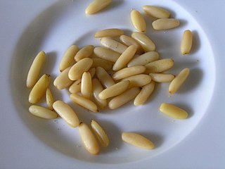
Pine nuts, also called piñón, pinoli, or pignoli, are the edible seeds of pines. According to the Food and Agriculture Organization, only 29 species provide edible nuts, while 20 are traded locally or internationally owing to their seed size being large enough to be worth harvesting; in other pines, the seeds are also edible but are too small to be of notable value as human food. The biggest producers of pine nuts are China, Russia, North Korea, Pakistan and Afghanistan.

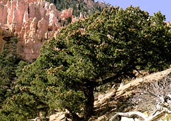
The pinyon or piñon pine group grows in southwestern North America, especially in New Mexico, Colorado, Arizona, and Utah. The trees yield edible nuts, which are a staple food of Native Americans, and widely eaten as a snack and as an ingredient in New Mexican cuisine. The name comes from the Spanish pino piñonero, a name used for both the American varieties and the stone pine common in Spain, which also produces edible nuts typical of Mediterranean cuisine. Harvesting techniques of the prehistoric American Indians are still used today to collect the pinyon seeds for personal use or for commercialization. The pinyon nut or seed is high in fats and calories. In the western United States, pinyon pines are often found in pinyon–juniper woodlands.

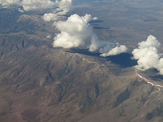
The Great Basin Desert is part of the Great Basin between the Sierra Nevada and the Wasatch Range. The desert is a geographical region that largely overlaps the Great Basin shrub steppe defined by the World Wildlife Fund, and the Central Basin and Range ecoregion defined by the U.S. Environmental Protection Agency and United States Geological Survey. It is a temperate desert with hot, dry summers and snowy winters. The desert spans large portions of Nevada and Utah, and extends into eastern California. The desert is one of the four biologically defined deserts in North America, in addition to the Mojave, Sonoran, and Chihuahuan Deserts.

Pinus cembroides, also known as pinyon pine, Mexican pinyon, Mexican nut pine, and Mexican stone pine, is a pine in the pinyon pine group, native to western North America. It grows in areas with low levels of rainfall and its range extends southwards from Arizona, Texas and New Mexico in the United States into Mexico. It typically grows at altitudes between 1,600 and 2,400 metres. It is a small pine growing to about 20 m (66 ft) with a trunk diameter of up to 50 cm (20 in). The seeds are large and form part of the diet of the Mexican jay and Abert's squirrel. They are also collected for human consumption, being the most widely used pine nut in Mexico. This is a common pine with a wide range and the International Union for Conservation of Nature has rated its conservation status as being of "least concern".
Pinus edulis, the Colorado pinyon, two-needle piñon, pinyon pine, or simply piñon, is a pine in the pinyon pine group native to the Southwestern United States, used for its edible pine nuts.
Pinus monophylla, the single-leaf pinyon, is a pine in the pinyon pine group, native to North America. The range is in southernmost Idaho, western Utah, Arizona, southwest New Mexico, Nevada, eastern and southern California and northern Baja California.

The Vallecito Mountains are located in the Colorado Desert, in eastern San Diego County, Southern California. They are about 28 miles (45 km) north of the U.S. border with Mexico.
The Pine Nut Mountains are a north–south mountain range in the Great Basin, in Douglas and Lyon counties of northwestern Nevada, United States. The highest mountain in the range is Mount Siegel at 9,456 ft.

The mountains in the McCullough Range lie mostly above the city of Henderson in the U.S. state of Nevada. The range has two distinct areas with the northern portion being primarily volcanic in origin, while the southern part of the range is primarily composed of metamorphic rock.

The Sierra Madre Oriental pine–oak forests are a temperate broadleaf and mixed forest ecoregion of northeastern and Central Mexico, extending into the state of Texas in the United States.

The Kiavah Wilderness is a federally designated wilderness area located in the Mojave Desert, Scodie Mountains, and southern Sierra Nevada in Kern County, California, United States. California State Route 178 connects the town of Lake Isabella to State Highway 14 in the east, crossing Walker Pass at the north boundary of the wilderness.
Pinyon Pines is an unincorporated community in Riverside County, California.
The Sylvania Mountains Wilderness is a federally designated wilderness area located 30 miles (48 km) east of Bishop in the state of California. The wilderness is 18,677acres in size and is managed by the Bureau of Land Management (BLM). The California Desert Protection Act of 1994 created the Sylvania Mountains Wilderness and was added to the National Wilderness Preservation System. The wilderness is bordered by Nevada stateline on the east, Piper Mountain Wilderness on the west and Death Valley National Park to the south.
The Pinyon Mountains are a mountain range in eastern San Diego County, Southern California. The range is protected within Anza Borrego Desert State Park.

Sacajawea Peak is a peak in the Wallowa Mountains, in the U.S. state of Oregon. It is in the Eagle Cap Wilderness and the Wallowa–Whitman National Forest.
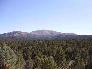
Pinyon–juniper woodland, also spelled piñon–juniper woodland, is a biome found mid-elevations in arid regions of the Western United States, characterized by being an open forest dominated by low, bushy, evergreen junipers, pinyon pines, and their associates. At lower elevations, junipers often predominate and trees are spaced widely, bordering on and mingling with grassland or shrubland, but as elevation increases, pinyon pines become common and trees grow closer, forming denser canopies. Historically, pinyon-juniper woodland has provided a vital source of fuel and food for peoples of the American Southwest.

The Great Basin montane forests is an ecoregion of the Temperate coniferous forests biome, as designated by the World Wildlife Fund (WWF).

The pinyon jay is a species of jay, and is the only member of the genus Gymnorhinus. Native to Western North America, the species ranges from central Oregon to northern Baja California, and eastward as far as western Oklahoma, though wanderers are often sighted beyond this range. It is typically found within foothills, especially where pinyon pines occur.
The Colorado Plateau shrublands is an ecoregion of deserts and xeric shrublands in the Western United States.
