
The Mojave Desert is an arid rain-shadow desert and the driest desert in North America. It is in the North American Southwest, primarily within southeastern California and southern Nevada, and it occupies 47,877 sq mi. Small areas also extend into Utah and Arizona. Its boundaries are generally noted by the presence of Joshua trees, which are native only to the Mojave Desert and are considered an indicator species, and it is believed to support an additional 1,750 to 2,000 species of plants. The central part of the desert is sparsely populated, while its peripheries support large communities such as Las Vegas, Barstow, Lancaster, Palmdale, Victorville, and St. George.

Mojave National Preserve is a United States National Preserve located in the Mojave Desert of San Bernardino County, California, USA, between Interstate 15 and Interstate 40. The preserve was established October 31, 1994, with the passage of the California Desert Protection Act by the US Congress. Previously, it was the East Mojave National Scenic Area, under the jurisdiction of the Bureau of Land Management. At 1,542,776 acres (6,243 km2), it is the third largest unit of the National Park System in the contiguous United States.

The Mojave River is an intermittent river in the eastern San Bernardino Mountains and the Mojave Desert in San Bernardino County, California, United States. Most of its flow is underground, while its surface channels remain dry most of the time, with the exception of the headwaters and several bedrock gorges in the lower reaches.

The Tehachapi Mountains are a mountain range in the Transverse Ranges system of California in the Western United States. The range extends for approximately 40 miles (64 km) in southern Kern County and northwestern Los Angeles County.

Pisgah Crater, or Pisgah Volcano, is a young volcanic cinder cone rising above a lava plain in the Mojave Desert, between Barstow and Needles, California in San Bernardino County, California. The volcanic peak is around 2.5 miles (4.0 km) south of historic U.S. Route 66-National Old Trails Highway and of Interstate 40, and west of the town of Ludlow. The volcano had a historic elevation of 2,638 feet (804 m), but has been reduced to 2,545 feet (776 m) due to mining.

The Mohave Valley is a valley located mostly on the east shore of the south-flowing Colorado River in northwest Arizona. The valley extends into California's San Bernardino County; the northern side of the valley extends into extreme southeast Clark County, Nevada. The main part of the valley lies in southwest Mohave County, Arizona and is at the intersection of the southeast Mojave and northwest Sonoran deserts.

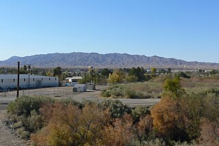
Newberry Springs is an unincorporated community in the western Mojave Desert of Southern California, located at the foot of the Newberry Mountains in San Bernardino County, California, United States. The population at the 2000 census was 2,895.

The Bristol Mountains are found in the Mojave Desert of California, USA, just west of Mojave National Preserve. The range, which reaches an elevation of 3,874 feet, is located in San Bernardino County, and crosses Interstate 40 between Ludlow and the Granite Mountains. At the southern end of the range lies the town of Amboy, the Amboy Crater, and Bristol Dry Lake.

The Chemehuevi Mountains are found at the southeast border of San Bernardino County in southeastern California adjacent the Colorado River. Located south of Needles, California and northwest of the Whipple Mountains, the mountains lie in a north-south direction in general, and are approximately 15 miles in length.

The Clipper Mountains are located in the Eastern Mojave Desert and protected within Mojave Trails National Monument, in San Bernardino County, California.
The Sacramento Mountains are a mountain range in the Eastern Mojave Desert and within Mojave Trails National Monument, in San Bernardino County, California.

The Bigelow Cholla Garden Wilderness is in the eastern Mojave Desert and within Mojave Trails National Monument, located in San Bernardino County, California.
The Castle Mountains are located in the Eastern Mojave Desert, in northeastern San Bernardino County, California and Clark County, Nevada. The range lies south and east of the New York Mountains, southwest of Searchlight and west of Cal-Nev-Ari, Nevada.

The Morongo Basin is an endorheic basin and valley region located in eastern San Bernardino County, in Southern California.
Ludlow is an unincorporated community in the Mojave Desert on Interstate 40, located in San Bernardino County, California, United States. The older remains of the ghost town are along historic Route 66.

The Mojave Road, also known as Old Government Road, is a historic route and present day dirt road across what is now the Mojave National Preserve in the Mojave Desert in the United States. This rough road stretched 147 miles (237 km) from Beale's Crossing, to Fork of the Road location along the north bank of the Mojave River where the old Mojave Road split off from the route of the Old Spanish Trail/Mormon Road.
Interstate 40 (I-40) is a major east–west Interstate Highway in the United States, stretching from Barstow, California, to Wilmington, North Carolina. The segment of I-40 in California is sometimes called the Needles Freeway. It goes east from its western terminus at Interstate 15 in Barstow across the Mojave Desert in San Bernardino County past the Clipper Mountains to Needles, before it crosses over the Colorado River into Arizona east of Needles. All 155 miles (249 km) of I-40 in California are in San Bernardino County.

The Providence Mountains State Recreation Area is located in the Providence Mountains, within the Mojave National Preserve in San Bernardino County, California. It is also home to the Mitchell Caverns Natural Preserve.

Castle Mountains National Monument is a U.S. National Monument located in the eastern Mojave Desert and northeastern San Bernardino County, in the state of California.

Mojave Trails National Monument is a large U.S. National Monument located in the state of California between Interstates 15 and 40. It partially surrounds the Mojave National Preserve. It was designated by President Obama on February 12, 2016 along with Castle Mountains National Monument and Sand to Snow National Monument. It is under the control of the Bureau of Land Management.
