Southern California Bight

Last updated

Southern California Bight
Ensenada del sur de California
ISS061-E-101164 - View of Earth (Cropped).jpg
ISS view of the Southern California Bight, which stretches from Point Conception (top left) to Punta Colonet (bottom left)
Location California, United States
Baja California, Mexico
Coordinates 32°43′N118°21′W / 32.717°N 118.350°W / 32.717; -118.350
Max. length692 km (430 mi)

The Southern California Bight is a 692-kilometer-long (430 mi) stretch of curved coastline that runs along the west coast of the United States and Mexico, from Point Conception in California to Punta Colonet in Baja California, plus the area of the Pacific Ocean defined by that curve. [1] [2] This includes the Channel Islands of California and the Coronado Islands and Islas de Todo Santos of Baja California. [1] [3]

Contents

The region is known for having a climate similar to that of the Mediterranean, consisting of rainy winters and dry summers. The Southern California Bight has a thriving ecosystem that is home to many species of plant life, fish, birds, and mammals.

History

Various Native American peoples occupied the lands in and around the Southern California Bight for tens of thousands of years before the arrival of Europeans. When Spanish explorers arrived in the 16th century the Chumash people occupied the northern coastal region of the bight, as well as the four Northern Channel Islands, [4] and the Tongva (or Gabrieleño) occupied the Los Angeles Basin and Southern Channel Islands. [5] The Payómkawichum and Kumeyaay occupied the southern portion of the bight. [6]

In 1542, at present day San Diego Bay, Juan Rodríguez Cabrillo of Spain, along with his crew, were the first European explorers to land in the region. Cabrillo is said to have been buried on one of the Channel Islands. [5] The first permanent European settlers of the Southern California Bight, led by Juan Pérez, arrived in 1769 on the San Antonio. The Spanish government had planned a three-part occupation plan to check Russian settlement in Alta California. [7] [8]

In 2013-14, scientists witnessed the largest die-off of sea stars ever recorded along the Pacific Coast. The outbreak of sea star wasting disease caused significant changes to the ecosystem as sea stars are a keystone species that plays an important role in controlling the numbers of other creatures. [9]

Geography

Satellite view of the Southern California Bight in California, including the Channel Islands Channelislandsca.jpg
Satellite view of the Southern California Bight in California, including the Channel Islands

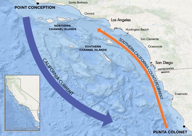
The Southern California Bight stretches for about 692 km (430 mi) along the Pacific coast of North America, of which about 456 km (283 mi) is located within the United States and 236 km (147 mi) is located within Mexico. The rough midpoint of the bight is located about 8 km (5.0 mi) southeast of San Clemente in San Onofre State Beach.

Coastal topology

Mountainous stretch of coastline between Tijuana and Ensenada, Baja California Carretera Escenica Tijuana-Ensenada.jpg
Mountainous stretch of coastline between Tijuana and Ensenada, Baja California

The coastal topology of the Southern California Bight is varied, featuring alluvial plains and marine terraces broken up by mountains of the Transverse and Peninsular Ranges. Numerous islands lie off the coast, the largest of which is Santa Cruz Island of the Channel Islands.

The northern and central portions of the bight are largely urbanized within the Greater Los Angeles and San Diego-Tijuana metropolitan areas, while the rest remains largely rural. Other major cities located along the bight include Santa Barbara, Ventura, Oxnard, Playas de Rosarito, and Ensenada. The Gaviota Coast in Santa Barbara County, California is the last undeveloped stretch of Southern California coastline with dramatic bluffs, isolated beaches and terraced grasslands.

Submarine topology

Notable submarine features include Hueneme Canyon, La Jolla Canyon, Newport Canyon, and Redondo Canyon.

Bodies of water

Major bodies of water that are part of the Southern California Bight include:

Climate

Coastal fog blankets the city of Ensenada on an April evening. The fog typically evaporates by midday. Ensenada Wharf - 8587861111.jpg
Coastal fog blankets the city of Ensenada on an April evening. The fog typically evaporates by midday.

The northern portion of the bight features a predominantly Mediterranean climate (Köppen Csb) with hot, dry summers and mild, wet winters. The central and southern portions of the bight feature a predominantly semi-arid climate (Köppen Bsk) with hot, dry summers and cool, wet winters. A marine layer typically forms just off the coast during late spring and early summer, blanketing coastal communities in cooler air which, if saturated, also contains fog.

There is a difference in monthly mean temperature of 50 °F (10 °C) between the cities of Los Angeles and San Diego. Most precipitation in this coastal area takes place in the months of December, January, and February with a monthly mean rate of 2.0–3.3 inches (51–84 mm) [10]

Biology

The Southern California Bight acts as a transition between many different water masses, including the Pacific subarctic, Pacific equatorial, and the North Pacific central water masses. Due to its central location, the fish fauna includes species native to these other water masses. A total of 481 species of California marine fish, 195 species of birds, and seven species of pinnipeds inhabit the Southern California Bight. [7]

Phytoplankton

Phytoplankton serve an important role in the Southern Californian coastal ecosystem. These single-celled organisms are the main food source for zooplankton and help support the fish population. In doing so, they help establish a stable food chain for all the animals in the coastal region. Since the population of fish is directly related to the production of phytoplankton, the growth in phytoplankton numbers increases the yield of local fisheries. [7]

Fish

A bat ray in a kelp forest located off the coast of San Clemente Island Bat Ray in kelp forest, San Clemente Island, Channel Islands, California.jpg
A bat ray in a kelp forest located off the coast of San Clemente Island

Basking sharks (Cetorhinus maximus) are being studied through a research program begun in 2009 by NOAA. [11]

Common fish found in the epipelagic zone include:

Common fish found in the neritic zone include:

Common fish found in the rocky intertidal zone include:

Many different species of fish rely on the kelp forests as a source of life. Populations of fish are larger in areas with a higher concentration of kelp. Fish that live in and rely on kelp forests include kelp surfperch (Brachyistius frenatus), kelp bass (Paralabrax clathratus), giant kelpfish (Heterostichus rostratus), and kelp rockfish (Sebastes atrovirens). A study conducted near San Luis Obispo, California showed that when kelp was removed from a nearby reef, fish biomass declined by 63%. Juvenile fish rely on kelp beds as nursery grounds. Southern California Edison built a 174-acre kelp reef (70 ha) off San Clemente in 2008. [12]

Birds

Marbled godwit in flight in Bolsa Chica Ecological Reserve Limosa fedoa flight.jpg
Marbled godwit in flight in Bolsa Chica Ecological Reserve

The Southern California Bight is home to 195 species of birds, including endangered species such as the light-footed clapper rail (Rallus longirostris levipes). Some birds nest and hunt near bodies of waters, such as bays, harbors, and oceans, including areas where kelp grows. Some species, such as the brown pelican and some species of cormorants commonly dive head first into the water, attempting to catch fish. Other species of birds, such as grebes and loons migrate from Baja California over the nearshore waters, and will stop to fish and feed. Birds that live in the rocky shore have adapted to finding food, and specialize in prying grabbing prey that clings to the rocky shore. Common birds of the rocky seashore include black oystercatchers (Haemotopus bachmani), wandering tattlers (Heteroscelus incanus), and Surfbirds (Aphorize virgata). Other birds, such as sandpipers, egrets, and herons utilize tidal patterns, venturing out to rocks during low tide in hopes of catching prey. Non-seabirds also nest on rocky seashore surfaces. Peregrine falcons and ravens are known to nest on remote sea cliffs. Sandy beaches are inhabited by plovers, terns, marbled godwits (Limosa fedoa), and several species of gulls. [7] [8]

Marine mammals

Orcas off Santa Rosa Island Orcas off Santa Rosa island.jpg
Orcas off Santa Rosa Island

Due to its central location of warm and cool ocean currents, the Southern California Bight sees a wide variety of marine mammals. Some reside here regularly, some pass through on migratory routes, and others only show up to utilize a certain food source. The Marine Mammal Protection Act and Endangered Species Act helped to prevent any marine mammal "take", which entails hunting, harassing, exploiting marine mammals for their pelt, meat, oil, etc. [7]

Pinnipeds

The most abundant pinnipeds in the Southern California Bight are the California sea lions. Northern elephant seals are known to have breeding grounds in the Southern California Bight, mostly on San Miguel and San Nicolas islands. Sea otters were once common in the Southern California Bight, but due to hunting, they have since mostly retreated to northern waters. Otter sightings in the Southern California Bight happen rarely.

Cetaceans

Gray whales pass through the Southern California Bight on their migration routes, typically migrating very close to land. They pass through the Southern California Bight on their southbound route from December through February towards Baja California, and return northbound towards southern Alaska, passing the Southern California Bight from February to May. Their migration patterns are among the longest of any mammal, spanning over 10,000 miles (16,100 km). Blue whales also use the Southern California Bight as a part of their migratory routes. They leave Baja California by early summer, and are usually present in the Southern California Bight in June. The common dolphin is the most abundant cetacean in the Southern California Bight. Common dolphins typically appear in the Southern California Bight during years with warmer water, and are more abundant in the summer and winter.

Other marine life

A sweet potato sea cucumber found washed up on a beach in Santa Barbara, California Caudina arenicola on a beach.jpg
A sweet potato sea cucumber found washed up on a beach in Santa Barbara, California

The sweet potato sea cucumber (Caudina arenicola) is an endemic species of sea cucumber that digs burrows in loose coastal sediments along the entire length of the bight. The sea cucumbers are often preyed upon by sea birds and larger marine animals. [13]

Natural resources

The Southern California Bight is characterized by coastal and offshore oil reserves. For the past century, the offshore areas of coastal cities such as Goleta, Santa Monica, and Huntington Beach have been home to oil extraction sites. With the presence of these oil reserves comes the construction of relative infrastructure including pipelines.

Other primary resources that come from the Southern California Bight region include anchovies, sardines, mackerel, and bass. The thriving marine life and accessible seafood source has led to the development of harbors and marinas all across the Southern California coast. [14]

Preservation

Marine life off Santa Cruz Island Channel Islands marine life.jpg
Marine life off Santa Cruz Island

The entire coast of California along the bight, including all islands within 12 nautical miles of the mainland, are protected within California Coastal National Monument. The waters around the Channel Islands are protected within both Channel Islands National Park and Channel Islands National Marine Sanctuary.

In Baja California, the ecology of Guadalupe Island, Isla Todos Santos, and the Coronado Islands are protected within the Baja California Pacific Islands Marine Conservation Area. [15]

See also

Related Research Articles

<span class="mw-page-title-main">Gulf of California</span> Gulf of the Pacific Ocean between the Baja California peninsula and the mainland coast of Mexico

The Gulf of California, also known as the Sea of Cortés or Sea of Cortez, or less commonly as the Vermilion Sea, is a marginal sea of the Pacific Ocean that separates the Baja California Peninsula from the Mexican mainland. It is bordered by the states of Baja California, Baja California Sur, Sonora, and Sinaloa with a coastline of approximately 4,000 km (2,500 mi). Rivers that flow into the Gulf of California include the Colorado, Fuerte, Mayo, Sinaloa, Sonora, and the Yaqui. The surface of the gulf is about 160,000 km2 (62,000 sq mi). Maximum depths exceed 3,000 meters (9,800 ft) because of the complex geology, linked to plate tectonics.

<span class="mw-page-title-main">Channel Islands (California)</span> Archipelago off the coast of southern California, US

The Channel Islands are an eight-island archipelago located within the Southern California Bight in the Pacific Ocean, off the coast of California. The four Northern Channel Islands are part of the Transverse Ranges geologic province, and the four Southern Channel Islands are part of the Peninsular Ranges province. Five of the islands are within the Channel Islands National Park, and the waters surrounding these islands make up Channel Islands National Marine Sanctuary. The Nature Conservancy was instrumental in establishing the Channel Islands National Marine Sanctuary.

<i>Haliotis cracherodii</i> Species of gastropod

Haliotis cracherodii, the black abalone, is a species of large edible sea snail, a marine gastropod mollusk in the family Haliotidae, the abalones.

<span class="mw-page-title-main">Coronado Islands</span> Archipelago located within the Southern California Bight off the coast of Baja California, Mexico

The Coronado Islands are a group of islands located 13 km (8 mi) off the northwest coast of the Mexican state of Baja California. Battered by the wind and waves, the rocky islands are mostly uninhabited except for a small military detachment and a lighthouse keeper. Despite their barren appearance, they serve as a refuge for seabirds and support a sizable number of plants, including 6 endemic taxa found only on the islands. The waters around the islands support a considerable amount of diverse marine life.

<span class="mw-page-title-main">Asilomar State Marine Reserve</span> Marine protected area in California

Asilomar State Marine Reserve (SMR) is one of four small marine protected areas (MPAs) located near the cities of Monterey and Pacific Grove, at the southern end of Monterey Bay on California’s central coast. The four MPAs together encompass 2.96 square miles (7.7 km2). The SMR protects all marine life within its boundaries. Fishing and take of all living marine resources is prohibited.

<span class="mw-page-title-main">Año Nuevo State Marine Conservation Area</span> Marine protected area off Californias central coast

Año Nuevo State Marine Conservation Area (SMCA) is one of two adjoining marine protected areas off the coast of San Mateo and Santa Cruz Counties, on California’s central coast. The area is approximately 55 miles south of San Francisco. The SMCA is 11.07 square miles. Except for limited taking of giant kelp, all living marine resources are protected.

<span class="mw-page-title-main">Carmel Pinnacles State Marine Reserve</span> Marine protected area in Carmel Bay

Carmel Pinnacles State Marine Reserve (SMR) is a marine protected area in Carmel Bay including a unique underwater pinnacle formation with adjacent kelp forest, submarine canyon head, and surfgrass. Carmel Bay is adjacent to the city of Carmel-by-the-Sea and is near Monterey, on California's central coast.

<span class="mw-page-title-main">Edward F. Ricketts State Marine Conservation Area</span> Marine protected area in California

Edward F. Ricketts State Marine Conservation Area is one of four small marine protected areas located near the cities of Monterey and Pacific Grove, at the southern end of Monterey Bay on California’s central coast. The four areas together encompass 2.96 square miles (7.7 km2). Within SMCAs fishing and take of all living marine resources is prohibited except the recreational take of finfish by hook-and-line and the commercial take of giant and bull kelp under certain conditions.

<span class="mw-page-title-main">Greyhound Rock State Marine Conservation Area</span> Marine protected area in Californias central coast

Greyhound Rock State Marine Conservation Area (SMCA) is one of two adjoining marine protected areas off the coast of San Mateo County and Santa Cruz County, on California's central coast. The area is approximately 55 miles (89 km) south of San Francisco. The SMCA is 11.81 square miles (30.6 km2). Within the SMCA fishing and take of all living marine resources is prohibited except the recreational take of giant kelp, squid, salmon, and other finfish, subject to various conditions. Also permitted is the commercial take of giant kelp, salmon, and squid, subject to various conditions.

<span class="mw-page-title-main">Lovers Point State Marine Reserve</span> Marine protected area

Lovers Point State Marine Reserve (SMR) is one of four small marine protected areas located near the cities of Monterey and Pacific Grove, at the southern end of Monterey Bay on California’s central coast. The four MPAs together encompass 2.96 square miles (7.7 km2). The SMR protects all marine life within its boundaries. Fishing and take of all living marine resources is prohibited.

<span class="mw-page-title-main">Pacific Grove Marine Gardens State Marine Conservation Area</span> Marine protected area in California

Pacific Grove Marine Gardens State Marine Conservation Area is one of four small marine protected areas located near the cities of Monterey and Pacific Grove, at the southern end of Monterey Bay on California’s central coast. The four MPAs together encompass 2.96 square miles (7.7 km2). Within the SMCA fishing and take of all living marine resources is prohibited except the recreational take of finfish and the commercial take of giant and bull kelp by hand under certain conditions. According to the Frommer's guide, the Marine Gardens area is "renowned for ocean views, flowers, and tide-pool seaweed beds."

<span class="mw-page-title-main">Piedras Blancas State Marine Reserve and Marine Conservation Area</span> Marine protected areas in California

Piedras Blancas State Marine Reserve (SMR) and Piedras Blancas State Marine Conservation Area (SMCA) are two adjoining marine protected areas that lie offshore of San Luis Obispo County on California’s central coast. The combined area of these marine protected areas is 19.68 square miles (51.0 km2). The SMR protects all marine life within its boundaries. Fishing and take of all living marine resources is prohibited. Within the SMCA fishing and take of all living marine resources is prohibited except the commercial and recreational take of salmon and albacore.

Portuguese Ledge State Marine Conservation Area (SMCA) is an offshore marine protected area in Monterey Bay. Monterey Bay is on California’s central coast with the city of Monterey at its south end and the city of Santa Cruz at its north end. The SMCA covers 10.9 square miles (28 km2). Within the SMCA fishing and take of all living marine resources is prohibited except the commercial and recreational take of pelagic finfish.

<span class="mw-page-title-main">Soquel Canyon State Marine Conservation Area</span> Marine protected area in Monterey Bay

Soquel Canyon State Marine Conservation Area (SMCA) is an offshore marine protected area in Monterey Bay. Monterey Bay is on California’s central coast with the city of Monterey at its south end and the city of Santa Cruz at its north end. The SMCA covers 23.41 square miles (60.6 km2). Within the SMCA, fishing and taking of any living marine resources is prohibited except the commercial and recreational take of pelagic finfish.

<span class="mw-page-title-main">White Rock (Cambria) State Marine Conservation Area</span> Marine protected area off the coast of Cambria, California

White Rock (Cambria) State Marine Conservation Area (SMCA) is a marine protected area located off the coast of the city of Cambria, California on California’s central coast. The marine protected area covers 2.32 square miles (6.0 km2). Within the SMCA the take of all living marine resources is prohibited except the commercial take of giant kelp and bull kelp under certain conditions.

<span class="mw-page-title-main">California coastal sage and chaparral</span> Mediterranean forests, woodlands, and scrub ecoregion in Mexico and the United States

The California coastal sage and chaparral is a Mediterranean forests, woodlands, and scrub ecoregion located in southwestern California and northwestern Baja California (Mexico). It is part of the larger California chaparral and woodlands ecoregion.

San Diego-Scripps Coastal Marine Conservation Area (SMCA) and Matlahuayl State Marine Reserve (SMR) are adjoining marine protected areas that extend offshore from La Jolla in San Diego County on California’s south coast. The two marine protected areas cover 2.51 square miles. San Diego-Scripps Coastal SMCA prohibits the take of all living marine resources except that coastal pelagic species, not including market squid, may be taken recreationally by hook and line. Matlahuayl SMR prohibits the take of all living marine resources.

<span class="mw-page-title-main">Fauna of California</span> Flora and fauna of the US state of California

The fauna of the State of California may be the most diverse in the United States of America. Of the Lower 48 conterminous states, California has the greatest diversity in climate, terrain and geology in general. The state's six life zones are the lower Sonoran (desert); upper Sonoran ; transition ; and the Canadian, Hudsonian, and Arctic zones, comprising California's highest elevations. California’s diverse geography gives rise to dozens of different ecosystems, each of which has its own unique native plants and animals. California is a huge state, the 3rd largest in the U.S., and can range broadly in habitat type.

<i>Sebastes atrovirens</i> Species of fish

Sebastes atrovirens, the kelp rockfish, is a species of marine ray-finned fish belonging to the subfamily Sebastinae, the rockfishes, part of the family Scorpaenidae. It is native to the Pacific Ocean along the coast of California in the United States and Baja California in Mexico.

<span class="mw-page-title-main">Anacapa State Marine Reserve</span> Marine reserve in the United States

The Anacapa State Marine Reserve (SMR) is a protected marine reserve located off the coast of Southern California, encompassing the area of water immediately north of Anacapa Island. Established to safeguard the marine ecosystems and biodiversity of the region, the reserve is one of the thirteen Marine Protected Areas (MPAs) of the larger Channel Islands National Park network.

References

  1. 1 2 "Restoration Activities - Montrose/PV Shelf, CA - Southwest Region - DARRP". webarchive.library.unt.edu. Retrieved November 26, 2020.
  2. "Southern California Bight Regional Monitoring Program". Southern California Coastal Water Research Project. Retrieved November 26, 2020.
  3. Dailey, M. D., Reish, D. J., Anderson, J. W. (editors), 1993. Ecology of the Southern California Bight: A Synthesis and Interpretation. University of California Press, Berkeley / Los Angeles / London, 926 pp.
  4. Ward, Michael K. "Timoloqinash: Incorporating Chumash Cultural Self-History into the History of California" (PDF). Wishtoyo. Archived from the original (PDF) on April 4, 2015.
  5. 1 2 Encyclopædia Britannica, Editors of. "Channel Islands (islands, California, United States)". Encyclopædia Britannica. Encyclopædia Britannica, Inc. Archived from the original on June 12, 2020. Retrieved July 24, 2020.{{cite web}}: |first1= has generic name (help)
  6. "KUMEYAAY MAP 1776 Kumeyaay Territory, 2005 California Indian Reservations". www.kumeyaay.info.
  7. 1 2 3 4 5 6 Dailey, Murray. "Ecology of the Southern California Bight".
  8. 1 2 Lentz, Joan (2006). Introduction to Birds of the Southern California Coast. ISBN   9780520243217.
  9. Netburn, Deborah (November 26, 2014) "Scientists find likely culprit behind mysterious sea star deaths" Los Angeles Times
  10. Panel on Southern California Bight of the Committee on a Systems Assessment of Marine Environmental Monitoring (February 1990). Monitoring Southern California's Coastal Waters. ISBN   9780309043274.
  11. Carlson, Cheri (May 3, 2018). "Sharks the length of a small bus are showing up off Ventura and some say that's great news". Ventura County Star. Retrieved May 7, 2019.
  12. Swegles, Fred (April 17, 2015). "Artificial reef: plenty of kelp, not enough fish". The Orange County Register.
  13. "Sweet Potato Sea Cucumber (Caudina arenicola)". iNaturalist. Retrieved June 10, 2021.
  14. Panel on Southern California Bight of the Committee on a Systems Assessment of Marine Environmental Monitoring (February 1990). Monitoring Southern California's Coastal Waters. ISBN   9780309043274.
  15. "Conservación de islas | Prevenir extinciones y proteger a las especies y hábitat insulares". www.islas.org.mx. Retrieved May 1, 2022.