
The Cenozoic is Earth's current geological era, representing the last 66 million years of Earth's history. It is characterised by the dominance of mammals, birds and flowering plants. It is the latest of three geological eras, preceded by the Mesozoic and Paleozoic. The Cenozoic started with the Cretaceous–Paleogene extinction event, when many species, including the non-avian dinosaurs, became extinct in an event attributed by most experts to the impact of a large asteroid or other celestial body, the Chicxulub impactor.
The Mesozoic Era is the second-to-last era of Earth's geological history, lasting from about 252 to 66 million years ago, comprising the Triassic, Jurassic and Cretaceous Periods. It is characterized by the dominance of archosaurian reptiles, such as the dinosaurs; an abundance of gymnosperms, and ferns; a hot greenhouse climate; and the tectonic break-up of Pangaea. The Mesozoic is the middle of the three eras since complex life evolved: the Paleozoic, the Mesozoic, and the Cenozoic.
The PaleozoicEra is the first of three geological eras of the Phanerozoic Eon. Beginning 538.8 million years ago (Ma), it succeeds the Neoproterozoic and ends 251.9 Ma at the start of the Mesozoic Era. The Paleozoic is subdivided into six geologic periods :
The Precambrian is the earliest part of Earth's history, set before the current Phanerozoic Eon. The Precambrian is so named because it preceded the Cambrian, the first period of the Phanerozoic Eon, which is named after Cambria, the Latinised name for Wales, where rocks from this age were first studied. The Precambrian accounts for 88% of the Earth's geologic time.

The Coast Mountains are a major mountain range in the Pacific Coast Ranges of western North America, extending from southwestern Yukon through the Alaska Panhandle and virtually all of the Coast of British Columbia south to the Fraser River. The mountain range's name derives from its proximity to the sea coast, and it is often referred to as the Coast Range. The range includes volcanic and non-volcanic mountains and the extensive ice fields of the Pacific and Boundary Ranges, and the northern end of the volcanic system known as the Cascade Volcanoes. The Coast Mountains are part of a larger mountain system called the Pacific Coast Ranges or the Pacific Mountain System, which includes the Cascade Range, the Insular Mountains, the Olympic Mountains, the Oregon Coast Range, the California Coast Ranges, the Saint Elias Mountains and the Chugach Mountains. The Coast Mountains are also part of the American Cordillera—a Spanish term for an extensive chain of mountain ranges—that consists of an almost continuous sequence of mountain ranges that form the western backbone of North America, Central America, South America and Antarctica.

The geology of the Appalachians dates back more than 1.1 billion years to the Mesoproterozoic era when two continental cratons collided to form the supercontinent Rodinia, 500 million years prior to the later development of the range during the formation of the supercontinent Pangea. The rocks exposed in today's Appalachian Mountains reveal elongate belts of folded and thrust faulted marine sedimentary rocks, volcanic rocks and slivers of ancient ocean floor – strong evidence that these rocks were deformed during plate collision. The birth of the Appalachian ranges marks the first of several mountain building plate collisions that culminated in the construction of the supercontinent Pangea with the Appalachians and neighboring Anti-Atlas mountains near the center. These mountain ranges likely once reached elevations similar to those of the Alps and the Rocky Mountains before they were eroded.

The Laramide orogeny was a time period of mountain building in western North America, which started in the Late Cretaceous, 80 to 70 million years ago, and ended 55 to 35 million years ago. The exact duration and ages of beginning and end of the orogeny are in dispute. The Laramide orogeny occurred in a series of pulses, with quiescent phases intervening. The major feature that was created by this orogeny was deep-seated, thick-skinned deformation, with evidence of this orogeny found from Canada to northern Mexico, with the easternmost extent of the mountain-building represented by the Black Hills of South Dakota. The phenomenon is named for the Laramie Mountains of eastern Wyoming. The Laramide orogeny is sometimes confused with the Sevier orogeny, which partially overlapped in time and space.

The Explorer Plate is an oceanic tectonic plate beneath the Pacific Ocean off the west coast of Vancouver Island, Canada, which is partially subducted under the North American Plate. Along with the Juan de Fuca Plate and Gorda Plate, the Explorer Plate is a remnant of the ancient Farallon Plate, which has been subducted under the North American Plate. The Explorer Plate separated from the Juan de Fuca Plate roughly 4 million years ago. In its smoother, southern half, the average depth of the Explorer plate is roughly 2,400 metres (7,900 ft) and rises up in its northern half to a highly variable basin between 1,400 metres (4,600 ft) and 2,200 metres (7,200 ft) in depth.

The richly textured landscape of the United States is a product of the dueling forces of plate tectonics, weathering and erosion. Over the 4.5 billion-year history of the Earth, tectonic upheavals and colliding plates have raised great mountain ranges while the forces of erosion and weathering worked to tear them down. Even after many millions of years, records of Earth's great upheavals remain imprinted as textural variations and surface patterns that define distinctive landscapes or provinces.

The Australian Plate is a major tectonic plate in the eastern and, largely, southern hemispheres. Originally a part of the ancient continent of Gondwana, Australia remained connected to India and Antarctica until approximately 100 million years ago when India broke away and began moving north. Australia and Antarctica had begun rifting by 96 million years ago and completely separated a while after this, some believing as recently as 45 million years ago ,but most accepting presently that this had occurred by 60 million years ago.

The Caribbean Plate is a mostly oceanic tectonic plate underlying Central America and the Caribbean Sea off the northern coast of South America.

The geology of the Rocky Mountains is that of a discontinuous series of mountain ranges with distinct geological origins. Collectively these make up the Rocky Mountains, a mountain system that stretches from Northern British Columbia through central New Mexico and which is part of the great mountain system known as the North American Cordillera.

Volcanic activity is a major part of the geology of Canada and is characterized by many types of volcanic landform, including lava flows, volcanic plateaus, lava domes, cinder cones, stratovolcanoes, shield volcanoes, submarine volcanoes, calderas, diatremes, and maars, along with less common volcanic forms such as tuyas and subglacial mounds.

The geology of the Pacific Northwest includes the composition, structure, physical properties and the processes that shape the Pacific Northwest region of North America. The region is part of the Ring of Fire: the subduction of the Pacific and Farallon Plates under the North American Plate is responsible for many of the area's scenic features as well as some of its hazards, such as volcanoes, earthquakes, and landslides.
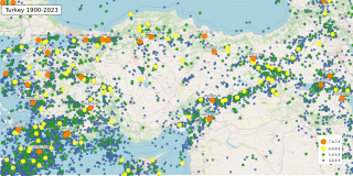
The geology of Turkey is the product of a wide variety of tectonic processes that have shaped Anatolia over millions of years, a process which continues today as evidenced by frequent earthquakes and occasional volcanic eruptions.

The geological history of the Earth follows the major geological events in Earth's past based on the geological time scale, a system of chronological measurement based on the study of the planet's rock layers (stratigraphy). Earth formed about 4.54 billion years ago by accretion from the solar nebula, a disk-shaped mass of dust and gas left over from the formation of the Sun, which also created the rest of the Solar System.

Geology of Colombia refers to the geological composition of the Republic of Colombia that determines its geography. Most of the emerged territory of Colombia covers vast areas within the South American plate, whereas much submerged territory lies within the Caribbean plate and the Nazca plate.

The Coast Range Arc was a large volcanic arc system, extending from northern Washington through British Columbia and the Alaska Panhandle to southwestern Yukon. The Coast Range Arc lies along the western margin of the North American Plate in the Pacific Northwest of western North America. Although taking its name from the Coast Mountains, this term is a geologic grouping rather than a geographic one, and the Coast Range Arc extended south into the High Cascades of the Cascade Range, past the Fraser River which is the northward limit of the Cascade Range proper.
The West African Craton (WAC) is one of the five cratons of the Precambrian basement rock of Africa that make up the African Plate, the others being the Kalahari craton, Congo craton, Saharan Metacraton and Tanzania Craton. Cratons themselves are tectonically inactive, but can occur near active margins, with the WAC extending across 14 countries in Western Africa, coming together in the late Precambrian and early Palaeozoic eras to form the African continent. It consists of two Archean centers juxtaposed against multiple Paleoproterozoic domains made of greenstone belts, sedimentary basins, regional granitoid-tonalite-trondhjemite-granodiorite (TTG) plutons, and large shear zones. The craton is overlain by Neoproterozoic and younger sedimentary basins. The boundaries of the WAC are predominantly defined by a combination of geophysics and surface geology, with additional constraints by the geochemistry of the region. At one time, volcanic action around the rim of the craton may have contributed to a major global warming event.

The geology of North America is a subject of regional geology and covers the North American continent, the third-largest in the world. Geologic units and processes are investigated on a large scale to reach a synthesized picture of the geological development of the continent.