Related Research Articles

The Santa Cruz, Big Trees and Pacific Railway is a freight and heritage railroad in Northern California.
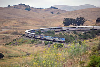
The Coast Line is a railroad line between Burbank, California and the San Francisco Bay Area, roughly along the Pacific Coast. It is the shortest rail route between Los Angeles and the Bay Area.

Bell Station is an unincorporated community located along State Route 152 between Casa de Fruta and Pacheco Pass near the southeast extent of Santa Clara County, California.

Redwood Estates is a rural unincorporated community along State Route 17 in the coastal Santa Cruz Mountains in Los Gatos, California, United States. The Census Bureau includes it in a census-designated place named Lexington Hills. It lies inside the confines of Santa Clara County. The area is about eight miles from downtown Los Gatos and nine miles from the Santa Cruz County community of Scotts Valley.
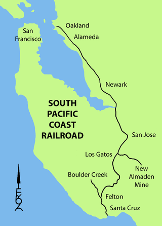
The South Pacific Coast Railroad (SPC) was a 3 ft narrow gauge steam railroad running between Santa Cruz, California and Alameda, with a ferry connection in Alameda to San Francisco. The railroad was created as the Santa Clara Valley Railroad, founded by local strawberry growers as a way to get their crops to market in San Francisco and provide an alternative to the Southern Pacific Railroad. In 1876, James Graham Fair, a Comstock Lode silver baron, bought the line and extended it into the Santa Cruz Mountains to capture the significant lumber traffic coming out of the redwood forests. The narrow-gauge line was originally laid with 52-pound-per-yard (26 kg/m) rail on 8-foot (2.44 m) redwood ties; and was later acquired by the Southern Pacific and converted to 4 ft 8+1⁄2 instandard gauge.
Swanton is a small community in an unincorporated area of Santa Cruz County on the Pacific coast, situated about 5 miles (8.0 km) north of the town of Davenport, to the east of State Route 1 on Swanton Road. The US Geological Survey designates Swanton as a populated place located at latitude and longitude 37.06417°N 122.22639°W with an elevation of 135 ft (41 m). The ZIP Code is 95017 and the community is inside area code 831.
Sargent is a ghost town located in central California on the Santa Clara-San Benito County border. The largest portion of the town was on the Santa Clara County, or north, side of the county line. It is 150 feet above mean sea level. It appeared on 1950s Thomas Brothers maps but has dropped off the company's 21st century maps.

The Ocean Shore Railroad was a railroad built between San Francisco and Tunitas Glen, and Swanton and Santa Cruz that operated along the Pacific coastline from 1905 until 1921. The route was originally conceived to be a continuous line between San Francisco and Santa Cruz, but the 1906 San Francisco Earthquake, financial difficulties, and the advent of the automobile caused the line to never reach its goals, and remain with a Northern and Southern division.
Ogilby is a ghost town in Imperial County, California, United States. Ogilby is located on the Southern Pacific Railroad 42 miles (68 km) east of El Centro, and 3.8 miles (6.1 km) north of Interstate 8 on County Road S34. The name is official for federal use, and a feature ID number of 252950 has been assigned. Ogilby is defined by the US Geological Survey as a populated place at 356 feet (109 m) AMSL elevation. NAD27 latitude and longitude are listed at 32°49′01″N114°50′20″W on the "Ogilby, California" 7.5-minute quadrangle (map). It is included in the Imperial County Air Pollution Control District. It lies at an elevation of 364 feet (111 m).
Summit is a small unincorporated community more frequently referred to by locals as the Loma Prieta Community located partially in Santa Clara County but predominantly in Santa Cruz County, California, in the mountain ranges of the Santa Cruz Mountains. It lies at the summit along Highway 17 from which is gets its name. Home to a series of abandoned railroad towns and tunnels from a Los Gatos to Felton route before the 1940s, Public transportation by bus is also no longer available from the Summit Road area. VTA route 76 has been cancelled since June 2010, and the Highway 17 Express only stops in Scotts Valley. It is one of the few places in the San Francisco Bay Area to receive snowfall and the mountain pass which links the Silicon Valley and Monterey Bay is closed at this spot when snowfall is too heavy. The next town to the south is Scotts Valley and to the north Redwood Estates. The area serves as a rest stop with food for people traveling across the mountains. It straddles the county line with Santa Clara County and is south of the unincorporated area of Lexington Hills with which it shares a zip code. The ZIP Code is 95033 and the community is inside area code 408.

Wrights, California is a ghost town in unincorporated west Santa Clara County, California. It is located near Summit Road in the Santa Cruz Mountains, on the north bank of Los Gatos Creek, east of State Route 17.

Laurel is a ghost town in Santa Cruz County, California, United States, in the Santa Cruz Mountains. It is in a valley at an elevation of 900 feet (270 m) above sea level.
Lexington, California, is a ghost town in Santa Clara County, now submerged by the Lexington Reservoir. Originally located along Los Gatos Creek, the town was 550 feet above sea level.

Alma is a ghost town and drowned town in Santa Clara County in California, United States. It lies beneath the waters of the Lexington Reservoir above Los Gatos. The location is latitude 37.18N and longitude 121.98W. It was 551 feet above sea level.

Patchen is a ghost town nestled in the Santa Cruz Mountains, in Santa Clara County, California. It is located along the old Santa Cruz Highway.

Glenwood, California, is an unincorporated area of Santa Cruz County. It is located at coordinates 37°6′29″N121°59′8″W, and is 891 feet above sea level.
Eccles, California is a ghost town in Santa Cruz County, near Felton, east of Ben Lomond. It was near where Lompico Creek flows into Zayante Creek.
Burrell, California was an early settlement in Santa Cruz County near the summit of the Santa Cruz Mountains, 1.5 miles (2.4 km) south-southeast of Wrights. It was named for Lyman John Burrell, who settled there in the early 1850s. There was a Burrell School, which was later abandoned. A hotel was operated by James Richard Wright, whose son John Vincent Wright was honored by the naming of Wright's Station, which was more commonly known as Wrights.
Ady is an unincorporated historic locale in Klamath County, Oregon, United States.
The Santa Cruz and Monterey Bay Railroad (SCMB), or Santa Cruz Branch Rail Line (SCBRL), is a historic railway running through Santa Cruz County, California. It once ran operationally from Davenport to the Watsonville Junction where it connected to the Union Pacific Coast Line. Over the years it has had many splays and connections to other local railroads over, through, and around the Santa Cruz Mountains. It is still active today, including a connection with the Roaring Camp Railroads line that makes regular trips between Felton and the Santa Cruz Beach Boardwalk.
References
- 1 2 Clems (historical), California: Clems (historical), California Latitude and Longitude
- ↑ Patchen, California - History of this early Santa Cruz Mountain town
- ↑ U.S. Geological Survey historic maps
- ↑ U.S. Geological Survey map, 1940
