Yosemite National Park is a national park in California. It is bordered on the southeast by Sierra National Forest and on the northwest by Stanislaus National Forest. The park is managed by the National Park Service and covers 759,620 acres in four counties – centered in Tuolumne and Mariposa, extending north and east to Mono and south to Madera. Designated a World Heritage Site in 1984, Yosemite is internationally recognized for its cliffs, waterfalls, clear streams, giant sequoia groves, lakes, mountains, meadows, glaciers, and biological diversity. Almost 95 percent of the park is designated wilderness. Yosemite is one of the largest and least fragmented habitat blocks in the Sierra Nevada.

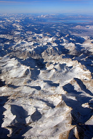
The Sierra Nevada is a mountain range in the Western United States, between the Central Valley of California and the Great Basin. The vast majority of the range lies in the state of California, although the Carson Range spur lies primarily in Nevada. The Sierra Nevada is part of the American Cordillera, an almost continuous chain of mountain ranges that forms the western "backbone" of the Americas.

The Pacific Crest Trail (PCT), officially designated as the Pacific Crest National Scenic Trail, is a long-distance hiking and equestrian trail closely aligned with the highest portion of the Cascade and Sierra Nevada mountain ranges, which lie 100 to 150 miles east of the U.S. Pacific coast. The trail's southern terminus is next to the Mexico–United States border, just south of Campo, California, and its northern terminus is on the Canada–US border, upon which it continues unofficially to the Windy Joe Trail within Manning Park in British Columbia; it passes through the states of California, Oregon, and Washington.

The John Muir Trail (JMT) is a long-distance trail in the Sierra Nevada mountain range of California, passing through Yosemite, Kings Canyon and Sequoia National Parks. It is named after John Muir, a naturalist.

The Humboldt–Toiyabe National Forest (HTNF) is the principal U.S. National Forest in the U.S. state of Nevada, and has a smaller portion in Eastern California. With an area of 6,289,821 acres (25,454.00 km2), it is the largest U.S. National Forest outside of Alaska.

The Sierra Club is an American environmental organization with chapters in all 50 U.S. states, Washington D.C., and Puerto Rico. The club was founded on May 28, 1892, in San Francisco, California, by Scottish-American preservationist John Muir, who became the first president as well as the longest-serving president, at approximately 20 years in this leadership position. The Sierra Club operates only in the United States and holds the legal status of 501(c)(4) nonprofit social welfare organization. Sierra Club Canada is a separate entity.

Sequoia National Park is an American national park in the southern Sierra Nevada east of Visalia, California. The park was established on September 25, 1890, and today protects 404,064 acres of forested mountainous terrain. Encompassing a vertical relief of nearly 13,000 feet (4,000 m), the park contains the highest point in the contiguous United States, Mount Whitney, at 14,505 feet (4,421 m) above sea level. The park is south of, and contiguous with, Kings Canyon National Park; both parks are administered by the National Park Service together as the Sequoia and Kings Canyon National Parks. UNESCO designated the areas as Sequoia-Kings Canyon Biosphere Reserve in 1976.

Mount Ritter is the highest mountain in Madera County, California, in the Western United States, at an elevation of 13,149 feet (4,008 m). It is also the highest and most prominent peak of its namesake, the Ritter Range, a subrange of the Sierra Nevada in the Ansel Adams Wilderness of the Inyo and Sierra National Forests. Mount Ritter is the 15th highest mountain peak in California with at least 500 meters of topographic prominence.

Joseph Nisbet LeConte was an American explorer of the Sierra Nevada. He was also a cartographer, a photographer and a professor of mechanical engineering.

Tahoe National Forest is a United States National Forest located in California, northwest of Lake Tahoe. It includes the 8,587-foot (2,617 m) peak of Sierra Buttes, near Sierra City, which has views of Mount Lassen and Mount Shasta. It is located in parts of six counties: Sierra, Placer, Nevada, Yuba, Plumas and El Dorado. The forest has a total area of 871,495 acres. Its headquarters is in Nevada City, California. There are local ranger district offices in Camptonville, Foresthill, Sierraville and Truckee.
Camp Lake is a small tarn located in the Emigrant Wilderness in Tuolumne County, California, approximately 10 km (6.2 mi) north of Yosemite National Park. It is accessible only to hikers and equestrians via the popular Deer Lake Trail.

Minaret Summit is a mountain pass on Highway 203 in the central Sierra Nevada. The pass, lying on the Madera-Mono County border, is within the Mammoth Ranger District of the Inyo National Forest and located near Devils Postpile National Monument, Mammoth Lakes, and Mammoth Mountain. The elevation of the pass is about 9,265 ft (2,824 m). Highway 203 ends at Minaret Summit. The road continues, now called Reds Meadow Road, until its dead end at the Reds Meadow Pack Station near the Rainbow Falls trailhead.

Leavitt Peak is located in the Emigrant Wilderness near Sonora Pass in the eastern Sierra Nevada range of California. Leavitt Peak is located on the Tuolumne County - Mono County line. The Pacific Crest Trail runs close to the east of Leavitt Peak, at an elevation of about 10,800 feet (3,290 m) elevation. The peak offers views south to Yosemite National Park and north towards South Lake Tahoe.

The Sacatar Trail Wilderness is a federally designated wilderness area located 20 miles (32 km) northwest of Ridgecrest, California USA. It was created in 1994 with the passage of the California Desert Protection Act - Public Law 103-433 - and is managed by the Bureau of Land Management (BLM). The wilderness is 51,900 acres (210 km2) in size and protects portions of the southern Sierra Nevada Mountain Range.

The Golden Trout Wilderness is a federally designated wilderness area in the Sierra Nevada, in Tulare County and Inyo County, California. It is located 40 miles (64 km) east of Porterville within Inyo National Forest and Sequoia National Forest.

Jules Marquard Eichorn was an American mountaineer, environmentalist, and music teacher.
The High Trips were large annual wilderness excursions organized and led by the Sierra Club, beginning in 1901. The High Trips lasted until the early 1970s, and were replaced by a larger number of smaller trips to wilderness areas worldwide.

Mount Mills is a Thirteener and California 4000 meter peak, on the Sierra Crest, north of Mount Abbot and south of Mono Pass in the Sierra Nevada.

Mount McAdie is a summit on the crest of the Sierra Nevada, and is located 2.1 miles (3.4 km) south of Mount Whitney. It has three summits, with the north peak being the highest. The summit ridge marks the boundary between Sequoia National Park and the John Muir Wilderness. It is also on the boundary between Inyo and Tulare counties. Lone Pine, 12.4 miles (20.0 km) to the northeast, is in the Owens Valley on U.S. 395.

Hell for Sure Lake is an Alpine lake located in the John Muir Wilderness, which is part of the Sierra Nevada mountain range. The lake is at an elevation of 10,768 feet (3,282 m), has a few small rocky islands and is between Red Mountain to the north and Mount Hutton to the south. The Hell for Sure trail and Hell for Sure Pass both are named after this lake with the region being known for its rough terrain. The rocks the surround Hell for Sure Lake and its nearby mountains are estimated to be over 100 million years old.


