
Brooklyn is a borough of New York City. Located on the westernmost edge of Long Island, it is coextensive with Kings County in the U.S. state of New York. With 2,736,074 residents as of the 2020 United States census, Kings County is the most populous of the five boroughs of New York City and the most populous county in the State of New York. The population density of Brooklyn was 37,339.9 inhabitants per square mile (14,417.0/km2) in 2022, making it the second-most-densely-populated county in the United States, behind Manhattan, and it had the ninth-highest population of any county nationwide. Were Brooklyn still an independent city, it would be the fourth most populous in the U.S. after the rest of New York City, Los Angeles, and Chicago.

Bay Ridge is a neighborhood in the southwest corner of the New York City borough of Brooklyn. It is bounded by Sunset Park to the north, Dyker Heights to the east, the Narrows and the Belt Parkway to the west, and Fort Hamilton Army Base and the Verrazzano-Narrows Bridge to the south. The section of Bay Ridge south of 86th Street is sometimes considered part of a sub-neighborhood called Fort Hamilton.

Dyker Heights is a predominantly residential neighborhood in the southwest corner of the borough of Brooklyn in New York City. It is on a hill between Bay Ridge, Bensonhurst, Borough Park, and Gravesend Bay. The neighborhood is bounded by 7th and 14th Avenues, 65th Street, and the Belt Parkway on the west, east, north, and south, respectively.

Gravesend is a neighborhood in the south-central section of the New York City borough of Brooklyn, on the southwestern edge of Long Island in the U.S. state of New York. It is bounded by the Belt Parkway to the south, Bay Parkway to the west, Avenue P to the north, and Ocean Parkway to the east.
Red Hook is a neighborhood in western Brooklyn, New York City, New York, within the area once known as South Brooklyn. It is located on a peninsula projecting into the Upper New York Bay and is bounded by the Gowanus Expressway and the Carroll Gardens neighborhood on the northeast, Gowanus Canal on the east, and the Upper New York Bay on the west and south. A prosperous shipping and port area in the early 20th century, the area declined in the latter part of the century. Today it is home to the Red Hook Houses, the largest housing project in Brooklyn.
Sunset Park is a neighborhood in the western part of the New York City borough of Brooklyn, bounded by Park Slope and Green-Wood Cemetery to the north, Borough Park to the east, Bay Ridge to the south, and New York Harbor to the west. The neighborhood is named for a public park of the same name that covers 24.5 acres (9.9 ha) between Fifth and Seventh Avenues from 41st to 44th Street. The area north of 36th Street is alternatively known as Greenwood Heights, while the section north of 24th Street is also called South Slope.

Dumbo is a neighborhood in the New York City borough of Brooklyn. It encompasses two sections: one located between the Manhattan and Brooklyn Bridges, which connect Brooklyn to Manhattan across the East River, and another that continues east from the Manhattan Bridge to the Vinegar Hill area. The neighborhood is bounded by Brooklyn Bridge Park to the north, the Brooklyn Bridge to the west, Brooklyn Heights to the south and Vinegar Hill to the east. Dumbo is part of Brooklyn Community Board 2.

The Bedford Park Boulevard–Lehman College station is a local station on the IRT Jerome Avenue Line of the New York City Subway. Located at the intersection of Bedford Park Boulevard immediately west of Jerome Avenue in the Bronx, it is served by the 4 train at all times. It is also the only station on the Jerome Avenue Line north of 170th Street that is not located above Jerome Avenue. This station was constructed by the Interborough Rapid Transit Company as part of the Dual Contracts and opened in 1918.

Windsor Terrace is a small residential neighborhood in the central part of the New York City borough of Brooklyn. It is bounded by Prospect Park on the east and northeast, Park Slope at Prospect Park West, Green-Wood Cemetery, and Borough Park at McDonald Avenue on the northwest, west, and southwest, and Kensington at Caton Avenue on the south. As of the 2010 United States Census, Windsor Terrace had 20,988 people living within its 0.503-square-mile (1.30 km2) area.

Bath Beach is a neighborhood in the New York City borough of Brooklyn, located at the southwestern edge of the borough on Gravesend Bay. The neighborhood borders Bensonhurst and New Utrecht to the northeast across 86th Street; Dyker Beach Park and Golf Course to the northwest across 14th Avenue; and Gravesend to the east across Stillwell Avenue.

Federal Hill is a neighborhood in Baltimore, Maryland, that lies just to the south of the city's central business district. Many of the structures are included in the Federal Hill Historic District, listed on the National Register of Historic Places in 1970. Other structures are included in the Federal Hill South Historic District, listed in 2003.

Ridgewood is a neighborhood in the New York City borough of Queens. It borders the Queens neighborhoods of Maspeth to the north, Middle Village to the east, and Glendale to the southeast, as well as the Brooklyn neighborhoods of Bushwick to the southwest and East Williamsburg to the west. Historically, the neighborhood straddled the Queens-Brooklyn boundary.
New York City received a ninth consecutive annual record of approximately 65.2 million tourists in 2018, the busiest tourist city attraction, and one of the world's overall busiest tourist attractions, counting not just overnight visitors but anyone visiting for the day from over 50 miles away, including commuters. Overall the city welcomed 37.9 million visitors who stayed overnight in 2018, of whom 13.6 million were international. Major destinations include the Empire State Building, Ellis Island, the Statue of Liberty on Liberty Island, Broadway theatre productions, Central Park, Times Square, Coney Island, the Financial District, museums, and sports stadiums. Other major visitor activities include luxury shopping along Fifth and Madison Avenues; entertainment events such as the Tribeca Film Festival; Randalls Island music festivals such as Governors Ball, Panorama and Electric Zoo; and free performances in Central Park at Summerstage and Delacorte Theater. Many New York City ethnic enclaves, such as Jackson Heights, Flushing, and Brighton Beach are major shopping destinations for first and second generation Americans.

The Crosstown Line is a public transit line in Brooklyn, New York City, running along Van Brunt Street and Manhattan Avenue between Red Hook and Long Island City, Queens. Originally a streetcar line, it is now the B61 and the B62 bus routes. The northern section, the B62, is operated by MTA New York City Bus' Grand Avenue Depot in Maspeth, Queens, and the southern section is the B61, operated by MTA New York City Bus' Jackie Gleason Depot in Sunset Park. The entire route was a single line, the B61, until January 3, 2010; the B62 was previously a separate, parallel route between Downtown Brooklyn and Greenpoint, now part of the B43 route. The streetcar line, B61 and the original B62 previously operated from the now-closed Crosstown Depot in Greenpoint.
Bergen Beach is a residential neighborhood in the borough of Brooklyn, New York City. It is located on a peninsula abutting Jamaica Bay in the southeastern portion of the borough, and is bordered by Mill Basin and the neighborhood of the same name to the south and west; the neighborhood of Flatlands to the northwest; Paerdegat Basin and the neighborhood of Canarsie to the northeast; and Jamaica Bay and the Belt Parkway to the east. Bergen Beach contains a sub-neighborhood named Georgetown. The vast majority of residents are white, and the neighborhood generally has a suburban quality.
Walking is one of the most popular outdoor recreational activities in the United Kingdom, and within England and Wales there is a comprehensive network of rights of way that permits access to the countryside. Furthermore, access to much uncultivated and unenclosed land has opened up since the enactment of the Countryside and Rights of Way Act 2000. In Scotland the ancient tradition of universal access to land was formally codified under the Land Reform (Scotland) Act 2003. In Northern Ireland, however, there are few rights of way, or other access to land.
Big Onion Walking Tours is the largest walking tour company in New York City. The company has offered tours of the city since 1991. Big Onion shows visitors & tourists alike the diverse fabric of urban neighborhoods, using as guides doctoral students PhDs who are studying history or closely related fields.

Victorian Flatbush is the western section of the Flatbush section of Brooklyn, New York, bordering Midwood, that is characterized by Victorian houses.

The Williamsburg Bridge Plaza, sometimes called Washington Plaza or the Williamsburg Bridge Transit Center, is a major bus terminal and former trolley terminal located at the foot of the Williamsburg Bridge in the New York City borough of Brooklyn, one block west of the Brooklyn-Queens Expressway (I-278). It is situated by the boundaries of Broadway, Havemeyer Street, Roebling Street, and South 5th Street, south of the LaGuardia Playground. It contains five bus lanes, and serves as a terminal for numerous MTA New York City Transit Authority bus routes of Brooklyn and Queens that start and end their runs there.

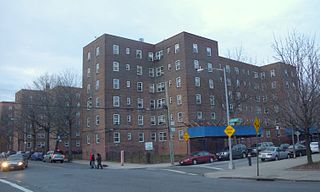
The Farragut Houses is a public housing project located in the downtown neighborhood of northwestern Brooklyn, New York City, bordering the Brooklyn Navy Yard. Farragut Houses is a property of New York City Housing Authority (NYCHA). The houses contain 3,272 residents who reside in ten buildings that are each 13 to 14 stories high.
