Related Research Articles

Hydrology is the scientific study of the movement, distribution, and management of water on Earth and other planets, including the water cycle, water resources, and environmental watershed sustainability. A practitioner of hydrology is called a hydrologist. Hydrologists are scientists studying earth or environmental science, civil or environmental engineering, and physical geography. Using various analytical methods and scientific techniques, they collect and analyze data to help solve water related problems such as environmental preservation, natural disasters, and water management.

The water cycle, also known as the hydrologic cycle or the hydrological cycle, is biogeochemical cycle that describes the continuous movement of water on, above and below the surface of the Earth. The mass of water on Earth remains fairly constant over time but the partitioning of the water into the major reservoirs of ice, fresh water, saline water and atmospheric water is variable depending on a wide range of climatic variables. The water moves from one reservoir to another, such as from river to ocean, or from the ocean to the atmosphere, by the physical processes of evaporation, condensation, precipitation, infiltration, surface runoff, and subsurface flow. In doing so, the water goes through different forms: liquid, solid (ice) and vapor.

Environmental degradation is the deterioration of the environment through depletion of resources such as quality of air, water and soil; the destruction of ecosystems; habitat destruction; the extinction of wildlife; and pollution. It is defined as any change or disturbance to the environment perceived to be deleterious or undesirable.
The Byrd Polar and Climate Research Center (BPCRC) is a polar, alpine, and climate research center at The Ohio State University founded in 1960.
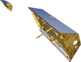
The Gravity Recovery and Climate Experiment (GRACE) was a joint mission of NASA and the German Aerospace Center (DLR). Twin satellites took detailed measurements of Earth's gravity field anomalies from its launch in March 2002 to the end of its science mission in October 2017. The Gravity Recovery and Climate Experiment Follow-On (GRACE-FO) is a continuation of the mission on near-identical hardware, launched in May 2018.
The Global Earth Observation System of Systems (GEOSS) was built by the Group on Earth Observations (GEO) on the basis of a 10-Year Implementation Plan running from 2005 to 2015. GEOSS seeks to connect the producers of environmental data and decision-support tools with the end users of these products, with the aim of enhancing the relevance of Earth observations to global issues. GEOSS aims to produce a global public infrastructure that generates comprehensive, near-real-time environmental data, information and analyses for a wide range of users. The Secretariat Director of Geoss is Barbara Ryan.
The Cooperative Institute for Research in Environmental Sciences (CIRES) is a research institute that is sponsored jointly by the National Oceanic and Atmospheric Administration (NOAA) Office of Oceanic and Atmospheric Research (OAR) and the University of Colorado Boulder (CU). CIRES scientists study the Earth system, including the atmosphere, hydrosphere, cryosphere, biosphere, and geosphere, and communicate these findings to decision makers, the scientific community, and the public.

Groundwater recharge or deep drainage or deep percolation is a hydrologic process, where water moves downward from surface water to groundwater. Recharge is the primary method through which water enters an aquifer. This process usually occurs in the vadose zone below plant roots and, is often expressed as a flux to the water table surface. Groundwater recharge also encompasses water moving away from the water table farther into the saturated zone. Recharge occurs both naturally and through anthropogenic processes, where rainwater and or reclaimed water is routed to the subsurface.
Geographic information systems (GISs) have become a useful and important tool in the field of hydrology to study and manage Earth's water resources. Climate change and greater demands on water resources require a more knowledgeable disposition of arguably one of our most vital resources. Because water in its occurrence varies spatially and temporally throughout the hydrologic cycle, its study using GIS is especially practical. Whereas previous GIS systems were mostly static in their geospatial representation of hydrologic features, GIS platforms are becoming increasingly dynamic, narrowing the gap between historical data and current hydrologic reality.

Surface water is water located on top of the Earth's surface, and may also be referred to as blue water. In common usage, it is usually used specifically for terrestrial (inland) waterbodies, the vast majority of which is produced by precipitation and runoff from nearby higher areas. As the climate warms in the spring, snowmelt runs off towards nearby streams and rivers contributing towards a large portion of human drinking water. Levels of surface water lessen as a result of evaporation as well as water moving into the ground becoming ground-water. Alongside being used for drinking water, surface water is also used for irrigation, wastewater treatment, livestock, industrial uses, hydropower, and recreation. It is recorded by the Environmental Protection Agency (EPA), that approximately 68 percent of water provided to communities comes from surface water. For USGS water-use reports, surface water is considered freshwater when it contains less than 1,000 milligrams per liter (mg/L) of dissolved solids.
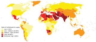
Water scarcity is the lack of fresh water resources to meet the standard water demand. Two types of water scarcity have been defined: physical or economic water scarcity. Physical water scarcity is where there is not enough water to meet all demands, including that needed for ecosystems to function effectively. Arid areas often suffer from physical water scarcity. On the other hand, economic water scarcity is caused by a lack of investment in infrastructure or technology to draw water from rivers, aquifers, or other water sources, or insufficient human capacity to satisfy the demand for water. Much of Sub-Saharan Africa is characterized by economic water scarcity.
James S. (Jay) Famiglietti is the director of the Global Institute for Water Security at the University of Saskatchewan in Saskatoon, Canada. Prior to that he was the Senior Water Scientist at NASA Jet Propulsion Laboratory in Pasadena, CA and a professor of Earth System Science at the University of California, Irvine. He is a leading expert in global water issues and in raising awareness about the global water crisis and in particular, about global groundwater depletion.
The global freshwater model WaterGAP calculates flows and storages of water on all continents of the globe, taking into account the human influence on the natural freshwater system by water abstractions and dams. It supports understanding the freshwater situation across the world’s river basins during the 20th and the 21st century, and is applied to assess water scarcity, droughts and floods and to quantify the impact of human actions on freshwater. Modelling results of WaterGAP have contributed to international assessment of the global environmental situation including the UN World Water Development Reports, the Millennium Ecosystem Assessment, the UN Global Environmental Outlooks as well as to reports of the Intergovernmental Panel on Climate Change. They were included in the 2012 Environmental Performance Index which ranks countries according to their environmental performance.
Aquaveo is a modeling software company based in Provo, Utah that develops software used to model and simulate groundwater, watershed, and surface water resources. Its main software products include SMS, GMS, WMS, and Arc Hydro Groundwater.
BAITSSS is biophysical Evapotranspiration (ET) computer model that determines water use, primarily in agriculture landscape, using remote sensing-based information. It was developed and refined by Ramesh Dhungel and the water resources group at University of Idaho's Kimberly Research and Extension Center since 2010. It has been used in different areas in the United States including Southern Idaho, Northern California, northwest Kansas, and Texas.
Petra Döll is a German hydrologist whose work focuses on modeling global water resources. She is a professor of hydrology and researcher at the Institute of Physical Geography, Goethe University Frankfurt.
Jeff Dozier is an American snow hydrologist, environmental scientist, researcher and academic. He is Distinguished Professor Emeritus and Founding Dean of the Bren School of Environmental Science & Management at the University of California, Santa Barbara.
Bridget Rosaleen Scanlon is an Irish and American hydrogeologist known for her work on groundwater depletion and groundwater recharging, and of the effects of climate change and land usage patterns on groundwater. She is a senior research scientist in the Bureau of Economic Geology at the University of Texas at Austin, where she is head of the Sustainable Water Resources Program. Her research has included the use of GRACE satellite data to compare drought conditions in Texas and California.
Amir AghaKouchak is an Iranian American civil engineer, academic and researcher. He is a Professor of Civil Engineering, Environmental Engineering, and Earth System Science at University of California, Irvine.
Isabella Velicogna is a geoscientist known for her work using gravity measurements from space to study changes in the polar ice sheets and water storage on Earth.
References
- ↑ Global warming: a rise in river flows raises alarm
- ↑ University of California Center for Hydrologic Modeling
- ↑ Water Crisis Looms For A Thirsty Planet
- ↑ Groundwater dropping globally
- ↑ UCI study: Groundwater vanishing in Central Valley
- ↑ Satellite Studies Reveal Groundwater Depletion around the World
- ↑ Sounding the alarm
- ↑ Earth System Science
- ↑ Department of Civil and Environmental Engineering
- ↑ The Movie
- ↑ O.C. Science
- ↑ PositiveH2O
- ↑ FreeWaters
