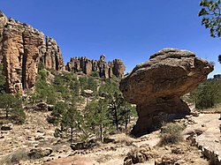
A balancing rock, also called a balanced rock, precariously balanced rock (PBR), or precarious boulder, is a naturally occurring geological formation featuring a large rock or boulder, sometimes of substantial size, resting on other rocks, bedrock, or on glacial till. Some formations known by this name only appear to be balancing, but are in fact firmly connected to a base rock by a pedestal or stem.
No single scientific definition of the term exists, and it has been applied to a variety of rock features.
Types of feature that the term has been applied to include:
India
Australia
Vietnam
Myanmar
Canada
United States
Mexico
Argentina
In geology, a boulder is a rock fragment with size greater than 25.6 cm (10.1 in) in diameter. Smaller pieces are called cobbles and pebbles. While a boulder may be small enough to move or roll manually, others are extremely massive. In common usage, a boulder is too large for a person to move. Smaller boulders are usually just called rocks or stones.
Karlu Karlu / Devils Marbles Conservation Reserve is a protected area in the Northern Territory of Australia located in the locality of Warumungu about 105 km (65 mi) south of Tennant Creek, and 393 km (244 mi) north of Alice Springs. The nearest settlement is the small town of Wauchope located 9 km (5.6 mi) to the south. The hamlet of Wycliffe Well is located 25 km (16 mi) to the south.
The exposed geology of the Yosemite area includes primarily granitic rocks with some older metamorphic rock. The first rocks were laid down in Precambrian times, when the area around Yosemite National Park was on the edge of a very young North American continent. The sediment that formed the area first settled in the waters of a shallow sea, and compressive forces from a subduction zone in the mid-Paleozoic fused the seabed rocks and sediments, appending them to the continent. Heat generated from the subduction created island arcs of volcanoes that were also thrust into the area of the park. In time, the igneous and sedimentary rocks of the area were later heavily metamorphosed.
A hoodoo is a tall, thin spire of rock formed by erosion. Hoodoos typically consist of relatively soft rock topped by harder, less easily eroded stone that protects each column from the elements. They generally form within sedimentary rock and volcanic rock formations.
Grand Coulee is an ancient river bed in the U.S. state of Washington. This National Natural Landmark stretches for about 60 miles (100 km) southwest from Grand Coulee Dam to Soap Lake, being bisected by Dry Falls into the Upper and Lower Grand Coulee.
A glacial erratic is a glacially deposited rock differing from the type of rock native to the area in which it rests. Erratics, which take their name from the Latin word errare, are carried by glacial ice, often over distances of hundreds of kilometres. Erratics can range in size from pebbles to large boulders such as Big Rock in Alberta.
The exposed geology of the Death Valley area presents a diverse and complex set of at least 23 formations of sedimentary units, two major gaps in the geologic record called unconformities, and at least one distinct set of related formations geologists call a group. The oldest rocks in the area that now includes Death Valley National Park are extensively metamorphosed by intense heat and pressure and are at least 1700 million years old. These rocks were intruded by a mass of granite 1400 Ma and later uplifted and exposed to nearly 500 million years of erosion.
A mushroom rock, also called rock pedestal, or a pedestal rock, is a naturally occurring rock whose shape, as its name implies, resembles a mushroom. The rocks are deformed in a number of different ways: by erosion and weathering, glacial action, or from a sudden disturbance. Mushroom rocks are related to, but different from, yardang.
The Stawamus Chief, officially Stawamus Chief Mountain, is a granitic dome located adjacent to the town of Squamish, British Columbia, Canada. It towers over 700 m (2,297 ft) above the waters of nearby Howe Sound. It is one of the largest granite monoliths in the world.
Plucking, also referred to as quarrying, is a glacial phenomenon that is responsible for the weathering and erosion of pieces of bedrock, especially large "joint blocks". This occurs in a type of glacier called a "valley glacier". As a glacier moves down a valley, friction causes the basal ice of the glacier to melt and infiltrate joints (cracks) in the bedrock. The freezing and thawing action of the ice enlarges, widens, or causes further cracks in the bedrock as it changes volume across the ice/water phase transition, gradually loosening the rock between the joints. This produces large chunks of rock called joint blocks. Eventually these joint blocks come loose and become trapped in the glacier.
Rocking stones are large stones that are so finely balanced that the application of just a small force causes them to rock. Typically, rocking stones are residual corestones formed initially by spheroidal weathering and have later been exposed by erosion or glacial erratics left by retreating glaciers. Natural rocking stones are found throughout the world. A few rocking stones might be man-made megaliths.
Tripod Rock is a glacial erratic, in this specific case a balancing rock, or perched boulder, located in Kinnelon, New Jersey in the Pyramid Mountain Natural Historic Area. This multi-ton Precambrian gneiss boulder, located near the edge of a long ridge, is balanced on three smaller boulders. Tripod Rock is roughly 6 m (20 ft) long, 3 m (9.8 ft) wide, and 2.5 m high, weighing approximately 127 tonnes (280,000 lb). A triangular crest runs the length of its top. The boulder is balanced on three smaller stones roughly 1 m in diameter that raise it above the bedrock by about 0.5 m at its lowest point. The point of contact between the boulder and its support stones forms an approximate 3-4-5 triangle.
Sims Corner Eskers and Kames National Natural Landmark of Douglas County, Washington and nearby McNeil Canyon Haystack Rocks and Boulder Park natural landmarks contain excellent examples of Pleistocene glacial landforms. Sims Corner Eskers and Kames National Natural Landmark includes classic examples of ice stagnation landforms such as glacial erratics, terminal moraines, eskers, and kames. It is located on the Waterville Plateau of the Columbia Plateau in north central Washington state in the United States.
The Monoliths, also known as Agassiz Rock, is a 116-acre (47 ha) park in Manchester-by-the-Sea, Massachusetts, owned and maintained by The Trustees of Reservations. The park's name is from two examples of large glacial erratic boulders plucked from bedrock. As glaciers scoured this landscape, the mass of bedrock forming the hill proved more resistant than the surrounding soil, forcing the bottom of the glacier up and over the hill. The north side was smoothed and the south side left steep and rugged as the glacier broke off chunks of rock as it passed.
Dropstones are isolated fragments of rock found within finer-grained water-deposited sedimentary rocks or pyroclastic beds. They range in size from small pebbles to boulders. The critical distinguishing feature is that there is evidence that they were not transported by normal water currents, but rather dropped in vertically through the air or water column, such as during a volcanic eruption.
Boulder Park National Natural Landmark, of Douglas County, Washington, along with the nearby McNeil Canyon Haystack Rocks and Sims Corner Eskers and Kames natural landmarks, illustrate well-preserved examples of classic Pleistocene ice stagnation landforms that are found in Washington. These landforms include numerous glacial erratics and haystack rocks that occur near and on the Withrow Moraine, which is the terminal moraine of the Okanogan ice lobe.
New England is a region in the North Eastern United States consisting of the states Rhode Island, Connecticut, Massachusetts, New Hampshire, Vermont, and Maine. Most of New England consists geologically of volcanic island arcs that accreted onto the eastern edge of the Laurentian Craton in prehistoric times. Much of the bedrock found in New England is heavily metamorphosed due to the numerous mountain building events that occurred in the region. These events culminated in the formation of Pangaea; the coastline as it exists today was created by rifting during the Jurassic and Cretaceous periods. The most recent rock layers are glacial conglomerates.
Glacial erratic boulders of Snohomish County are large glacial erratic boulders of rock which were moved to Snohomish County, Washington by glacial action during previous ice ages.