
Grand Canyon National Park, located in northwestern Arizona, is the 15th site in the United States to have been named as a national park. The park's central feature is the Grand Canyon, a gorge of the Colorado River, which is often considered one of the Wonders of the World. The park, which covers 1,217,262 acres of unincorporated area in Coconino and Mohave counties, received more than 4.7 million recreational visitors in 2023. The Grand Canyon was designated a World Heritage Site by UNESCO in 1979. The park celebrated its 100th anniversary on February 26, 2019.

The Grand Canyon is a steep-sided canyon carved by the Colorado River in Arizona, United States. The Grand Canyon is 277 miles (446 km) long, up to 18 miles (29 km) wide and attains a depth of over a mile.

Lees Ferry is a site on the Colorado River in Coconino County, Arizona in the United States, about 7.5 miles (12.1 km) southwest of Page and 9 miles (14 km) south of the Utah–Arizona state line.

U.S. Route 89 is a north–south United States Numbered Highway with two sections, and one former section. The southern section runs for 848 miles (1,365 km) from Flagstaff, Arizona, to the southern entrance of Yellowstone National Park. The northern section runs for 404 miles (650 km) from the northern entrance of Yellowstone National Park in Montana, ending at the Canadian border. Unnumbered roads through Yellowstone connect the two sections. Before 1992, US 89 was a Canada–Mexico, border-to-border highway that ended at Nogales, Arizona, on its southern end.

Navajo Bridge is the name of twin steel spandrel arch bridges that cross the Colorado River in the Grand Canyon National Park in northern Coconino County, Arizona, United States. The newer of the two spans carries vehicular traffic on U.S. Route 89A (US 89A) over Marble Canyon between Bitter Springs and Jacob Lake, allowing travel into a remote Arizona Strip region north of the Colorado River including the North Rim of Grand Canyon National Park.

Marble Canyon is the section of the Colorado River canyon in northern Arizona from Lee's Ferry to the confluence with the Little Colorado River, which marks the beginning of the Grand Canyon.

Grant is an unincorporated community and a U.S. Post Office in Park County, Colorado, United States.

Parshall is an unincorporated town, a post office, and a census-designated place (CDP) located in and governed by Grand County, Colorado, United States. The Parshall post office has the ZIP Code 80468. At the United States Census 2020, the population of the Parshall CDP was 42.

U.S. Route 89A is a 91.74-mile (147.64 km) north–south auxiliary U.S. highway in southwestern Kane County, Utah and northeastern Coconino County, Arizona in the southwestern United States. The highway is an old routing of U.S. Route 89 from Bitter Springs, Arizona to Kanab, Utah. The state of Arizona has designated this highway the Fredonia-Vermilion Cliffs Scenic Road. The highway is used to access the North Rim of Grand Canyon National Park and is known for the Navajo Bridge. Until 2008, the Utah portion was signed State Route 11. The route provides the only direct road connection between the Arizona Strip and the rest of Arizona.

Chiriaco Summit is a small unincorporated community and travel stop located along Interstate 10 in the Colorado Desert of Southern California. It lies 19 miles (31 km) west of Desert Center on the divide between the Chuckwalla Valley and the Salton Sea basin at an elevation of 1,706 feet (520 m).

The Arizona Strip is the part of Arizona lying north of the Colorado River. Despite being larger in area than several U.S. states, the entire region has a population of fewer than 10,000 people. Consisting of northeastern Mohave County and northwestern Coconino County, the largest settlements in the Strip are Colorado City, Fredonia, and Beaver Dam, with smaller communities of Scenic, Littlefield and Desert Springs. The Kaibab Indian Reservation lies within the region. Lying along the North Rim of the Grand Canyon creates physical barriers to the rest of Arizona. Only three major roads traverse the region, I-15 crosses the northwestern corner while Arizona State Route 389 and U.S. Route 89A crosses the northeastern part of the strip, US 89A crosses the Colorado River via the Navajo Bridge, providing the only direct road connection between the strip and the rest of the state. The nearest metropolitan area is the St. George, Utah metro area, to which the region is more connected than to the rest of Arizona.

The Vermilion Cliffs are the second "step" up in the five-step Grand Staircase of the Colorado Plateau, in northern Arizona and southern Utah in the southwestern United States. They extend west from near Page, Arizona, for a considerable distance, in both Arizona and Utah.

Meadview is an unincorporated community and census-designated place (CDP) in Mohave County, Arizona, United States, located near Lake Mead. As of the 2020 census, Meadview had 1,420 residents, up from 1,224 as of 2010. It was founded in the 1960s as a retirement community and is still largely one, as well as a vacation spot for people coming to enjoy Lake Mead.

Jacob Lake is a small unincorporated community on the Kaibab Plateau in Coconino County, Arizona, United States, at the junction of U.S. Route 89A and State Route 67. Named after the Mormon explorer Jacob Hamblin, the town is known as the "Gateway to the Grand Canyon" because it is the starting point of Route 67, the only paved road leading to the North Rim of the Grand Canyon some 44 miles (71 km) to the south. The town itself consists of the Jacob Lake Inn which maintains motel rooms and cabins, a restaurant, lunch counter, gift shop, bakery, and general store; a gas station/garage; campground; and a visitors center run by the U.S. Forest Service. In the summer months, there is also a nearby center for horse rides.
U.S. Route 89 (US 89) is a U.S. Highway in the U.S. state of Arizona that begins in Flagstaff and heads north to the Utah border northwest of Page. US 89 is among the first U.S. Highways established in Arizona between November 11, 1926 and September 9, 1927. Until 1992, US 89 started at the international border in Nogales and was routed through Tucson, Phoenix and Prescott between Nogales and Flagstaff. State Route 79 and State Route 89 are both former sections of US 89.

Scenic is an unincorporated community and census-designated place (CDP) in Mohave County in extreme northwestern Arizona, United States. As of the 2020 census, its population was 1,321, down from 1,643 in 2010.

The Kanab Plateau is a 45-mile long plateau located at the north of the Grand Canyon in Arizona, United States. The plateau is adjacent west of the Kaibab Plateau of the North Rim, with a basin containing the Kanab Creek watershed in between. The basin is the site of the Kanab Creek Wilderness, with Snake Gulch at its north perimeter, and at the base of the Kanab Plateau, forming its southeast border.

The Colorado River is a major river of the western United States and northwest Mexico in North America. Its headwaters are in the Rocky Mountains where La Poudre Pass Lake is its source. Located in north central Colorado it flows southwest through the Colorado Plateau country of western Colorado, southeastern Utah and northwestern Arizona where it flows through the Grand Canyon. It turns south near Las Vegas, Nevada, forming the Arizona–Nevada border in Lake Mead and the Arizona–California border a few miles below Davis Dam between Laughlin, Nevada and Needles, California before entering Mexico in the Colorado Desert. Most of its waters are diverted into the Imperial Valley of Southern California. In Mexico its course forms the boundary between Sonora and Baja California before entering the Gulf of California. This article describes most of the major features along the river.
The Marble Canyon Dam, also known as the Redwall Dam, was a proposed dam on the Colorado River in Arizona. The dam was intended to impound a relatively small reservoir in the central portion of Marble Canyon to develop hydroelectric power. Plans centered on two sites between miles 30 and 40 in the canyon. At one point a 38-mile (61 km) tunnel was proposed to a site just outside Grand Canyon National Park to develop the site's full power generation potential, reducing the Colorado River to a trickle through the park.
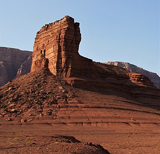
Cathedral Rock is a 3,942-foot-elevation (1,202 m) pillar located within Glen Canyon National Recreation Area, in Coconino County of northern Arizona. It is situated less than one mile northwest of Navajo Bridge, and three miles (4.8 km) southwest of Lee's Ferry and the confluence of the Paria and Colorado Rivers, where it towers over 400 feet (120 m) above the surrounding terrain as a landmark of the area. It can be seen from nearby U.S. Route 89A (US 89A) at Marble Canyon. This geographical feature's name was bestowed prior to 1900, and officially adopted in 1969 by the U.S. Board on Geographic Names.


