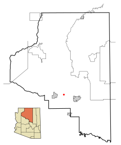
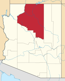
Parks, Arizona | |
---|---|
Coordinates: 35°17′29″N111°57′32″W / 35.29139°N 111.95889°W | |
Country | United States |
State | Arizona |
County | Coconino |
Area | |
• Total | 169.92 sq mi (440.09 km2) |
• Land | 169.90 sq mi (440.03 km2) |
• Water | 0.02 sq mi (0.06 km2) |
Elevation | 7,304 ft (2,226 m) |
Population (2020) | |
• Total | 1,382 |
• Density | 8.13/sq mi (3.14/km2) |
Time zone | UTC-7 (MST) |
ZIP code | 86018 |
Area code | 928 |
FIPS code | 04-53350 |
GNIS feature ID | 2409033 [4] |
Website | www |
Parks is a census-designated place (CDP) in Coconino County, Arizona, United States. The population was 1,188 at the 2010 census. [5]
According to the United States Census Bureau, the CDP has a total area of 172.4 square miles (446.4 km2), of which 172.3 square miles (446.3 km2) is land and 0.02 square miles (0.06 km2), or 0.01%, is water. [6]
Census | Pop. | Note | %± |
---|---|---|---|
2020 | 1,382 | — | |
U.S. Decennial Census [7] |
As of the census [8] of 2000, there were 1,137 people, 462 households, and 342 families residing in the CDP. The population density was 6.6 inhabitants per square mile (2.5/km2). There were 918 housing units at an average density of 5.3 per square mile (2.0/km2). The racial makeup of the CDP was 93.7% White, 0.4% Black or African American, 0.7% Native American, 0.4% Asian, 0.5% Pacific Islander, 1.8% from other races, and 2.6% from two or more races. 5.2% of the population were Hispanic or Latino of any race.
There were 462 households, out of which 29.2% had children under the age of 18 living with them, 63.6% were married couples living together, 5.8% had a female householder with no husband present, and 25.8% were non-families. 18.6% of all households were made up of individuals, and 5.4% had someone living alone who was 65 years of age or older. The average household size was 2.46 and the average family size was 2.78.
In the CDP, the age distribution of the population shows 22.6% under the age of 18, 3.9% from 18 to 24, 29.2% from 25 to 44, 34.3% from 45 to 64, and 10.0% who were 65 years of age or older. The median age was 43 years. For every 100 females, there were 109.0 males. For every 100 females age 18 and over, there were 106.6 males.
The median income for a household in the CDP was $39,886, and the median income for a family was $45,000. Males had a median income of $34,500 versus $27,875 for females. The per capita income for the CDP was $19,377. About 6.4% of families and 9.2% of the population were below the poverty line, including 9.6% of those under age 18 and 5.7% of those age 65 or over.
Parks is served by the Maine Consolidated Elementary School District.
Parks is located along Interstate 40.
Nazlini is a census-designated place (CDP) in Apache County, Arizona, United States. The population was 489 at the 2010 census. Nearby are Nazlini Creek and Nazlini Canyon. Nazlini Canyon is the site of many Native American ruins and campsites that were abandoned when erosion made them unusable.
Sawmill is a census-designated place (CDP) in Apache County, Arizona, United States. Sawmill is a part of Fort Defiance Agency, which is on the Navajo Nation. The population was 748 at the 2010 census. It is named after and developed around a sawmill. A trading post has been present since 1907.
Tsaile is a census-designated place (CDP) in Apache County, Arizona, United States, on the Navajo Nation. The population was 1,205 at the 2010 census.
LeChee is a census-designated place (CDP) in Coconino County, Arizona, United States. The population was 1,443 at the 2010 census.
Moenkopi is a census-designated place (CDP) in Coconino County, Arizona, United States, adjacent to the southeast side of Tuba City off U.S. Route 160. The population was 964 at the 2010 census.
Munds Park is an unincorporated census-designated place (CDP) in Coconino County, Arizona, United States. The year round population was 631 at the 2010 census.
Tonalea is a census-designated place (CDP) in Coconino County, Arizona, United States. The population was 549 at the 2010 census. It has also been known as Red Lake.
Tusayan is a town located in Coconino County, Arizona, United States. It was incorporated in 2010. A resort town near the south entrance to Grand Canyon National Park. The population was 558 at the 2010 census.
Winslow West is a census-designated place (CDP) in Navajo and Coconino counties in Arizona, United States. The population was 438 at the 2010 census. The entire community is off-reservation trust land belonging to the Hopi Tribe of Arizona. It lies just west of the city of Winslow, and is more than 50 km (31 mi) south of the main Hopi Reservation.
Pine is an unincorporated community and census-designated place (CDP) in Gila County, Arizona, United States. The population was 1,953 at the 2020 census. Pine was established by four Mormon families in 1879.
Sun Lakes is an unincorporated community and census-designated place (CDP) in Maricopa County, Arizona, United States. The population was 14,868 at the 2020 census. Sun Lakes is an active adult community comprising five country club communities in three homeowner associations. These include the gated communities of Oakwood and IronWood (IronOaks), the gated and non-gated communities of Palo Verde and Cottonwood, and the non-gated community of Sun Lakes 1.
Desert Hills is an unincorporated community and census-designated place (CDP) in Mohave County, Arizona, United States. The population was 2,764 at the 2020 census, up from 2,245 at the 2010 census.
Shongopovi is a census-designated place (CDP) in Navajo County, Arizona, United States. It is located on the Second Mesa, within the Hopi Reservation.
Shonto is a census-designated place (CDP) in Navajo County, Arizona, United States, in the Navajo Nation. The population was 591 at the 2010 census.
Vail is a census-designated place (CDP) in Pima County, Arizona, United States. It is 24 miles (39 km) southeast of Tucson. The population was 10,208 at the 2010 census, up from 2484 in the 2000 census. The area is known for the nearby Colossal Cave, a large cave system, and the Rincon Mountains District of Saguaro National Park, a top tourism spot within Arizona.
Affton is an unincorporated community and census-designated place (CDP) in south St. Louis County, Missouri, United States, near St. Louis. The population was 20,417 at the 2020 United States Census.
Wanamassa is an unincorporated community and census-designated place (CDP) within Ocean Township, in Monmouth County, New Jersey, United States. As of the 2020 census, the CDP's population was 4,344. The community was named for Wanamassa, a Native American leader of the 17th century.
Holiday City-Berkeley is an unincorporated community and census-designated place (CDP) located within Berkeley Township, in Ocean County, in the U.S. state of New Jersey. As of the 2010 United States Census, the CDP's population was 13,884.
Park Layne is a census-designated place (CDP) in Bethel Township, Clark County, Ohio, United States. The population of the CDP was 4,248 at the 2020 census. It is part of the Springfield, Ohio Metropolitan Statistical Area. Park Layne became a CDP in the 1980 United States Census.
Eastchester is a census-designated place (CDP) in Westchester County, New York, United States. The population was 19,554 at the 2010 census. The Eastchester CDP consists of the Town of Eastchester excluding the villages of Bronxville and Tuckahoe.