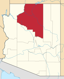
Blue Ridge, Arizona

Last updated

Blue Ridge, Arizona
USA Arizona location map.svg
Red pog.svg
Blue Ridge
Usa edcp location map.svg
Red pog.svg
Blue Ridge
Coordinates: 34°38′08″N111°09′18″W / 34.63556°N 111.15500°W / 34.63556; -111.15500
CountryUnited States
State Arizona
County Coconino
Area
[1]
  Total19.09 sq mi (49.46 km2)
  Land19.09 sq mi (49.46 km2)
  Water0.00 sq mi (0.00 km2)
Elevation
[2]
6,805 ft (2,074 m)
Population
 (2020)
  Total594
  Density31.11/sq mi (12.01/km2)
Time zone UTC-7 (MST)
  Summer (DST) UTC-6 (MDT)
ZIP Code
86024 (Happy Jack)
FIPS code 04-06997
GNIS feature ID2805211 [2]

Blue Ridge is an unincorporated community and census-designated place (CDP) in Coconino County, Arizona, United States. It was first listed as a CDP prior to the 2020 census.

Demographics

Historical population
CensusPop.Note
2020 594
U.S. Decennial Census [3]

Related Research Articles

<span class="mw-page-title-main">McNary, Arizona</span> CDP in Apache and Navajo Counties, Arizona

McNary is a census-designated place (CDP) in Apache and Navajo counties in the U.S. state of Arizona, on the Fort Apache Indian Reservation. The population was 528 at the 2010 census.

<span class="mw-page-title-main">Bitter Springs, Arizona</span> Census-designated place in Coconino County, Arizona

Bitter Springs is a native village and census-designated place (CDP) on the Navajo Nation in Coconino County, Arizona, United States. As of the 2020 census, the CDP population was 364

<span class="mw-page-title-main">Supai, Arizona</span> CDP in Coconino County, Arizona

Supai is a census-designated place (CDP) in Coconino County, Arizona, United States, within the Grand Canyon.

<span class="mw-page-title-main">Winslow West, Arizona</span> CDP in Coconino County, Arizona

Winslow West is a census-designated place (CDP) in Coconino and Navajo counties in Arizona, United States. The population was 438 at the 2010 census. The entire community is off-reservation trust land belonging to the Hopi Tribe of Arizona. It lies just west of the city of Winslow, and is more than 50 km (31 mi) south of the main Hopi Reservation.

<span class="mw-page-title-main">Peridot, Arizona</span> CDP in Gila and Graham Counties, Arizona, US

Peridot is an unincorporated community and census-designated place (CDP) in Gila and Graham counties in the U.S. state of Arizona. The population was 1,350 at the 2010 census.

<span class="mw-page-title-main">Peach Springs, Arizona</span> CDP in Mohave County, Arizona

Peach Springs is a census-designated place (CDP) in Mohave County, Arizona, United States. The population was 1,098 at the 2020 census. Peach Springs serves as the administrative headquarters of the Hualapai people and is located on the Hualapai Reservation.

<span class="mw-page-title-main">Spring Valley, Arizona</span> CDP in Yavapai County, Arizona

Spring Valley is a census-designated place (CDP) in Yavapai County, Arizona, United States. The population was 1,019 at the 2000 census.

<span class="mw-page-title-main">Evans, Georgia</span> Place in Georgia, United States

Evans is an unincorporated community and census-designated place (CDP) in Columbia County, Georgia, United States. It is a suburb of Augusta and is part of the Augusta metropolitan area. The population was 29,011 at the 2010 census, up from 17,727 at the 2000 census.

<span class="mw-page-title-main">Metairie, Louisiana</span> Census-designated place in Louisiana, United States

Metairie is a census-designated place (CDP) in Jefferson Parish, Louisiana, United States, and is part of the New Orleans metropolitan area. With a population of 143,507 in 2020, Metairie is the largest community in Jefferson Parish and was the fifth-largest CDP in the United States. It is an unincorporated area that would have been Louisiana's fourth-largest city behind Shreveport if incorporated.

<span class="mw-page-title-main">Blue Ridge, Virginia</span> Census-designated place in Virginia, United States

Blue Ridge is a census-designated place (CDP) in southern Botetourt County, Virginia, United States. The population was 3,185 at the 2020 census. The CDP is located along U.S. Route 460. It is part of the Roanoke Metropolitan Statistical Area.

Laymantown is a census-designated place (CDP) in southern Botetourt County, Virginia, United States. The population was 1,867 at the 2020 census. The community is located along State Route 658. It is part of the Roanoke Metropolitan Statistical Area.

<span class="mw-page-title-main">Ashburn, Virginia</span> Census-designated place in Virginia, United States

Ashburn is a rapidly growing census-designated place (CDP) in Loudoun County, Virginia, United States. At the 2010 United States census, its population was 43,511, up from 3,393 in 1990. It is 30 miles (48 km) northwest of Washington, D.C., and part of the Washington metropolitan area.

<span class="mw-page-title-main">Blue Ridge Summit, Pennsylvania</span> Census-designated place in Pennsylvania, United States

Blue Ridge Summit is an unincorporated community and census-designated place in Franklin County, Pennsylvania, United States, southwest of Gettysburg in the central part of the state, adjoining Pennsylvania's southern border with Maryland. It is less than 3 miles (5 km) east of Pen Mar, Maryland. The population of Blue Ridge Summit was 887 at the 2020 census.

<span class="mw-page-title-main">Linville, North Carolina</span> Census-designated place in North Carolina, United States

Linville is an unincorporated community and census-designated place (CDP) in Avery County, North Carolina, United States. It was first listed as a CDP in the 2020 census with a population of 283. Centered just south of US 221 and NC 105, the community is known as a summer mountain resort and host of the Grandfather Mountain Highland Games, the largest modern Highland games events in North Carolina.

<span class="mw-page-title-main">Sanders, Arizona</span> CDP in Apache County, Arizona

Sanders is a census-designated place (CDP) in Apache County, Arizona, United States. Sanders is located at the junction of U.S. Route 191 and Interstate 40. As of the 2020 census, it had a population of 575.

<span class="mw-page-title-main">Tamassee, South Carolina</span> Human settlement in Oconee County, South Carolina, US

Tamassee is an unincorporated community and census-designated place (CDP) located in northwestern Oconee County, South Carolina, United States. It was first listed as a CDP in the 2020 census with a population of 60.

Blue Ridge Shores is a census-designated place (CDP) in Louisa County, Virginia, United States. The population as of the 2020 census was 801. It was built beginning in 1960 as a resort community around Lake Louisa.

<span class="mw-page-title-main">Mesa del Caballo, Arizona</span> CDP in Gila County, Arizona

Mesa del Caballo is a census-designated place (CDP) in Gila County, Arizona, United States. The population was 765 at the 2010 census.

The Cliffs Valley is a resort community and census-designated place (CDP) in Greenville County, South Carolina, United States. It was first listed as a CDP prior to the 2020 census with a population of 736.

Whitney is an unincorporated area and census-designated place (CDP) adjacent to the city of Spartanburg in Spartanburg County, South Carolina, United States. It was first listed as a CDP prior to the 2020 census with a population of 4,409.

References

  1. "2020 U.S. Gazetteer Files". United States Census Bureau. Retrieved October 29, 2021.
  2. 1 2 U.S. Geological Survey Geographic Names Information System: Blue Ridge, Arizona
  3. "Census of Population and Housing". Census.gov. Retrieved June 4, 2016.