Mountain View Ranches, Arizona

Last updated

Mountain View Ranches, Arizona
USA Arizona location map.svg
Red pog.svg
Mountain View Ranches
Usa edcp location map.svg
Red pog.svg
Mountain View Ranches
Coordinates: 35°14′11″N111°28′19″W / 35.23639°N 111.47194°W / 35.23639; -111.47194
CountryUnited States
State Arizona
County Coconino
Area
[1]
  Total4.92 sq mi (12.74 km2)
  Land4.92 sq mi (12.74 km2)
  Water0.00 sq mi (0.00 km2)
Elevation
6,368 ft (1,941 m)
Population
 (2020)
  Total1,508
  Density306.69/sq mi (118.41/km2)
Time zone UTC-7 (MST)
  Summer (DST) UTC-6 (MDT)
ZIP Code
86004 (Flagstaff)
FIPS code 04-47925
GNIS feature ID2805221 [2]

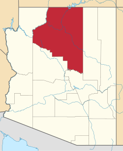
Mountain View Ranches is an unincorporated community and census-designated place (CDP) in Coconino County, Arizona, United States. It lies to the northeast of Flagstaff and was first listed as a CDP prior to the 2020 census.

Demographics

Historical population
CensusPop.Note
2020 1,508
U.S. Decennial Census [3]

Related Research Articles

<span class="mw-page-title-main">Denver metropolitan area</span> Metropolitan Statistical Area in Colorado, United States

Denver is the central city of a conurbation region in the U.S. state of Colorado. The conurbation includes one continuous region consisting of the six central counties of Adams, Arapahoe, Broomfield, Denver, Douglas, and Jefferson. The Denver region is part of the Front Range Urban Corridor.

<span class="mw-page-title-main">Stanford, California</span> Census-designated place in Santa Clara County, California, US

Stanford is a census-designated place (CDP) in the northwest corner of Santa Clara County, California, United States. It is the home of Stanford University. The population was 21,150 at the 2020 census.

<span class="mw-page-title-main">Air Force Academy, Colorado</span> Census Designated Place in State of Colorado, United States

The Air Force Academy is a census-designated place (CDP) located in El Paso County, Colorado, United States. The CDP includes the developed portion of the United States Air Force Academy, including the cadet housing facilities. The CDP is a part of the Colorado Springs, CO Metropolitan Statistical Area. The USAF Academy post office (ZIP Codes 80840 and 80841 serves the area. At the United States Census 2020, the population of the Air Force Academy CDP was 6,680.

<span class="mw-page-title-main">Westchester, Florida</span> Census-designated place in Florida

Westchester is a census-designated place (CDP) and neighborhood in Miami-Dade County, Florida. It is part of the Miami metropolitan area of South Florida. Prior to the 2020 U.S. Census, the neighboring University Park CDP was merged into Westchester CDP, effectively doubling its geography and population. Per the 2020 census, the population was 56,384.

<span class="mw-page-title-main">Candler-McAfee, Georgia</span> Place in Georgia, United States

Candler-McAfee is an unincorporated community and census-designated place (CDP) in DeKalb County, Georgia, United States. It is located east of Atlanta approximately 10 miles (16 km) east of Downtown Atlanta and to the south of Decatur, Georgia The population was 23,025 at the 2010 census.

<span class="mw-page-title-main">Redan, Georgia</span> Place in Georgia, United States

Redan is an unincorporated community and census-designated place (CDP) in DeKalb County, Georgia, United States. As of the 2020 census, the CDP had a total population of 31,749. It is a predominantly African American community in eastern DeKalb County, and is a suburb of Atlanta.

<span class="mw-page-title-main">Aiea, Hawaii</span> Census-designated place in Hawaii, United States

ʻAiea is a census-designated place (CDP) located in the City and County of Honolulu, Hawaii, United States. As of the 2010 Census, the CDP had a total population of 9,338.

<span class="mw-page-title-main">Waianae, Hawaii</span> Census-designated place in Honolulu County, Hawaii

Waianae or Waiʻanae is a census-designated place (CDP) in Honolulu County, Hawaii, United States. As of the 2020 census, the CDP population was 13,614.

<span class="mw-page-title-main">Harvey, Louisiana</span> Census-designated place in Louisiana, United States

Harvey is a census-designated place (CDP) in Jefferson Parish, Louisiana, United States. Harvey is on the south side of the Mississippi River, within the New Orleans–Metairie–Kenner metropolitan statistical area. The majority-minority population was 20,348 at the 2010 census, down from 22,226 at the 2000 census. The 2020 census determined 22,236 people lived in the CDP.

<span class="mw-page-title-main">Marrero, Louisiana</span> Census-designated place in Louisiana, United States

Marrero is a census-designated place (CDP) in Jefferson Parish, Louisiana, United States. Marrero is on the south side of the Mississippi River, within the New Orleans–Metairie–Kenner metropolitan statistical area. The population was 32,382 at the 2020 U.S. census.

<span class="mw-page-title-main">Uniondale, New York</span> Hamlet and census-designated place in New York, United States

Uniondale is a hamlet and census-designated place in Nassau County, New York, on Long Island, in the town of Hempstead. The population was 32,473 at the time of the 2020 census. Uniondale is home to Hofstra University's north campus, as well as a portion of its southern campus.

A census-designated place (CDP) is a concentration of population defined by the United States Census Bureau for statistical purposes only.

Lanham is an unincorporated community and census-designated place in Prince George's County, Maryland. As of the 2020 United States Census it had a population of 11,282. The New Carrollton station as well as an Amtrak station are across the Capital Beltway in New Carrollton, Maryland. Doctors Community Hospital is located in Lanham.

Peppermill Village is an unincorporated community near Maryland Route 214 in Prince George's County, Maryland, United States. Per the 2020 census, the population was 5,264. FedExField, Metrorail's Blue Line, and Hampton Mall shopping center are all located nearby. Because it is not formally incorporated, it has no official boundaries, but the United States Census Bureau has defined a census-designated place (CDP) consisting of Peppermill Village and the adjacent community of Carmody Hills, for statistical purposes.

<span class="mw-page-title-main">Devon, Pennsylvania</span> Census-designated place in Pennsylvania, United States

Devon is a census-designated place (CDP) located in Easttown township in Chester County, Pennsylvania, United States. The population was 1,515 at the 2010 census. The area is part of the Philadelphia Main Line suburbs.

University is a census-designated place (CDP) and unincorporated community in Orange County, Florida, United States, east of Orlando. The community is centered around the University of Central Florida and includes a location on its south side known as University Park. It is part of the Orlando–Kissimmee–Sanford, Florida Metropolitan Statistical Area. As of 2020, the CDP had a population of 45,284.

<span class="mw-page-title-main">Alafaya, Florida</span> Census-designated place in Florida, United States

Alafaya is a census-designated place and unincorporated area in Orange County, Florida, United States. The population was 92,452 at the 2020 US census. It is part of the Orlando–Kissimmee–Sanford, Florida Metropolitan Statistical Area. It is most known for being near the University of Central Florida, Avalon Park and Waterford Lakes.

Horizon West is a census-designated place (CDP) and unincorporated area in Orange County, Florida, United States. It is part of the Orlando–Kissimmee–Sanford, Florida Metropolitan Statistical Area. The population was 58,101 at the 2020 census.

References

  1. "2020 U.S. Gazetteer Files". United States Census Bureau. Retrieved October 29, 2021.
  2. 2805221
  3. "Census of Population and Housing". Census.gov. Retrieved June 4, 2016.