Apex, Arizona

Last updated

Apex, Arizona
Ghost town
USA Arizona location map.svg
Red pog.svg
Apex, Arizona
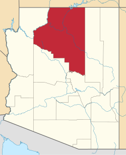
Location of Apex in Arizona
Coordinates: 35°56′35″N112°11′09″W / 35.94306°N 112.18583°W / 35.94306; -112.18583
Country United States
State Arizona
County Coconino
Elevation
[1]
6,594 ft (2,010 m)
Time zone UTC-7 (Mountain (MST))
  Summer (DST) UTC-7 (MST)
Area code 928
FIPS code 04-02970
GNIS feature ID 25248

Apex was a lumber town on the Grand Canyon Railway situated in Coconino County, Arizona. [2] Founded as company town on a wye on the Atlantic and Pacific Railroad, the community was dissolved when lumbering activity ceased in 1936.

Contents

Geography

Apex was located near the junction of Forest Service Road 335 and the rail line. [3]

History

Apex was a company town founded on a spur track of the Atlantic and Pacific Railroad in the late 1920s by the Saginaw and Manistee Lumber Company of Arizona, which built a headquarters for their milling operations. In addition to the headquarters building, the community originally consisted of "seven houses perched on the east slope and seven more and the school on the west, along with two oil tanks and a water tank for the locomotives." There were also several sheds and other buildings used to service the train and support mill operations. [4]

The houses in Apex rested on temporary foundations. The company maintained a commissary. [4]

Men without families would typically live in camps moving with the cutting activity, while families lived in a community at Apex station. [5] The settlement had its own school and telephone service. [5] Many of the workers and their families were from Sweden and Norway. [6] [5] Lumber operations by the Saginaw and Manistee Lumber Company ended in 1936 and it was abandoned. [5] [7]

Apex School District #3 opened in fall 1929 in a boxcar converted into a one-room schoolhouse. [4] The school at Apex, along with the neighboring one at the mining town of Anita, were at one time the only racially integrated schools in Arizona. [8] The school never exceeded 15 pupils, and closed in spring 1936. [4]

In May 1936, the community was disbanded when logging activities ceased. After removal, the houses were removed, leaving only the foundations. Shacks on boxcars were burned in bonfires. The schoolhouse was one of the last buildings in Apex; it, too, was removed. [4]

Northern Arizona University maintains the Apex, Arizona Archaeology Project, educating the public on life in Apex during the Great Depression. [9]

See also

Related Research Articles

<span class="mw-page-title-main">Flagstaff, Arizona</span> City in Arizona

Flagstaff is a city in, and the county seat of Coconino County, Arizona, in the southwestern United States. As of the 2020 United States census, the population was 76,831.

<span class="mw-page-title-main">Grand Canyon Village, Arizona</span> Town in Arizona, United States

Grand Canyon Village is a census-designated place (CDP) located on the South Rim of the Grand Canyon, in Coconino County, Arizona, United States. Its population was 2,004 at the 2010 Census. Located in Grand Canyon National Park, it is wholly focused on accommodating tourists visiting the canyon. Its origins trace back to the railroad completed from Williams, to the canyon's South Rim by the Santa Fe Railroad in 1901. Many of the structures in use today date from that period. The village contains numerous landmark buildings, and its historic core is a National Historic Landmark District, designated for its outstanding implementation of town design.

<span class="mw-page-title-main">Williams, Arizona</span> City in Coconino County, Arizona

Williams is a city in Coconino County, Arizona, United States, located west of Flagstaff. Its population was 3,023 at the 2010 census. It lies on the routes of Historic Route 66 and Interstate 40. It is also the southern terminus of the Grand Canyon Railway, which takes visitors to Grand Canyon Village.

<span class="mw-page-title-main">Valle, Arizona</span> Census-designated place in Arizona, US

Valle is a census-designated place in Coconino County, Arizona, United States. As of the 2010 US Census the population of Valle was 832. It lies at an altitude of 5,994 feet (1,827 m), at the junction of U.S. Route 180 and State Route 64. Its attractions include the Valle Airport (40G), the Planes of Fame Air Museum, and Birds of Prey, formally Bedrock City (Arizona), amusement park. Drivers often stop at the town on their way to the Grand Canyon from either Williams or Flagstaff, as it is approximately at the halfway point.

<span class="mw-page-title-main">Oak Creek Canyon</span> River gorge located in northern Arizona between the cities of Flagstaff and Sedona

Oak Creek Canyon is a river gorge located in northern Arizona between the cities of Flagstaff and Sedona. The canyon is often described as a smaller cousin of the Grand Canyon because of its scenic beauty. State Route 89A enters the canyon on its north end via a series of hairpin turns before traversing the bottom of the canyon for about 13 miles (21 km) until the highway enters the town of Sedona.

Happy Jack is an unincorporated community and campground located in the Mogollon Rim Region of Coconino County, Arizona, United States. The Lowell Discovery Telescope is located there. It is located on Lake Mary Road southeast of Flagstaff, Arizona.

<span class="mw-page-title-main">Drake, Arizona</span> Unincorporated community in the state of Arizona, United States

Drake was an unincorporated community on the Verde River in Yavapai County, Arizona, United States, and a station on the BNSF Railway's Phoenix Subdivision. Drake is also the junction and western terminus of the Verde Canyon Railroad. Drake is the site of the old Hell Canyon Bridge, formerly used by US Route 89, and now on the National Register of Historic Places.

The Flint and Pere Marquette Railroad (F&PM) is a defunct railroad which operated in the U.S. state of Michigan between 1857 and 1899. It was one of the three companies which merged to become the Pere Marquette Railway.

<span class="mw-page-title-main">Barney Flat Historic Railroad Logging Landscape</span> United States historic place

The Barney Flat Historic Railroad Logging Landscape is the historic remains of railroad logging on the South Kaibab Plateau in the early 20th century. Barney Flat is the only stump field on the US National Register of Historic Places. Barney Flat is located in the Kaibab National Forest, along the Perkinsville Road, south of Williams, Arizona. It was added to the National Register of Historic Places on February 24, 1995.

Grand Canyon High School is a public high school located near the Grand Canyon in Grand Canyon Village, Arizona. It is the only high school in the Grand Canyon Unified School District.

<span class="mw-page-title-main">Morse (community), Wisconsin</span> Unincorporated community in Wisconsin, United States

Morse is an unincorporated community located in the town of Gordon, Ashland County, Wisconsin, United States. Morse is located along the Bad River 7.5 miles (12.1 km) south-southeast of Mellen.

<span class="mw-page-title-main">Bright Angel Lodge</span> United States historic place

Bright Angel Lodge is a hotel complex at the South Rim of the Grand Canyon in Grand Canyon National Park, Arizona. Designed by architect Mary Jane Colter, the lodge is a complex of cabins around a central lodge building, directly on the edge of the canyon. The rustic lodge complex is a major contributing building in the Grand Canyon Village National Historic Landmark District. In 2022, Bright Angel Lodge is also a member of Historic Hotels of America, an official program of the National Trust for Historic Preservation.

<span class="mw-page-title-main">Pantano, Arizona</span> Ghost town in Arizona, United States

Pantano is a ghost town located in eastern Pima County, Arizona, between Benson and Vail. Access is via the Marsh Station Road interchange on I-10. It was established as a small railroad town with the arrival of the Southern Pacific in 1880, supplanting the earlier Ciénega station that was located to the west of Pantano.

Cosnino is a populated place situated in Coconino County, Arizona, United States, located several miles east of Flagstaff, the county seat.

Riordan was a populated place situated in Coconino County, Arizona, United States. It has an estimated elevation of 7,316 feet (2,230 m) above sea level.

Anita was a mining town situated in Coconino County, Arizona on the Grand Canyon Railway. It was named in 1897 after a railroad surveyor's daughter.

Nancy is a ghost town in Angelina County, in the U.S. state of Texas. It is located within the Lufkin, Texas micropolitan area.

References

  1. "Feature Detail Report for: Apex". Geographic Names Information System . United States Geological Survey, United States Department of the Interior.
  2. "Apex (in Coconino County, AZ) Populated Place Profile". AZ Hometown Locator. Archived from the original on January 25, 2016. Retrieved January 8, 2016.
  3. "Apex · Arizona". Apex · Arizona. Retrieved February 15, 2024.
  4. 1 2 3 4 5 Richmond, Al (1988). "Apex: A Vanished Arizona Logging Community". The Journal of Arizona History. 29 (1): 75–88. ISSN   0021-9053 via JSTOR.
  5. 1 2 3 4 Al Richmond (1986). "The Grand Canyon Railway: A History". The Journal of Arizona History. 27 (4): 425–438. JSTOR   41859703.
  6. Don Lago (2004). On the Viking Trail: Travels in Scandinavian America. University of Iowa Press. p.  105. ISBN   978-0877458920.
  7. Gerber, Rudy J (December 31, 1994). "History and Archaeology en Route". The Railroad and the Canyon. Pelican. p. 121. ISBN   978-1455610860.
  8. Michael F. Anderson (2005). A Gathering of Grand Canyon Historians: Ideas, Arguments, and First-person Accounts. Grand Canyon Association. ISBN   978-0938216834.
  9. "Apex, Arizona Archaeology Project". Northern Arizona University Anthropology. Archived from the original on October 2, 2023. Retrieved February 15, 2024.