Fort Valley, Arizona

Last updated

Fort Valley, Arizona
Southwest side of San Francisco Peaks (October 10, 2017) (37364879950).jpg
Coconino County Arizona Incorporated and Unincorporated areas Fort Valley Highlighted 0425045.svg
Location of Fort Valley in Coconino County, Arizona.
Usa edcp location map.svg
Red pog.svg
Fort Valley, Arizona
Location in the United States
Coordinates: 35°19′22″N111°44′23″W / 35.32278°N 111.73972°W / 35.32278; -111.73972
Country United States
State Arizona
County Coconino
Area
[1]
  Total72.45 sq mi (187.65 km2)
  Land72.45 sq mi (187.65 km2)
  Water0.00 sq mi (0.00 km2)
Elevation
[2]
8,376 ft (2,553 m)
Population
 (2020)
  Total1,682
  Density23.22/sq mi (8.96/km2)
Time zone UTC-7 (MST (no daylight saving time))
Area code 928
FIPS code 04-25045
GNIS feature ID2582786 [2]

Fort Valley is a census-designated place in the southern portion of Coconino County in the state of Arizona, United States. Fort Valley is located very close to the city of Flagstaff. The population as of 2010, was 779. [3]

Contents

History

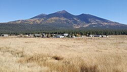
Fort Valley is a historical settlement at the base of Mt. Agassiz in Flagstaff, Arizona. It gained its name as a fort that was established to defend against Apache tribes although it was never actually used. Wagon trains migrating from the east came upon Flagstaff and settled here. Many of the old settlements can still be seen today. The primary motivation for this settlement was logging as was true for the rest of Flagstaff. The ponderosa pine forest supplied abundant amounts of timber which were then transported via railroad.

The first Fort Valley settlers were Laura and William Murphy in 1881, they belonged to the church of Jesus Christ of Latter Day Saints. After these first settlers many more followed. Eventually a small community was developed and Fort Valley became a ranching hub in northern Arizona. As ranching took hold in Fort Valley the effect on the environment was devastating. Water sources such as Leroux spring ran dark with silt and the land was becoming a victim of overgrazing. In 1908 Gustaf Adolf Pearson arrived in Fort Valley as a member of the forest service and began to revive the area.

Fort Valley was also a popular hub for the scientific community to collect data on recently obtained land in the Southwest. Because of the unique combination of a desert and a mountain environment the area was particularly interesting for geologists, paleontologists, and scientists alike.

Present

Fort Valley remains a settlement today. The suburb of Flagstaff Arizona still holds a number of small farms and ranches. The Leroux spring has been taken over by the city of Flagstaff and the city is considering it as a potential water source. Fort Valley remains a wide open meadow at the base of what is now Snowbowl Road. Much of the past wildlife such as deer, herons, and elk remain in the area.

Demographics

Historical population
CensusPop.Note
2020 1,682
U.S. Decennial Census [4]

Climate

According to the Köppen Climate Classification system, Fort Valley has a dry-summer humid continental climate, abbreviated "Dsb" on climate maps.

Climate data for Fort Valley, Arizona (1991–2020 normals, extremes 1909–2018)
MonthJanFebMarAprMayJunJulAugSepOctNovDecYear
Record high °F (°C)65
(18)
70
(21)
76
(24)
80
(27)
90
(32)
97
(36)
101
(38)
96
(36)
90
(32)
85
(29)
75
(24)
69
(21)
101
(38)
Mean maximum °F (°C)57.2
(14.0)
59.5
(15.3)
66.3
(19.1)
73.3
(22.9)
81.3
(27.4)
89.8
(32.1)
91.3
(32.9)
87.2
(30.7)
82.7
(28.2)
76.0
(24.4)
67.7
(19.8)
60.0
(15.6)
92.7
(33.7)
Mean daily maximum °F (°C)46.3
(7.9)
48.1
(8.9)
54.4
(12.4)
62.0
(16.7)
70.8
(21.6)
81.6
(27.6)
83.6
(28.7)
81.3
(27.4)
76.0
(24.4)
65.9
(18.8)
54.9
(12.7)
45.9
(7.7)
64.2
(17.9)
Daily mean °F (°C)31.6
(−0.2)
33.8
(1.0)
39.1
(3.9)
44.5
(6.9)
51.7
(10.9)
60.6
(15.9)
66.5
(19.2)
65.1
(18.4)
58.4
(14.7)
48.0
(8.9)
38.7
(3.7)
31.2
(−0.4)
47.4
(8.6)
Mean daily minimum °F (°C)16.9
(−8.4)
19.6
(−6.9)
23.7
(−4.6)
27.1
(−2.7)
32.7
(0.4)
39.6
(4.2)
49.3
(9.6)
49.2
(9.6)
40.8
(4.9)
30.1
(−1.1)
22.5
(−5.3)
16.4
(−8.7)
30.7
(−0.7)
Mean minimum °F (°C)−5.9
(−21.1)
−1.7
(−18.7)
5.7
(−14.6)
12.8
(−10.7)
19.9
(−6.7)
26.2
(−3.2)
34.6
(1.4)
36.2
(2.3)
25.9
(−3.4)
15.7
(−9.1)
3.8
(−15.7)
−4.9
(−20.5)
−9.1
(−22.8)
Record low °F (°C)−37
(−38)
−32
(−36)
−22
(−30)
−7
(−22)
6
(−14)
19
(−7)
25
(−4)
20
(−7)
11
(−12)
−9
(−23)
−16
(−27)
−30
(−34)
−37
(−38)
Average precipitation inches (mm)2.10
(53)
2.47
(63)
1.81
(46)
0.90
(23)
0.89
(23)
0.23
(5.8)
2.78
(71)
3.38
(86)
1.82
(46)
1.28
(33)
1.33
(34)
1.61
(41)
20.60
(523)
Average snowfall inches (cm)10.6
(27)
8.4
(21)
2.8
(7.1)
1.1
(2.8)
0.0
(0.0)
0.1
(0.25)
0.0
(0.0)
0.0
(0.0)
0.0
(0.0)
0.4
(1.0)
1.8
(4.6)
5.2
(13)
30.4
(77)
Average precipitation days (≥ 0.01 inch)7.68.66.64.54.22.211.213.17.54.84.56.881.6
Average snowy days (≥ 0.1 inch)3.33.61.00.60.00.00.00.00.00.30.61.611.0
Source: National Oceanic and Atmospheric Administration [5] [6]

See also

Related Research Articles

<span class="mw-page-title-main">Flagstaff, Arizona</span> City in Arizona

Flagstaff is the county seat of Coconino County, Arizona, in the southwestern United States. As of the 2020 United States census, the city's population was 76,831.

<span class="mw-page-title-main">Show Low, Arizona</span> City in Arizona, United States

Show Low is a city in Navajo County, Arizona. It lies on the Mogollon Rim in east central Arizona, at an elevation of 6,345 feet. The city was established in 1870 and incorporated in 1953. According to the 2010 census, the population of the city was 10,660.

<span class="mw-page-title-main">Buckeye, Arizona</span> City in Maricopa County, Arizona, United States

Buckeye is a city in Maricopa County, Arizona, United States. It is Arizona's largest city by area, and it is the westernmost suburb in the Phoenix Metropolitan Area. As of the 2020 census, the population was 91,502, up from 50,876 in 2010, and 6,537 in 2000. It was the fastest-growing city in the United States for 2017, 2018, and 2021.

<span class="mw-page-title-main">Glendale, Arizona</span> City in Arizona, United States

Glendale is a city in Maricopa County, Arizona, United States. Located about nine miles northwest of the state capital Phoenix, Glendale is known for State Farm Stadium, which is the home of the Arizona Cardinals football team. The city also contains the Arrowhead Towne Center shopping mall. As of the 2020 census, Glendale had a population of 248,325.

<span class="mw-page-title-main">Heber-Overgaard, Arizona</span> CDP in Navajo County, Arizona

Heber-Overgaard is a census-designated place (CDP) in Navajo County, Arizona, United States. Situated atop the Mogollon Rim, the community lies at an elevation of 6,627 feet (2,020 m). The population was 2,898 at the 2020 census. Heber and Overgaard are technically two unincorporated communities, but as of the 1990 census, their proximity led to the merged name of "Heber-Overgaard".

<span class="mw-page-title-main">Holbrook, Arizona</span> City in Navajo County, Arizona, US

Holbrook is a city in Navajo County, Arizona, United States. According to the 2010 census, the population of the city was 5,053. The city is the county seat of Navajo County.

<span class="mw-page-title-main">Camp Verde, Arizona</span> Town in Yavapai County, Arizona

Camp Verde is a town in Yavapai County, Arizona, United States. As of the 2010 census, the population of the town is 10,873.

<span class="mw-page-title-main">Escalante, Utah</span> City in Utah, United States

Escalante is a city in central Garfield County, Utah, United States, located along Utah Scenic Byway 12 (SR-12) in the south-central part of the state. As of the 2020 census, 786 people were living in the city.

<span class="mw-page-title-main">Kaibab National Forest</span> Protected area in northern Arizona

Kaibab National Forest borders both the north and south rims of the Grand Canyon, in north-central Arizona. Its 1.6 million acres is divided into three sections: the North Kaibab Ranger District, the Tusayan Ranger District, and the Williams Ranger District. It is managed by the United States Forest Service. Grand Canyon National Park separates the North Kaibab and the South Kaibab. The South Kaibab covers 1,422 square miles (3,680 km2) and the North Kaibab stretches over 1,010 square miles (2,600 km2). Elevations vary on the forest from 5,500 feet in the southwest corner to 10,418 feet at the summit of Kendrick Peak on the Williams Ranger District. The forest as a whole is headquartered in Williams.

<span class="mw-page-title-main">San Francisco Peaks</span> Mountain range in Arizona, United States

The San Francisco Peaks are a volcanic mountain range in the San Francisco volcanic field in north central Arizona, just north of Flagstaff and a remnant of the former San Francisco Mountain. The highest summit in the range, Humphreys Peak, is the highest point in the state of Arizona at 12,637 feet (3,852 m) in elevation. The San Francisco Peaks are the remains of an eroded stratovolcano. An aquifer within the caldera supplies much of Flagstaff's water while the mountain itself is in the Coconino National Forest, a popular recreation site. The Arizona Snowbowl ski area is on the western slopes of Humphreys Peak, and has been the subject of major controversy involving several tribes and environmental groups.

<span class="mw-page-title-main">Northern Arizona</span> Region of the US state of Arizona

Northern Arizona is an unofficial, colloquially-defined region of the U.S. state of Arizona. Generally consisting of Apache, Coconino, Mohave, Navajo, and Yavapai counties, the region is geographically dominated by the Colorado Plateau, the southern border of which in Arizona is called the Mogollon Rim.

<span class="mw-page-title-main">Arizona Strip</span> Part of Arizona north of the Colorado River

The Arizona Strip is the part of Arizona lying north of the Colorado River. Despite being larger in area than several U.S. states, the entire region has a population of fewer than 10,000 people. Consisting of northeastern Mohave County and northwestern Coconino County, the largest settlements in the Strip are Colorado City, Fredonia, and Beaver Dam, with smaller communities of Scenic, Littlefield and Desert Springs. The Kaibab Indian Reservation lies within the region. Lying along the North Rim of the Grand Canyon creates physical barriers to the rest of Arizona. Only three major roads traverse the region, I-15 crosses the northwestern corner while Arizona State Route 389 and U.S. Route 89A crosses the northeastern part of the strip, US 89A crosses the Colorado River via the Navajo Bridge, providing the only direct road connection between the strip and the rest of the state. The nearest metropolitan area is the St. George, Utah metro area, to which the region is more connected than to the rest of Arizona.

<span class="mw-page-title-main">Joseph City, Arizona</span> Unincorporated community in the state of Arizona, United States

Joseph City is a Census Designated Place located in Navajo County, Arizona, United States. It is located on Interstate 40, approximately eighty miles east of Flagstaff and about thirty-five miles west of Petrified Forest National Park. In 2010, there were 1,386 inhabitants.

<span class="mw-page-title-main">Geography of Nevada</span>

The landlocked U.S. state of Nevada has a varied geography and is almost entirely within the Basin and Range Province and is broken up by many north–south mountain ranges. Most of these ranges have endorheic valleys between them.

<span class="mw-page-title-main">Geography of Oregon</span> Overview of the Geography of Oregon

Oregon is 295 miles (475 km) north to south at longest distance, and 395 miles (636 km) east to west. With an area of 98,381 square miles (254,810 km2), Oregon is slightly larger than the United Kingdom. It is the ninth largest state in the United States. Oregon's highest point is the summit of Mount Hood, at 11,249 feet (3,429 m), and its lowest point is the sea level of the Pacific Ocean along the Oregon Coast. Oregon's mean elevation is 3,300 feet (1,006 m). Crater Lake National Park, the state's only national park, is the site of the deepest lake in the United States at 1,943 feet (592 m). Oregon claims the D River as the shortest river in the world, though the state of Montana makes the same claim of its Roe River. Oregon is also home to Mill Ends Park, the smallest park in the world at 452 square inches (0.29 m2).

<span class="mw-page-title-main">Geography of Arizona</span>

Arizona is a landlocked state situated in the southwestern region of the United States of America. It has a vast and diverse geography famous for its deep canyons, high- and low-elevation deserts, numerous natural rock formations, and volcanic mountain ranges. Arizona shares land borders with Utah to the north, the Mexican state of Sonora to the south, New Mexico to the east, and Nevada to the northwest, as well as water borders with California and the Mexican state of Baja California to the southwest along the Colorado River. Arizona is also one of the Four Corners states and is diagonally adjacent to Colorado.

<span class="mw-page-title-main">Lost Forest Research Natural Area</span> Protected area in the United States

The Lost Forest Research Natural Area is a designated forest created by the Bureau of Land Management to protect an ancient stand of ponderosa pine in the remote high desert county of northern Lake County, in the south central area of the U.S. state of Oregon. Lost Forest is an isolated area of pine trees separated from the nearest contiguous forest land by forty miles of arid desert. There are no springs or surface water in Lost Forest, and much of the southwest portion of the natural area is covered by large shifting sand dunes that are slowly encroaching on the forest.

<span class="mw-page-title-main">Bellemont, Arizona</span> Unincorporated community in Coconino County, Arizona, US

Bellemont is an unincorporated community in Coconino County, Arizona, United States, located along Interstate 40, about 11 miles (18 km) west-northwest of Flagstaff. At an elevation of 7,132 feet (2,174 m), it is claimed to be the highest settlement along historic Route 66. It was a known water stop due to its local springs. As of June 2012, it had an estimated population of 893.

<span class="mw-page-title-main">History of Flagstaff, Arizona</span> Review of the topic

Flagstaff is a city in, and the county seat of, Coconino County in northern Arizona, in the southwestern United States. Established as a modern settlement in 1876 and incorporated as a city in 1928, the land had previously been lived on by native peoples of the southwest, primarily the Sinagua. Mountaineer Antoine Leroux then traveled the area, with Edward Fitzgerald Beale following in his footsteps and establishing a trail through the city in the mid-1800s. With a local spring, a small settlement grew by the wagon road, and the town was dominated by the McMillan, Riordan, and Babbitt families. Focused on agricultural pursuits, these families constructed some historic red stone buildings that still stand today.

<span class="mw-page-title-main">Haigler Creek, Arizona</span> CDP in Gila County, Arizona

Haigler Creek is an unincorporated community and census-designated place (CDP) in northern Gila County, Arizona, United States. It lies at an elevation of 5,240 feet and is surrounded by the Tonto National Forest. As of the 2020 census, Haigler Creek had a population of 39 people.

References

  1. "2020 U.S. Gazetteer Files". United States Census Bureau. Retrieved October 29, 2021.
  2. 1 2 U.S. Geological Survey Geographic Names Information System: Fort Valley, Arizona
  3. "AZ – Fort Valley CDP". U.S. Census Bureau. Archived from the original on April 3, 2014. Retrieved April 3, 2014.
  4. "Census of Population and Housing". Census.gov. Retrieved June 4, 2016.
  5. "NOWData - NOAA Online Weather Data". National Oceanic and Atmospheric Administration . Retrieved August 14, 2022.
  6. "U.S. Climate Normals Quick Access – Station: Ft Valley, AZ". National Oceanic and Atmospheric Administration. Retrieved January 28, 2023.

Further reading

Commons-logo.svg Media related to Fort Valley, Arizona at Wikimedia Commons