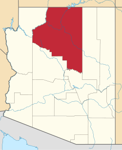
Chalender or Challender was a populated place in Coconino County, Arizona, United States. [1] It had a mainline railway station, [2] sawmill, [3] and school. [4] [5] It was located on the Atlantic and Pacific Railroad between Williams and Bellemont.
Coconino County is a county located in the north-central part of the U.S. state of Arizona. Its population was 134,421 at the 2010 census. The county seat is Flagstaff. The county takes its name from Cohonino, a name applied to the Havasupai people. It is the second-largest county by area in the contiguous United States, behind San Bernardino County, California. It has 18,661 sq mi (48,300 km2), or 16.4% of Arizona's total area, and is larger than each of the nine smallest states in the U.S.
Yavapai County is near the center of the U.S. state of Arizona. As of the 2020 census, its population was 236,209, making it the fourth-most populous county in Arizona. The county seat is Prescott.
Cameron is a census-designated place (CDP) in Coconino County, Arizona, United States. The population was 885 at the 2010 census. Most of the town's economy is tourist food and craft stalls, restaurants, and other services for north–south traffic from Flagstaff and Page. There is a ranger station supplying information and hiking permits for the Navajo Nation as well as a small selection of books for sale. There is also a large craft store run by the Nation itself; most vendors in the area operate from small private stalls. It is named after Ralph H. Cameron, Arizona's first senator.
Fredonia is a town in Coconino County, Arizona, United States. As of the 2010 census it had a population of 1,314. Fredonia is the gateway to the North Rim of the Grand Canyon.
Kaibab is a census-designated place (CDP) in Coconino and Mohave counties in the U.S. state of Arizona. It is coterminous with the Kaibab Indian Reservation. The population was 124 at the 2010 census.
Kaibeto is a census-designated place (CDP) in Coconino County, Arizona, United States. The population was 1,522 at the 2010 census.
Supai is a census-designated place (CDP) in Coconino County, Arizona, United States, within the Grand Canyon.
Tusayan is a town, but was a census-designated place during the 2010 census. It is located in Coconino County, Arizona, United States. It was incorporated in 2010. A resort town near the south entrance to Grand Canyon National Park, Tusayan is served by Grand Canyon National Park Airport. The population was 558 at the 2010 census.
Williams is a city in Coconino County, Arizona, United States, located west of Flagstaff. Its population was 3,023 at the 2010 census. It lies on the routes of Historic Route 66 and Interstate 40. It is also the southern terminus of the Grand Canyon Railway, which takes visitors to Grand Canyon Village. There are numerous inns, motels, restaurants and gas stations catering to the large influx of tourists rather than local residents, especially during the summer and holiday seasons.
Winslow West is a census-designated place (CDP) in Coconino and Navajo counties in Arizona, United States. The population was 438 at the 2010 census. The entire community is off-reservation trust land belonging to the Hopi tribe. It lies just west of the city of Winslow, and more than 50 km (31 mi) south of the main Hopi reservation.
Sun City is an unincorporated community and census-designated place in Maricopa County, Arizona, United States, that is located within the Phoenix metropolitan area.
Sun City West is an unincorporated community and census-designated place (CDP) in Maricopa County, Arizona, United States. The population was 24,535 at the 2010 census.
The Coconino Plateau is found south of the Grand Canyon and north-northwest of Flagstaff, in northern Arizona of the Southwestern United States.
There are several lakes named Mud Lake in the U.S. state of Arizona:
The Grand Cañon Forest Reserve was established by the General Land Office in Arizona on February 20, 1893 with 1,851,250 acres (7,491.7 km2). It was renamed Grand Canyon on August 8, 1906 and transferred to the U.S. Forest Service becoming a National Forest on March 4, 1907. On July 1, 1908 the entire forest was divided between Coconino National Forest and the newly established Kaibab National Forest, while other areas were returned to public lands, and the name was discontinued.
The Coconino Association for Vocations, Industry and Technology is a joint technological education district in Coconino County, Arizona. Established in 2001, it is one of Arizona's eleven such districts. It receives funding from the state and secondary property taxes in the association's five member districts: the Flagstaff Unified School District, Fredonia-Moccasin Unified School District, Grand Canyon Unified School District, Page Unified School District, and the Williams Unified School District.
Corn Creek Wash is a stream located in Coconino County, Arizona, southeast of the census-designated place of Leupp. The name was collected by the United States Geological Survey between 1976 and 1980, and entered into the Geographic Names Information System on February 8, 1980.
Dennison was a stop on the Atchison, Topeka and Santa Fe Railway between Canyon Diablo, and Winslow, Arizona, United States, in Coconino County. Formerly in Yavapai County, it came to be in Coconino County upon the latter's creation in 1891. Dennison was named for a railroad roadmaster named Denny.
Fort Tuthill is a former National Guard training facility and a county park situated in Coconino County, Arizona. It has an estimated elevation of 6,995 feet (2,132 m) above sea level. The fort is listed on the National Register of Historic Places.
Indian Gardens is a populated place situated on the east side of Oak Creek Canyon, in Coconino County, Arizona, United States, north of Sedona. It has an estimated elevation of 4,603 feet (1,403 m) above sea level.
Coordinates: 35°14′04″N112°01′31″W / 35.23444°N 112.02528°W