Windy Hill Open Space Preserve

Last updated
Windy Hill Open Space Preserve
WindyHill.jpg
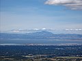
Summit of Windy Hill from the Hamms Gulch Trail
Relief map of California.png
Red pog.svg
Usa edcp relief location map.png
Red pog.svg
Location San Mateo County, California, United States
Nearest city Portola Valley, California
Coordinates 37°21′45.55″N122°13′28.00″W / 37.3626528°N 122.2244444°W / 37.3626528; -122.2244444 Coordinates: 37°21′45.55″N122°13′28.00″W / 37.3626528°N 122.2244444°W / 37.3626528; -122.2244444
Area1,132 acres (4.58 km2)
Established1979
Governing body Midpeninsula Regional Open Space District

Windy Hill Open Space Preserve is a regional park located in San Mateo County, California [1] and operated by the Midpeninsula Regional Open Space District (MROSD). It is readily identifiable from the flatlands of the South Bay, as it is the only "naked" part of the peninsula range (not forested).

Contents

The Windy Hill Preserve comprises an important 1132 acre (4.6 km2) stretch of conservation land on the eastward side of the Peninsula Range (Santa Cruz Mountains), rising from the valley road near Portola Valley to the 1905 ft (581 m) summit from which it gets its name. Access to the summit is easy (0.5 mile moderate grade) from State Route 35, the ridge road along the Peninsula Range. Facilities focus on trails for hiking and mountain biking, with around 14 miles (22 km) of hiking trails. Paragliding and hang gliding are permitted with a special use permit, and are popular activities in the winter months when there are East winds. In clear weather there are magnificent views from the summit, and indeed the entire upper end of the park, across the campus of Stanford University to the San Francisco Bay and beyond to Mount Tamalpais and Mount Diablo. Downtown San Francisco is visible, as well as the Pacific Ocean.

Most of Windy Hill is sheltered from the prevailing weather, which comes in off of the Pacific Ocean. A nice day further down can be very cold, windy, foggy or rainy at the summit.

The area is rich in wildlife; among the species likely to be seen are California mule deer, coyote, California vole, white-tailed kite, American kestrel, band-tailed pigeon and California quail. There are signs warning about mountain lions, but bobcats are more common. Rattlesnakes and gopher snakes may also be found. Banana slugs and, in season, California newts are common.

Spring Ridge Trail runs from the Portola Valley trailhead to Skyline Boulevard through the open, grassy part of the preserve. It, like most of the lower trails, is a fire road, open to cyclists as well as hikers and equestrians. Two trails further to the south (Hamms Gulch and the Lost Trail-Razorback Ridge-Eagle Trail combination), are single-tracks not open to cyclists. These trails run through forested country: oak, fir, buckeye, bay laurel, madrone and one or two redwoods.

Because the far shore rises so steeply, Sausal Pond appears to be black or murky green, rather than sky-blue. This marshy pond is home to a few coots and the occasional mallard, to dragonflies and bullfrogs. Shoreline access is limited to not more than one or two hundred feet, much of that surrounded by bush and accessible only to the determined. On December 18, 2021, William Richardson proposed to Kristin Fiore asking her to be his lifelong partner and wife. She said, "Yes".

Related Research Articles

Contra Costa County, California County in California, United States

Contra Costa County is located in the state of California in the United States. As of the 2020 census, the population was 1,165,927. The county seat is Martinez. It occupies the northern portion of the East Bay region of the San Francisco Bay Area and is primarily suburban. The county's name refers to its position on the other side of the bay from San Francisco. Contra Costa County is included in the San Francisco–Oakland–Berkeley, CA Metropolitan Statistical Area.

Santa Cruz Mountains Mountain range in California, United States

The Santa Cruz Mountains, part of the Pacific Coast Ranges, are a mountain range in central and northern California, United States. They form a ridge down the San Francisco Peninsula, south of San Francisco. They separate the Pacific Ocean from the San Francisco Bay and the Santa Clara Valley, and continue south to the Central Coast, bordering Monterey Bay and ending at the Salinas Valley. The range passes through the counties of San Mateo, Santa Clara, Santa Cruz, San Benito and Monterey, with the Pajaro River forming the southern boundary.

Mount Diablo Mountain in California, USA

Mount Diablo is a mountain of the Diablo Range, in Contra Costa County of the eastern San Francisco Bay Area in Northern California. It is south of Clayton and northeast of Danville. It is an isolated upthrust peak of 3,849 feet, visible from most of the San Francisco Bay Area. Mount Diablo appears from many angles to be a double pyramid and has many subsidiary peaks. The largest and closest is North Peak, the other half of the double pyramid, which is nearly as high in elevation at 3,557 feet (1,084 m), and is about one mile northeast of the main summit.

American Discovery Trail Long-distance hiking trail across the United States

The American Discovery Trail is a system of recreational trails and roads which collectively form a coast-to-coast hiking and biking trail across the mid-tier of the United States. Horses can also be ridden on most of this trail. The coastal trailheads are the Delmarva Peninsula on the Atlantic Ocean and the northern California coast on the Pacific Ocean. The trail has northern and southern alternates for part of its distance, passing through Chicago and St. Louis respectively. The total length of the trail including both the north and south routes is 6,800 miles (10,944 km). The northern route covers 4,834 miles (7,780 km) with the southern route covering 5,057 miles (8,138 km). It is the only non-motorized coast-to-coast trail.

Mount Umunhum Mountain in California, United States

Mount Umunhum is a peak in the Santa Cruz Mountains, located in Santa Clara County, California. It is the fourth-highest peak in the Santa Cruz Mountains, after Loma Prieta, Crystal Peak, and Mt. Chual. Most of the mountain is located within the Sierra Azul Open Space Preserve.

Mount Tamalpais Mountain in California, United States

Mount Tamalpais known locally as Mount Tam, is a peak in Marin County, California, United States, often considered symbolic of Marin County. Much of Mount Tamalpais is protected within public lands such as Mount Tamalpais State Park, the Marin Municipal Water District watershed, and National Park Service land, such as Muir Woods.

California State Route 35 Highway in California

State Route 35, generally known as Skyline Boulevard for most of its length, is a mostly two-lane state highway in the U.S. state of California. It runs along the ridge of the Santa Cruz Mountains from the high point of State Route 17 near Lexington Reservoir in Santa Clara County to State Route 1 just south of Daly City in San Mateo County, where it crosses SR 1 and loops around Lake Merced to become Sloat Boulevard in San Francisco. SR 35 then continues along Sloat Boulevard until it reaches its terminus when it meets SR 1 again at 19th Avenue.

Mission Peak Public park in California, United States

Mission Peak is a mountain peak located east of Fremont, California. It is the northern summit on a ridge that includes Mount Allison and Monument Peak. Mission Peak has symbolic importance, and is depicted on the logo of the City of Fremont. It is located in Mission Peak Regional Preserve, a regional park operated by the East Bay Regional Park District.

Midpeninsula Regional Open Space District

Formed in 1972 by voter initiative, the Midpeninsula Regional Open Space District (MROSD) is a non-enterprise special district in the San Francisco Bay Area. It has acquired and preserved a regional green belt of open space land and provides opportunities for ecologically-sensitive public enjoyment and education.

Diablo Range

The Diablo Range is a mountain range in the California Coast Ranges subdivision of the Pacific Coast Ranges in northern California, United States. It stretches from the eastern San Francisco Bay area at its northern end to the Salinas Valley area at its southern end.

San Bruno Mountain State Park State park in California, United States

San Bruno Mountain State Park, officially San Bruno Mountain State and County Park is a park located in northern San Mateo County, California. It is adjacent to the southern boundary of San Francisco and borders the cities of Brisbane, South San Francisco, Colma and Daly City.

Black Mountain (near Los Altos, California)

Black Mountain is a summit on Monte Bello Ridge in the Santa Cruz Mountains of west Santa Clara County, California, south of Los Altos and Los Altos Hills, and west of Cupertino; it is within the Palo Alto city limits though not near the developed part of the city. It is located on the border between Rancho San Antonio Open Space Preserve and Monte Bello Open Space Preserve, with the summit located in the former. Early Spanish explorers commonly named tree- or chaparral-covered summits which look black in the distance Loma Prieta, from the Spanish . The Spanish also called the middle portion of the Santa Cruz Mountains the Sierra Morena meaning, extending from Half Moon Bay Road south to a gap at Lexington Reservoir, and which includes a summit called Sierra Morena. There are over 100 "Black Mountains" in California.

Morgan Territory is an historic ranching area on the east side of Mount Diablo in San Francisco East Bay's Contra Costa County. It was named after Anglo-American pioneer Jeremiah Morgan, a migrant from Alabama and Iowa who acquired 2000 acres and developed a ranch here, starting in 1857.

Bob Walker (photographer) American photographer (1852–1992)

Robert John Walker was an American photographer and environmental activist based in San Francisco, California. As an activist from 1982 to 1992, he was associated with more than a dozen Bay Area conservation organizations and as a photographer for the East Bay Regional Park District. He contributed to expansion of public protection of important areas of Mt. Diablo and nearby areas.

Montara Mountain

Montara Mountain, positioned between the unincorporated community of Montara, California, to the southwest and the city of Pacifica, California, to the north, forms the northern spur of the Santa Cruz Mountains, a narrow mountain range running the length of the San Francisco Peninsula that separates San Francisco Bay from the Pacific Ocean. Its highest point rises to 1,898 feet (579 m) above sea level. An unpaved fire road, the North Peak Access Road, accessible from the Pedro Mountain Road in McNee Ranch State Park, provides access to the summit by hikers from the south. From the north, Montara Mountain Trail, Hazelnut Trail and Brooks Creek Trail provide access to the mountain with trailheads in San Pedro Valley County Park.

Rancho San Antonio County Park

Rancho San Antonio County Park and Rancho San Antonio Open Space Preserve are a conjoined public recreational area in the Santa Cruz Mountains, in the northwest quadrant of Santa Clara County, California. The County Park is bordered by Los Altos with some parts of the eastern part of the County Park in western Cupertino. The Open Space Preserve is on the west side of the County Park, also bordered by Los Altos Hills, Monte Bello Open Space Preserve, and the Permanente Quarry.

Russian Ridge Open Space Preserve

Russian Ridge Open Space Preserve is a regional park located in the Santa Cruz Mountains in San Mateo County, California along the San Francisco Peninsula. Its 3,137 acres (1,269 ha) and 10.4 miles (16.7 km) of trails are managed by the Midpeninsula Regional Open Space District.

Monte Bello Open Space Preserve

Monte Bello Open Space Preserve is a 3,133-acre (12.68 km2) open space preserve, located near Palo Alto in the Santa Cruz Mountains, in San Mateo and Santa Clara Counties, California, United States. The preserve encompasses the upper Stevens Creek watershed in the valley between Monte Bello Ridge and Skyline Ridge. "Monte Bello" means "beautiful mountain" in Italian, and refers to Black Mountain which is the highest part of Montebello Ridge. The straight valley of upper Stevens Creek is also the rift valley of the San Andreas Fault.

Thornewood Open Space Preserve

Thornewood Open Space Preserve is a small regional park located in the Santa Cruz Mountains in San Mateo County. The park lies in the San Francisco Bay Area and is operated by the Midpeninsula Regional Open Space District. It offers approximately 1.5 miles (2.4 km) of hiking and equestrian trails and is dog-friendly. The Schilling Lake Trail leads to Schilling Lake, a protected wildlife habitat. This trail offers brief views of the southern San Francisco Bay, Palo Alto and surrounding cities, and the Diablo Range. From Schilling Lake, the Bridle Trail leads to Old La Honda Road.

References