
The Santa Cruz Mountains are a mountain range in central and Northern California, United States, constituting a part of the Pacific Coast Ranges. They form a ridge down the San Francisco Peninsula, south of San Francisco. They separate the Pacific Ocean from the San Francisco Bay and the Santa Clara Valley, and continue south to the Central Coast, bordering Monterey Bay and ending at the Salinas Valley. The range passes through the counties of San Mateo, Santa Clara, and Santa Cruz, with the Pajaro River forming the southern boundary.

Año Nuevo State Park is a state park of California, United States, encompassing Año Nuevo Island and Año Nuevo Point, which are known for their pinniped rookeries. Located in San Mateo County, the low, rocky, windswept point juts out into the Pacific Ocean about 55 miles (89 km) south of San Francisco and the Golden Gate. Año Nuevo State Natural Reserve, formerly a separate unit of the California state park system, was merged into Año Nuevo State Park in October 2008. The coastal geographic center, or coastal-midpoint of California is located at the Northern end of this park at N 37°09′58″, W 122°21'40", as the absolute geographic center of California falls at N 37°09′58″, W 119°26′58″W.

Silicon Valley Monterey Bay Council (#055) is a Boy Scouts of America council headquartered in San Jose, California. It was the result of a council merger between the Santa Clara County Council and the Monterey Bay Area Council. In 2004, the previous two councils served over 11,000 youth in over 400 Boy Scout troops, Cub Scout packs, Venturing crews, and Explorer posts. In 2012, the Monterey Bay Area Council announced that after 89 years as a separate council, it had agreed to merge back into the Santa Clara County Council. As of 2013, the council served 13,000 youth in four different counties.
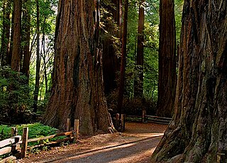
Big Basin Redwoods State Park is a state park in the U.S. state of California, located in Santa Cruz County, about 36 km (22 mi) northwest of Santa Cruz. The park contains almost all of the Waddell Creek watershed, which was formed by the seismic uplift of its rim, and the erosion of its center by the many streams in its bowl-shaped depression.
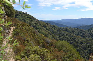
Castle Rock State Park is a 5,242-acre (2,121 ha) state park of California, United States, located along the crest of the Santa Cruz Mountains and almost entirely in Santa Cruz County, with parts extending into Santa Clara County and San Mateo County. It embraces coast redwood, Douglas fir, and madrone forest, most of which has been left in its wild, natural state. Steep canyons are sprinkled with unusual rock formations that are a popular rock climbing area. The park is named after a sandstone formation called Castle Rock. The forest here is lush and mossy, crisscrossed by 32 miles (51 km) of hiking trails. These trails are part of an even more extensive trail system that links the Santa Clara and San Lorenzo valleys with Castle Rock State Park, Big Basin Redwoods State Park, and the Pacific Coast. Due to its overnight parking lot, Castle Rock is a popular starting point for the Skyline-to-the-Sea Trail, a 30-mile (48 km) trail that begins near by at Saratoga Gap and leads to Waddell Beach north of Santa Cruz. There are two walk-in campgrounds within the park for overnight backpacking.
The San Lorenzo River is a 29.3-mile-long (47.2 km) river in the U.S. state of California. The name San Lorenzo derives from the Spanish language for "Saint Lawrence" due to its reported sighting on that saint's feast day by Spanish explorers. Its headwaters originate in Castle Rock State Park in the Santa Cruz Mountains and flow south by southeast through the San Lorenzo Valley before passing through Santa Cruz and emptying into Monterey Bay and the Pacific Ocean.

State Route 9 is a rural and mountainous state highway in the U.S. state of California that travels 35 miles (56 km) from SR 1 in Santa Cruz to SR 17 in Los Gatos, passing through the San Lorenzo Valley and the Saratoga Gap in the Santa Cruz Mountains.

State Route 35, generally known as Skyline Boulevard for most of its length, is a mostly two-lane state highway in the U.S. state of California. It runs along the ridge of the Santa Cruz Mountains from the high point of State Route 17 near Lexington Reservoir in Santa Clara County to State Route 1 just south of Daly City in San Mateo County, where it crosses SR 1 and loops around Lake Merced to become Sloat Boulevard in San Francisco. SR 35 then continues along Sloat Boulevard until it reaches its terminus when it meets SR 1 again at 19th Avenue.
Henry Cowell Redwoods State Park is a state park of California, United States, preserving mainly forest and riparian areas in the watershed of the San Lorenzo River, including a grove of old-growth coast redwood. It is located in Santa Cruz County, primarily in the area between the cities of Santa Cruz and Scotts Valley, near the community of Felton and the University of California at Santa Cruz. The park includes a non-contiguous extension in the Fall Creek area north of Felton. The 4,623-acre (1,871 ha) park was established in 1953.

Formed in 1972 by voter initiative, the Midpeninsula Regional Open Space District (MROSD) is a non-enterprise special district in the San Francisco Bay Area. It has acquired and preserved a regional green belt of open space land and provides opportunities for ecologically-sensitive public enjoyment and education.

Uvas Canyon County Park is a 1,147-acre (464 ha) natural park located in upper Uvas Canyon on the eastern side of the Santa Cruz Mountains, west of Morgan Hill, California. The park has several small waterfalls, some of which flow perennially, that feed into tributaries confluent with Uvas Creek. The park is part of the Santa Clara County Parks System, and facilitates picnics, hiking and overnight camping. It is one of the few parks in the area that allows dogs in the campgrounds.

Theodore J. Hoover Natural Preserve, which includes Waddell Marsh, is located at the mouth of Waddell Creek, a coastal freshwater marsh that is one of the rarest habitats on the Central Coast of California. This marsh is one of the few relatively undisturbed bodies of fresh water left along the West coast. The land is 23 acres of wetland habitat. It is part of the Rancho del Oso Big Basin Redwoods State Park, located approximately 65 miles south of San Francisco. The elevation in the park ranges from sea level to over 2,000 feet. The area was named after William W. Waddell, who established the last of his four sawmills there in 1868. The sawmill ran down after his death in 1875. All the boilers were left in the area; they are now completely surrounded by second-growth redwoods. Other trees found in the park are conifers, and oaks. Within the park there are different vegetation types to be seen, such as chaparral, redwood forests, and riparian habitats.
Sempervirens Fund, originally established in 1900 as Sempervirens Club, is California's oldest land trust. Founder Andrew P. Hill’s goal was to preserve the old-growth forest that became Big Basin Redwoods State Park, the first California state park in 1902. Sempervirens Fund's mission is to protect and permanently preserve coast redwood forests, wildlife habitat, watersheds, and other important natural features of California's Santa Cruz Mountains, and to encourage people to appreciate and enjoy this environment. Sempervirens Fund does this by purchasing land for protection and transferring it to state or local agencies. Sempervirens Fund has also worked to establish conservation easements and trail linkages between parks and coastal marine preserves. As of 2013, Sempervirens Fund has saved more than 34,000 acres of redwood lands.
Rancho Del Oso Nature and History Center interprets the cultural and natural history of the area of Rancho del Oso which became part of California's Big Basin Redwoods State Park, in the 1970s. The center is located on Highway 1 16 miles north of Santa Cruz, California.

Saratoga Gap Open Space Preserve is a 1540-acre regional park located near Saratoga Gap in the Santa Cruz Mountains of Santa Clara County, California. The preserve is owned and operated by the Midpeninsula Regional Open Space District. The preserve contains about 2 miles (3 km) of hiking trails, which are open to equestrians and bicycles.

Sanborn County Park is a 3,453 acre (13.97 km2) county park situated in the Santa Cruz Mountains, managed by the Santa Clara County Parks and Recreation Department. The deeply forested park features over 15 miles of trails, second-growth redwoods, and creeks that flow year-round. It offers hiking, RV camping, walk-in campsites, and picnicking/BBQ sites. In the summer months, Sanborn County Park hosts the only outdoor Shakespearean company in Silicon Valley.

Boulder Creek is a 7.9-mile-long (13 km) stream tributary of the San Lorenzo River in the U.S. state of California. Its drainage basin consists of approximately 11.3 square miles (29.3 km2) of Santa Cruz County. Its main stem begins high in the Santa Cruz Mountains in Big Basin Redwoods State Park. It flows generally south, through the Park and unincorporated community of Boulder Creek, before finally emptying into the San Lorenzo River in the community's downtown.
Monte Bello Open Space Preserve is a 3,133-acre (12.68 km2) open space preserve, located near Palo Alto in the Santa Cruz Mountains, in San Mateo and Santa Clara Counties, California, United States. The preserve encompasses the upper Stevens Creek watershed in the valley between Monte Bello Ridge and Skyline Ridge. "Monte Bello" means "beautiful mountain" in Italian, and refers to Black Mountain which is the highest part of Montebello Ridge. The straight valley of upper Stevens Creek is also the rift valley of the San Andreas Fault.

Long Ridge Open Space Preserve is a 2,035-acre (824 ha) open space preserve along Long Ridge in the Santa Cruz Mountains.

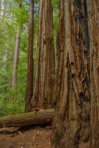
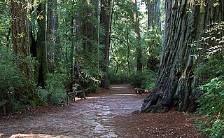
 The Skyline-to-the-Sea Trail passing through a fallen California Redwood tree.
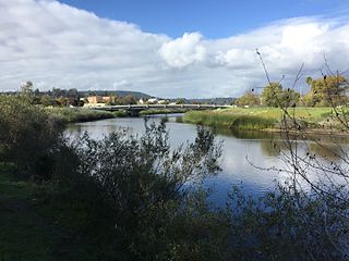
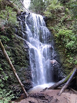
 The Skyline-to-the-Sea Trail passing over Waddell Creek.


