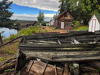
Isle Royale National Park is an American national park consisting of Isle Royale, along with more than 400 small adjacent islands and the surrounding waters of Lake Superior, in the state of Michigan.

The Appalachian Trail, also called the A.T., is a hiking trail in the Eastern United States, extending almost 2,200 miles (3,540 km) between Springer Mountain in Georgia and Mount Katahdin in Maine, and passing through 14 states. The Appalachian Trail Conservancy claims the Appalachian Trail to be the longest hiking-only trail in the world. More than three million people hike segments of the trail each year.

The John Muir Trail (JMT) is a long-distance trail in the Sierra Nevada mountain range of California, passing through Yosemite, Kings Canyon and Sequoia National Parks. It is named after John Muir, a naturalist.

Gateway National Recreation Area is a 26,607-acre (10,767 ha) U.S. National Recreation Area in New York City and Monmouth County, New Jersey. It provides recreational opportunities that are not commonly found in a dense urban environment, including ocean swimming, bird watching, boating, hiking and camping. More than 8.7 million people visited Gateway National Recreation Area in 2022, making it the fourth-most visited unit of the National Park Service.
Earl V. Shaffer, was an American outdoorsman and author known from 1948 as The Crazy One for attempting what became the first publicized claimed hiking trip in a single season over the entire length of the Appalachian Trail (AT). He also worked as a carpenter, a soldier specializing in radar and radio installation, and an antique dealer.

The Virgin Islands National Park is an American national park preserving about 60% of the land area of Saint John in the United States Virgin Islands, as well as more than 5,500 acres of adjacent ocean, and nearly all of Hassel Island, just off the Charlotte Amalie, Saint Thomas harbor.

The Superior Hiking Trail, also known as the SHT, is a 310-mile (500 km) long hiking trail in northeastern Minnesota that follows the rocky ridges overlooking Lake Superior for most of its length. The trail travels through forests of birch, aspen, pine, fir, and cedar. Hikers enjoy views of boreal forests, the Sawtooth Mountains, babbling brooks, rushing waterfalls, and abundant wildlife. The lowest point in the path is 602 ft (183 m) above sea level and the highest point is 1,829 ft (557 m) above sea level. The footpath is intended for hiking only. Motorized vehicles, mountain bikes, and horses are not allowed on the trail. Many people use the trail for long-distance hiking, and facilitating this purpose are 94 backcountry, fee-free campsites.

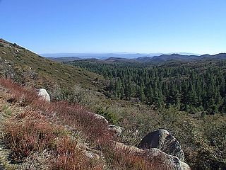
The Cleveland National Forest encompasses 460,000 acres/720 sq mi (1,900 km2) of inland montane regions—approx. 60 miles from the Pacific Ocean—within the counties of San Diego, Riverside, and Orange, California. The landscape varies somewhat, with mostly chaparral canyons, arroyos and high desert, but dotted with meadows and oak and conifer forests. Near water sources, riparian environments and perennial aquatic plants attract native and migratory wildlife, such as at San Diego’s man-made Lake Cuyamaca. A generally warm and dry, inland-Mediterranean climate prevails over the forest, with the cooler months producing morning frost and snowfall. It is the southernmost U.S. National Forest of California. The area is administered by the U.S. Forest Service, a government agency within the United States Department of Agriculture, and is locally overseen by the Descanso, Palomar and Trabuco Ranger Districts.

Two Harbors, colloquially known as "The Isthmus", is a small unincorporated community island village on the island of Santa Catalina Island, California, United States, with a population of 298. It is the second center of population on the island, besides the city of Avalon. It is mainly a resort village. It has only one restaurant, one hotel and one general store. The village has about 150 permanent residents who live on the isthmus year-round. One notable feature was the one-room schoolhouse which closed in 2014.

Catalina Airport is a privately owned airport located 6.4 miles (10.2 km) northwest of the central business district of Avalon, California, United States, in the middle of Catalina Island. The airport is open to the public and allows general aviation aircraft to land there. One-time landing fees are $38 for Piston single, $44 for Piston twin, $55 for Turbine single, $110 for Turbine twin. Overnight fees are $22 for a single engine or $27 twin engine. Operating hours are 8 a.m. – 5 p.m. The airport is primarily used for general aviation. The airport is also used for airfreight from the mainland. Supplies for the island are delivered daily.

The Catalina Island Conservancy is a nonprofit organization established to protect and restore Santa Catalina Island, California, United States. The Conservancy was established in 1972 through the efforts of the Wrigley and Offield families. The Conservancy was created when both families deeded 42,135 acres (170.51 km2) of the island over to the organization—88% of the Island.
The Appalachian National Scenic Trail spans 14 U.S. states over its roughly 2,200 miles (3,500 km): Georgia, North Carolina, Tennessee, Virginia, West Virginia, Maryland, Pennsylvania, New Jersey, New York, Connecticut, Massachusetts, Vermont, New Hampshire, and Maine. The southern end is at Springer Mountain, Georgia, and it follows the ridgeline of the Appalachian Mountains, crossing many of its highest peaks and running almost continuously through wilderness before reaching the northern end at Mount Katahdin, Maine.

The Kenai National Wildlife Refuge is a 1.92-million-acre (7,770 km2) wildlife habitat preserve located on the Kenai Peninsula of Alaska, United States. It is adjacent to Kenai Fjords National Park. This refuge was created in 1941 as the Kenai National Moose Range, but in 1980 it was changed to its present status by the Alaska National Interest Lands Conservation Act. The refuge is administered from offices in Soldotna.

Elkhorn Slough is a 7-mile-long (11 km) tidal slough and estuary on Monterey Bay in Monterey County, California. It is California's second largest estuary and the United States' first estuarine sanctuary. The community of Moss Landing and the Moss Landing Power Plant are located at the mouth of the slough on the bay.

The Backbone Trail is a long-distance trail extending 67.79 miles (109.10 km) across the length of the Santa Monica Mountains in the U.S. state of California. Its western terminus is Point Mugu State Park, and its eastern terminus is Will Rogers State Historic Park in Pacific Palisades. The trail is open to hikers throughout its length. Dogs, mountain bicyclists and horseback riders are only allowed on portions of the trail as posted.

Camp Cherry Valley was a summer camp on the leeward side of Catalina Island, California, which is owned and operated by the Greater Los Angeles Area Council of the Boy Scouts of America. It is located two coves north of Two Harbors at Cherry Cove. The camp, valley and cove get their name from the Catalina cherry trees native to the island. It also offers non-Scouting programs on a year-round basis.

Santa Catalina Island is a rocky island off the coast of Southern California in the Gulf of Santa Catalina. The island covers an area of about 75 square miles. It features a diverse and rugged landscape, including rolling hills, canyons, coastal cliffs, and sandy beaches. The island's highest peak is Mount Orizaba, rising to an elevation of 2,097 feet. The island is 22 mi long and 8 mi across at its largest width. The island is situated in the Pacific Ocean, approximately 29 mi south-southwest of Long Beach, California. Politically, Catalina Island is part of Los Angeles County in District 4. Most of the island's land is unincorporated and is thus governed by the county.

The Palos Verdes Peninsula Land Conservancy (PVPLC) is a non-profit organization that is based on the Palos Verdes Peninsula in southwestern Los Angeles County, California.

Newland Head Conservation Park is a protected area located in South Australia within the locality of Waitpinga on the southern coast of the Fleurieu Peninsula 91 km south of the centre of Adelaide, and 7 km southwest of Victor Harbor. Its name is taken from Newland Head that feature prominently at the eastern boundary of the park. The conservation park is classified as an IUCN Category III protected area.


