The Windy Gap Trail is a short but important link of the north San Gabriel River valley to the Pacific Crest Trail in the San Gabriel Mountains in California. The trailhead starts at the uppermost parking lot of the Crystal Lake Recreation Area, which is about 3 miles (4.8 km) up from State Route 39, 25 miles (40 km) above Azusa, California. The trail is rated moderately strenuous.

The San Gabriel River is a mostly urban waterway flowing 58 miles (93 km) southward through Los Angeles and Orange Counties, California in the United States. It is the central of three major rivers draining the Greater Los Angeles Area, the others being the Los Angeles River and Santa Ana River. The river's watershed stretches from the rugged San Gabriel Mountains to the heavily developed San Gabriel Valley and a significant part of the Los Angeles coastal plain, emptying into the Pacific Ocean between the cities of Long Beach and Seal Beach.

The Pacific Crest Trail, officially designated as the Pacific Crest National Scenic Trail (PCT) is a long-distance hiking and equestrian trail closely aligned with the highest portion of the Sierra Nevada and Cascade mountain ranges, which lie 100 to 150 miles east of the U.S. Pacific coast. The trail's southern terminus is on the U.S. border with Mexico, just south of Campo, California, and its northern terminus on the Canada–US border on the edge of Manning Park in British Columbia; its corridor through the U.S. is in the states of California, Oregon, and Washington.

The San Gabriel Mountains are a mountain range located in northern Los Angeles County and western San Bernardino County, California, United States. The mountain range is part of the Transverse Ranges and lies between the Los Angeles Basin and the Mojave Desert, with Interstate 5 to the west and Interstate 15 to the east. This range lies in, and is surrounded by, the Angeles National Forest, with the San Andreas Fault as the northern border of the range.
In September 2002, parts of the trail were burned in the Curve Fire, which burned 20,857 acres (84.41 km2) and included parts of the Crystal Lake Recreation Area. Nearly the entire length of the trail is exposed to direct sunlight due to the fire. However, new growth has been observed during the trail restoration effort in the aftermath of the Curve Fire.
The Crystal Lake Recreation Area is located in the San Gabriel Mountains of Southern California, administered by the Los Angeles Gateway District of the United States Forest Service. The Recreation Area consists of a small lake, an open-air amphitheater, a large public campground containing approximately 120 camp sites grouped in to "loops," and a group campground area called Deer Flats which consists of approximately 25 camp sites. The Recreation Area contains a United States Forest Service visitor center and a cafe which is open to the public from dawn to dark except for Tuesdays when the cafe is closed. Within the Recreation Area are 16 hiking and nature trails which are well-maintained by volunteers who work under the direction of the Forest Service. The Recreation Area is located approximately 26 miles (42 km) north on Hwy. 39 heading out of Azusa, California at the headwaters of the north fork of the San Gabriel River at an elevation approximately 5,539 feet above sea level. Crystal Lake is the only naturally occurring lake in the San Gabriel Mountains.
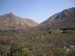
The trail heads due north up the steep canyon face above the campground and crosses the South Hawkins fire lookout access road twice. The second crossing is near the Big Cienega Spring after which it heads on a right oblique toward the ridge and the saddle, which is named Windy Gap. From this vantage point one faces into a seemingly perpetual wind that blows up from the broad canyon below. The benchmark here is posted at 7,588 feet (2,313 m).
The total hike is about 2 miles (3.2 km) and intersects the trails for Little Jimmy Trail Camp, Mount Islip, or other mountains east, South Hawkins, Baden-Powell, and the Vincent Gap Trail.

The Red Rock Canyon National Conservation Area in Clark County, Nevada, is an area managed by the Bureau of Land Management as part of its National Landscape Conservation System, and protected as a National Conservation Area. It is about 15 miles (24 km) west of Las Vegas, and is easily seen from the Las Vegas Strip. More than two million people visit the area each year.
East Fork Road, located in the San Gabriel Mountains above the city of Azusa, California, is a road that gives access from State Route 39 into East Fork and other small townships including Camp Williams, and Julius Klein Conservation Fire Camp 19, a minor offender prisoner housing complex where "LACO fire personnel provide training, which prepares inmates to safely conduct wild land firefighting operations."

The Angeles National Forest (ANF) of the U.S. Forest Service is located in the San Gabriel Mountains and Sierra Pelona Mountains, primarily within Los Angeles County in southern California. The ANF manages a majority of the San Gabriel Mountains National Monument.
Mission Trails Regional Park is a 5,800-acre (23 km2) open space preserve within the city of San Diego, California, established in 1974. It is the sixth-largest municipally owned park in the United States, and the largest in California.

Cajon Pass is a mountain pass between the San Bernardino Mountains and the San Gabriel Mountains in Southern California. It was created by the movements of the San Andreas Fault. Located in the Mojave Desert, the pass is an important link from the Greater San Bernardino Area to the Victor Valley, and northeast to Las Vegas.

The Silver Moccasin Trail is a 53-mile (85 km) trail located in the San Gabriel Mountains, northeast of Los Angeles. It begins at Chantry Flat Recreation Area above the city of Arcadia, California, traversing upward and down through several canyons and along the high ridges of the Angeles National Forest. This trail connects Mt. Baden-Powell, Mount Burnham, Throop Peak and Mount Hawkins. It comes to its highest point of 9,399 feet (2,865 m) at Mount Baden-Powell after which point it descends to its terminus at Vincent Gap on the Angeles Crest Highway near Wrightwood.
South Mount Hawkins is located in the San Gabriel Mountains, and contained within the Angeles National Forest. The mountain was named after Nellie Hawkins, a popular waitress of the Squirrel Inn located on the North Fork of the San Gabriel River.
Although the Squirrel Inn is long gone, Nellie has her name on Mount Hawkins and South Mount Hawkins. There are two ridge bumps between the two named summits and they are unofficially known as "Middle Hawkins" and "Sadie Hawkins".

The Angeles Forest Highway is a road over the San Gabriel Mountains in Los Angeles County, California. It connects the Los Angeles Basin with the Antelope Valley and western Mojave Desert. The highway is also known as County Road N-3 or FH-59 or the Palmdale cutoff; the route numbers are unsigned, but noted on many maps. It is about 25 miles (40 km) long.

The Bridge to Nowhere is an arch bridge that was built in 1936 north of Azusa, California in the San Gabriel Mountains. It spans the East Fork of the San Gabriel River and was meant to be part of a road connecting the San Gabriel Valley with Wrightwood.

The San Gabriel Wilderness is a wilderness area created in 1968 of more than 36,118 acres (150 km2) within the Angeles National Forest and San Gabriel Mountains National Monument.

Chantry Flat is a designated "Recreation Area" within the Angeles National Forest, about three miles (5 km) into Big Santa Anita Canyon, and is closely associated with the towns of Arcadia and Sierra Madre, CA. The flat itself houses a large public picnic area, and is the starting point for several historic trails of the San Gabriel Mountains, including the 28.5-mile (45.9 km) Gabrielino Trail. The US Forest Service estimates the road to Chantry as the third busiest entry into the Angeles, next to CA State Highways 2 and 39.

Eaton Canyon is a major canyon beginning at the Eaton Saddle near Mount Markham and San Gabriel Peak in the San Gabriel Mountains in the Angeles National Forest, United States. Its drainage flows into the Rio Hondo river and then into the Los Angeles River. It is named after Judge Benjamin S. Eaton, who lived in the Fair Oaks Ranch House in 1865 not far from Eaton Creek.
The San Gabriel Mountains Trailbuilders (SGMTBs) is a 501(c)3 non-profit volunteer organization which performs hiking and nature trail building and maintenance within the Los Angeles Gateway District of the United States Forest Service which maintains the Angeles National Forest within the San Gabriel Mountains.

The Mount Adams Recreation Area is a 21,000-acre (8,500 ha) recreation area in the U.S. state of Washington managed by the Yakama Nation Wildlife Program. The area encompasses an ecologically complex and geologically active landscape. The region features the most rugged side of Mount Adams, including canyons and the Great Gap section of the Mount Adams circumnavigation route, a three-mile trail-less section over two great canyons and many difficult glacial creeks. At 12,276 feet (3,742 m), Mount Adams is one of the major Cascade mountains. The recreation area is on the east side of the mountain and is part of the Yakama Indian Reservation and includes the popular Bird Creek Meadows area.
Fish Canyon Falls is a tiered waterfall in Los Angeles County, California, located within the Angeles National Forest in the San Gabriel Mountains. The falls are located about 2 miles (3.2 km) northwest of Azusa on the Fish Canyon Creek.

The San Gabriel Complex Fire was a wildfire that burned in 2016 in the Angeles National Forest, Los Angeles County, California, United States. It was the combination of two separate wildfires: the Reservoir Fire and the Fish Fire, both of which ignited on June 20.
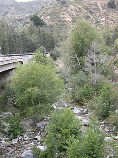
The North Fork San Gabriel River is a tributary, 4.5 miles (7.2 km) long, of the West Fork San Gabriel River in the Angeles National Forest of Los Angeles County, California. The river originates at the confluence of Soldier Creek and Coldbrook Creek in the San Gabriel Mountains below the village of Falling Springs and flows down a steep canyon in a southerly direction to join the West Fork near San Gabriel Reservoir. The North Fork Canyon provides the route for SR 39, one of the main access roads to the Angeles Forest.

