
Lassen Volcanic National Park is an American national park in northeastern California. The dominant feature of the park is Lassen Peak, the largest plug dome volcano in the world and the southernmost volcano in the Cascade Range. Lassen Volcanic National Park is one of the few areas in the world where all four types of volcano can be found—plug dome, shield, cinder cone, and stratovolcano.

Lassen Peak, commonly referred to as Mount Lassen, is a lava dome volcano and the southernmost active volcano in the Cascade Range of the Western United States. Located in the Shasta Cascade region of Northern California, it is part of the Cascade Volcanic Arc, which stretches from southwestern British Columbia to northern California. Lassen Peak reaches an elevation of 10,457 ft (3,187 m), standing above the northern Sacramento Valley. It supports many flora and fauna among its diverse habitats, which are subject to frequent snowfall and reach high elevations.

The Susan River is a northeastern California river of approximately 67 miles (108 km) length that drains from an arid plateau of volcanic highlands along the Great Basin Divide to intermittent Honey Lake. The river flows from eastern Lassen County from east of Lassen Volcanic National Park generally east past Susanville and emerging into a ranching valley to enter the north end of Honey Lake. Along with Fredonyer Pass, the Susan River is the northern boundary of the Sierra Nevada.

The California Trail was an emigrant trail of about 1,600 mi (2,600 km) across the western half of the North American continent from Missouri River towns to what is now the state of California. After it was established, the first half of the California Trail followed the same corridor of networked river valley trails as the Oregon Trail and the Mormon Trail, namely the valleys of the Platte, North Platte, and Sweetwater rivers to Wyoming. The trail has several splits and cutoffs for alternative routes around major landforms and to different destinations, with a combined length of over 5,000 mi (8,000 km).

The City of Rocks National Reserve, also known as the Silent City of Rocks, is a United States National Reserve and state park in south-central Idaho, approximately 2 miles (3.2 km) north of the border with Utah. It is widely known for its enormous granite rock formations and excellent rock climbing.
The Applegate Trail was an emigrant trail through the present-day U.S. states of Idaho, Nevada, California, and Oregon used in the mid-19th century by emigrants on the American frontier. It was originally intended as a less dangerous alternative to the Oregon Trail by which to reach the Oregon Territory. Much of the route was coterminous with the California Trail.
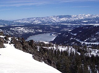
Donner Memorial State Park is a state park of California, US, preserving the site of the Donner Camp, where members of the ill-fated Donner Party were trapped by weather during the winter of 1846–1847. Caught without shelter or adequate supplies, members of the group resorted to cannibalism to survive. The Sierra Nevada site has been designated a National Historic Landmark. The state park contains the Emigrant Trail Museum and the Pioneer Monument dedicated to the travelers of the Emigrant Trail.
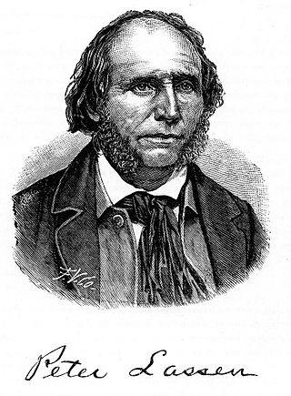
Peter Lassen, later known in Spanish as Don Pedro Lassen, was a Danish-born Californian ranchero and gold prospector. Born in Denmark, Lassen immigrated at age 30 to Massachusetts, before eventually finally moving to California. In California, Lassen became a Mexican citizen and received the vast Rancho Bosquejo from Governor Manuel Micheltorena. He is best known as the eponym of Lassen County, California, Lassen Peak, and Lassen Volcanic National Park.

Lassen National Forest is a United States national forest of 1,700 square miles (4,300 km2) in northeastern California. It is named after pioneer Peter Lassen, who mined, ranched and promoted the area to emigrant parties in the 1850s.

State Route 88 (SR 88), also known as the Carson Pass Highway, is a state highway in the U.S. state of California. It travels in an east–west direction from Stockton, in the San Joaquin Valley, to the Nevada state line, where it becomes Nevada State Route 88, eventually terminating at U.S. Route 395 (US 395). The highway is so named as it crests the Sierra Nevada at Carson Pass. The highway corridor predates the era of the automobile; the path over Carson pass was previously used for the California Trail and the Mormon Emigrant Trail. The mountainous portion of the route is included in the State Scenic Highway System.

Buildings, sites, districts, and objects in California listed on the National Register of Historic Places:

Isaac Newton Roop was an American politician, pioneer, and member of the Whig Party. In 1859, he was the first elected (provisional) governor of the newly-proposed Nevada Territory.

Lindsay Applegate was an American pioneer known for his participation in blazing the Applegate Trail, an alternative route of the Oregon Trail. The trail was blazed with his brothers Charles and Jesse in 1846, though Charles was not a member of the party that blazed the section of the Applegate Trail from the Willamette Valley to the Humboldt River. According to an original manuscript written by Lindsay Applegate in 1877, the members of the expedition were: Capt. Levi Scott, John Scott, Henry Boygus, Lindsay Applegate, Jesse Applegate, Benjamin Burch, John Owens, John Jones, Robert Smith, Samuel Goodhue, Moses "Black" Harris, David Goff, Benit Osburn, William Sportsman, and William Parker.
In the history of the American frontier, pioneers built overland trails throughout the 19th century, especially between 1829 and 1870, as an alternative to sea and railroad transport. These immigrants began to settle much of North America west of the Great Plains as part of the mass overland migrations of the mid-19th century. Settlers emigrating from the eastern United States did so with various motives, among them religious persecution and economic incentives, to move from their homes to destinations further west via routes such as the Oregon, California, and Mormon Trails. After the end of the Mexican–American War in 1849, vast new American conquests again encouraged mass immigration. Legislation like the Donation Land Claim Act and significant events like the California Gold Rush further encouraged settlers to travel overland to the west.
The Fernley & Lassen was a rail line of the Southern Pacific Railroad constructed in 1912–14 between Fernley, Nevada and Westwood, California, near Susanville, a distance of approximately 112 miles (180 km). The railroad was constructed to connect the Red River Lumber Company's facilities in Westwood with the Southern Pacific's main line running through Fernley. After the railroad's construction, it was heavily used by other nearby lumber companies; the Fruit Growers Supply Company maintained the longest-lived railroad connection with the Fernley & Lassen, with an active connection present between 1920 and 1953. Due to the Great Depression, which significantly lowered freight volume, and the completion of Western Pacific's competing branch to Westwood, however, the Fernley & Lassen's days were numbered. By 1934, passenger traffic service had been discontinued, with local rail freighting following it in 1956. In 1978, the Interstate Commerce Commission approved the Southern Pacific's petition for removal.
The Fandango Pass is a gap in the Warner Mountains of Modoc County, California, USA. Located in the Modoc National Forest, its elevation is 6,135 feet (1,870 m) above sea level. It is approximately 5 mi (8.0 km) southwest of Fort Bidwell.

Trego Hot Springs is located in the Black Rock Desert at the location of Trego, Nevada, a former station on the Western Pacific Railroad. The name "Trego" dates from the 1910s, just after the railroad was built. Previously, the springs had names like Hot Springs, Kyles Hot Springs (1864), Butte Spring, and Butte Hot Spring.

William H. Nobles was a U.S military officer, Treasury Agent, businessman, politician and trailblazer
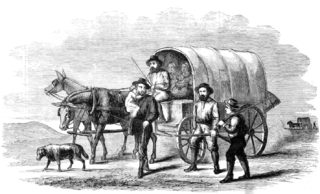
Lassen Emigrant Trail, also called the Lassen Cutoff is a historical road in Bieber, California and Westwood, California in Lassen County. Peter Lassen built the Lassen Emigrant Trail in 1848 as a cutoff of the California Trail. Lassen was the leader of a Wagon train from Missouri to California. The Wagon train included 12 covered wagons full of emigrants heading west, some part of the California Gold Rush. The Trail passed near the California historical marker. The Lassen Emigrant Trail was used from 1848 to 1953 by large groups of 49 miners. Indian wars started along the trail so emigrants started to use other trails. A California Historical Landmark marker No. 763, was placed near the trail in September 10, 1961. The marker was built by the California State Park Commission working with the Bieber and Lassen County Chambers of Commerce and Lassen County Historical Society at the Clara Bieber Memorial Park.


