
Lassen Volcanic National Park is an American national park in northeastern California. The dominant feature of the park is Lassen Peak, the largest plug dome volcano in the world and the southernmost volcano in the Cascade Range. Lassen Volcanic National Park is one of the few areas in the world where all four types of volcano can be found—plug dome, shield, cinder cone, and stratovolcano.

State Route 89 is a state highway in the U.S. state of California that travels in the north–south direction, serving as a major thoroughfare for many mountain communities in the Sierra Nevada and the Cascade Range. It starts from U.S. Route 395 near Topaz Lake, winding its way up to the 8,314-foot (2,534 m) Monitor Pass, down to the Carson River, and up again over the 7,740-foot (2,359 m) Luther Pass. From that point on, the route generally loses elevation on its way past Lake Tahoe, through Tahoe and Plumas National Forests until Lake Almanor. For roughly nine miles the route is then a part of State Route 36. The route then ascends to the 5,753-foot (1,754 m) Morgan Summit. After it enters Lassen Volcanic National Park it continues to gain elevation until it reaches its highest point in an unnamed pass in the middle of Lassen Peak and Bumpass Mountain. The road then descends and heads northwest, finally terminating at Interstate 5 at the foot of Mount Shasta at around 3,600 feet (1,100 m).

The Warner Valley Ranger Station, also known as the Warner Valley Patrol Cabin and Quarters 304, is located in the southern portion of Lassen Volcanic National Park, on the access road to the Drakesbad Guest Ranch. Built in 1926, it is unusual in its choice of construction method. While it resembles a log cabin, it was built using stacked milled 2x6 lumber to form the walls. It is the only such building known to have been built in this manner in the western regions of the National Park Service system. The interlocking boards extend past each other at the corners, forming a decorative detail.

Rim Village is the main area for tourist services in Crater Lake National Park in southern Oregon, United States. It is located on the southwest rim of the caldera overlooking Crater Lake. The National Park Service designed Rim Village to concentrate park services at a location that provided easy access to rim trails and view points. Because of the unique rustic architecture of the Rim Village structures and the surrounding park landscape, the area was listed as Rim Village Historic District on the National Register of Historic Places in 1997.
Munson Valley Historic District is the headquarters and main support area for Crater Lake National Park in southern Oregon. The National Park Service chose Munson Valley for the park headquarters because of its central location within the park. Because of the unique rustic architecture of the Munson Valley buildings and the surrounding park landscape, the area was listed as a historic district on the National Register of Historic Places (NRHP) in 1988. The district has eighteen contributing buildings, including the Crater Lake Superintendent's Residence which is a U.S. National Historic Landmark and separately listed on the NRHP. The district's NRHP listing was decreased in area in 1997.
Rim Drive is a scenic highway in Crater Lake National Park in southern Oregon, United States. It is a 33-mile (53 km) loop that follows the caldera rim around Crater Lake. Due to its unique engineering and the surrounding park landscape, the drive was listed as a historic district on the National Register of Historic Places in 2008.

Oregon Caves Historic District covers 6 acres (24,000 m2) in the main visitor area of Oregon Caves National Monument in southern Oregon. The district includes four primary buildings plus two other structures. Because of the unique rustic architecture of these National Park Service buildings and the surrounding park landscape, the area was listed on the National Register of Historic Places in 1992.

The Clackamas Lake Ranger Station Historic District is a Forest Service compound consisting of eleven historic buildings located in the Mount Hood National Forest in the Cascade Mountains of northern Oregon. It was originally built as a district ranger station for the Clackamas Lake Ranger District. It was later converted to a summer guard station. Today, the Forest Service rents the historic ranger's residence to recreational visitors. The Clackamas Lake Ranger Station is listed as a historic district on the National Register of Historic Places.

The Cabin Creek Ranger Residence and Dormitory, also known as the Cabin Creek Ranger Station, were built in 1934 and 1935 in Sequoia National Park by the Civilian Conservation Corps. The three-room wood-frame residence and the two-room dormitory are examples of the National Park Service Rustic style.

The Nobles Emigrant Trail, also known as the Fort Kearney, South Pass and Honey Lake Wagon Road, is a trail in California that was used by emigrant parties from the east as a shortened route to northern California. It was pioneered in 1851 by William Nobles, who discovered an easy shortcut between the Applegate Trail in Nevada and the Lassen Trail in California. The trail was extensively used until the 1870s, when it was superseded by railroads.

The Paulina Lake Guard Station is a Forest Service building located in the Newberry National Volcanic Monument in Central Oregon. The guard station was built by the Civilian Conservation Corps to house the seasonal assistant ranger responsible for patrolling the forest around Paulina Lake. Because of its rustic architecture, the guard station was listed on the National Register of Historic Places in 1986.

The Tiller Ranger Station is a United States Forest Service compound consisting of twenty-seven buildings in Oregon’s Umpqua National Forest. Over the years, it has been the administrative headquarters for five ranger districts. It is located in the small unincorporated community of Tiller, Oregon, United States. The historic structures were built in the rustic style by the Civilian Conservation Corps between 1935 and 1942. Today, the ranger station is the headquarters for the Tiller Ranger District, and is listed on the National Register of Historic Places.

The White River Entrance to Mount Rainier National Park is a complex of buildings built between 1929 and 1931 to accommodate visitors arriving on the Yakima Park Highway, in the northeastern portion of the park. Like most of the structures in Mount Rainier, the buildings are designed in the National Park Service Rustic style, using natural stone and log materials. The historic district includes the 1933 Men's Mess Hall and Dormitory, believed to be the only surviving camp structure built by the Civilian Conservation Corps in the park.

The Horseshoe Lake Ranger Station in Lassen Volcanic National Park, California is a backcountry ranger station that was built by Civilian Conservation Corps labor in 1934. The cabin typifies National Park Service standard designs for such structures in the prevailing National Park Service Rustic style then used by the Park Service. It is the only such example of a standard-plan backcountry ranger station in Lassen Volcanic National Park. There were originally two structures at the site, the residence, and a now-vanished barn.

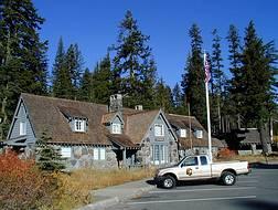
The Loomis Museum, also known as the Loomis Visitor Center, the Manzanita Lake Visitor Center and the Manzanita Lake Museum, was built by Benjamin Franklin Loomis in 1927 near Manzanita Lake, just outside Lassen Volcanic National Park in California, USA. Loomis was a local homesteader and photographer who documented the 1915 eruptions of Lassen Peak, and was instrumental in the 1916 establishment of the national park. In 1929 Loomis donated the museum and 40 acres (16 ha) of surrounding lands to the National Park Service, which since then has used the structure as an interpretational facility.

The Manzanita Lake Naturalist's Services Historic District encompasses the historic area devoted to visitor interpretation services at the northwest entrance of Lassen Volcanic National Park in northeastern California. The district's earliest structures were built by Benjamin and Estella Loomis, who were instrumental in the establishment of the park and among the park's first concessioners. The 1927 Loomis Museum and its seismograph hut were built by the Loomises and were donated, together with 40 acres (16 ha) of land to the National Park Service in 1929. The Loomis House, also known as the Loomis Art House and Manzanita Lake Ranger Station, was built about the same time as the museum and served as their residence, photography studio and shop until the 1950s under the name "B.F. Loomis Photo and Art Store".

The Summit Lake Ranger Station, also known as the Summit Lake Patrol Cabin, is one of the first three buildings constructed by the National Park Service in Lassen Volcanic National Park, California. Located near the center of the park on the main park road, the cabin was built in 1926. It is a log building measuring about 20 feet (6.1 m) by 30 feet (9.1 m) with an asymmetric gable roof that results in a long pitch to a low rear wall. The main portion of the station comprises a living area, kitchen, and two bedrooms. A former porch has been enclosed and houses a bathroom.
Architects of the National Park Service are the architects and landscape architects who were employed by the National Park Service (NPS) starting in 1918 to design buildings, structures, roads, trails and other features in the United States National Parks. Many of their works are listed on the National Register of Historic Places, and a number have also been designated as National Historic Landmarks.
Merel S. Sager was an American architect and landscape architect. He was employed by the National Park Service where he was a pioneer the form of "rustic architecture" that became known as "National Park Service rustic" architecture. He began working for the Park Service in 1928 and became its Chief Landscape Architect.
John Bernard Wosky was an American architect and landscape architect and park superintendent. He worked for the National Park Service from the 1920s through the 1950s and designed a number of works that have been listed on the National Register of Historic Places. He was assigned to Yosemite National Park from 1928 to 1952, initially as the parks's resident architect, and later as its assistant superintendent. He later served as the superintendent at Crater Lake National Park and Hawaii Volcanoes National Park.


