
Ansel Easton Adams was an American landscape photographer and environmentalist known for his black-and-white images of the American West. He helped found Group f/64, an association of photographers advocating "pure" photography which favored sharp focus and the use of the full tonal range of a photograph. He and Fred Archer developed a system of image-making called the Zone System, a method of achieving a desired final print through a technical understanding of how the tonal range of an image is the result of choices made in exposure, negative development, and printing.

The John Muir Trail (JMT) is a long-distance trail in the Sierra Nevada mountain range of California, passing through Yosemite, Kings Canyon and Sequoia National Parks. It is named after John Muir, a naturalist.

The Ansel Adams Wilderness is a wilderness area in the Sierra Nevada of California, United States. The wilderness spans 231,533 acres (93,698 ha); 33.9% of the territory lies in the Inyo National Forest, 65.8% is in the Sierra National Forest, and the remaining 0.3% covers nearly all of Devils Postpile National Monument. Yosemite National Park lies to the north and northwest, while the John Muir Wilderness lies to the south.

The John Muir Wilderness is a wilderness area that extends along the crest of the Sierra Nevada of California for 90 miles (140 km), in the Inyo and Sierra National Forests. Established in 1964 by the Wilderness Act and named for naturalist John Muir, it encompasses 652,793 acres (2,641.76 km2). The wilderness lies along the eastern escarpment of the Sierra from near Mammoth Lakes and Devils Postpile National Monument in the north, to Cottonwood Pass near Mount Whitney in the south. The wilderness area also spans the Sierra crest north of Kings Canyon National Park, and extends on the west side of the park down to the Monarch Wilderness.

Sierra National Forest is a U.S. national forest located on the western slope of central Sierra Nevada in Central California and bounded on the northwest by Yosemite National Park and the south by Kings Canyon National Park. The forest is known for its mountain scenery and beautiful lakes. Forest headquarters are located in Clovis, California. There are local ranger district offices in North Fork and Prather.
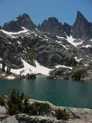
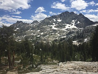
The Minarets are a series of jagged peaks located in the Ritter Range, a sub-range of the Sierra Nevada in the state of California. They are easily viewed from Minaret Summit, which is accessible by auto. Collectively, they form an arête, and are a prominent feature in the Ansel Adams Wilderness which was known as the Minaret Wilderness until it was renamed in honor of Ansel Adams in 1984.

Mount Ritter is the highest mountain in Madera County, California, in the Western United States, at an elevation of 13,149 feet (4,008 m). It is also the highest and most prominent peak of its namesake, the Ritter Range, a subrange of the Sierra Nevada in the Ansel Adams Wilderness of the Inyo and Sierra National Forests. Mount Ritter is the 15th highest mountain peak in California with at least 500 meters of topographic prominence.

Inyo National Forest is a United States National Forest covering parts of the eastern Sierra Nevada of California and the White Mountains of California and Nevada. The forest hosts several superlatives, including Mount Whitney, the highest point in the contiguous United States; Boundary Peak, the highest point in Nevada; and the Ancient Bristlecone Pine Forest, which protects the oldest living trees in the world. The forest, encompassing much of the Owens Valley, was established by Theodore Roosevelt as a way of sectioning off land to accommodate the Los Angeles Aqueduct project in 1907, making the Inyo National Forest one of the least wooded forests in the U.S. National Forest system.

Mount Williamson, at an elevation of 14,379 feet (4,383 m), is the second-highest mountain in both the Sierra Nevada range and the state of California, and the sixth-highest peak in the contiguous United States.
Banner Peak is the second tallest peak in the Ritter Range of California's Sierra Nevada. The mountain is 12,942 feet (3,945 m) tall, and there are several glaciers on its slopes. It lies within the boundaries of the Ansel Adams Wilderness; at the foot of the peak lie Garnet Lake, Lake Ediza, and the famous Thousand Island Lake. Banner Peak is near the town of Mammoth Lakes; from there, climbers can hike to the foot of the mountain where various routes reach the summit, the easiest of which is a class 2 from the west end of Thousand Island Lake and then the saddle between Banner Peak and the slightly taller Mount Ritter. Other nearby lakes include Lake Catherine and Shadow Lake.

The Ritter Range is a small mountain range within California's Sierra Nevada. Most of the mountain range lies within the Ansel Adams Wilderness.
The Kaiser Wilderness is a federally designated wilderness protected area located 70 miles (110 km) northeast of Fresno in the state of California, USA. It was added to the National Wilderness Preservation System by the United States Congress on October 19, 1976. The wilderness is 22,700 acres (92 km2) in size, is one of five wilderness areas within the Sierra National Forest and is managed by the US Forest Service.
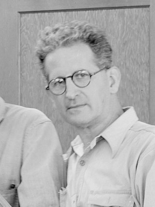
George Cedric Wright was an American violinist and a wilderness photographer of the High Sierra. He was Ansel Adams's mentor and best friend for decades, and accompanied Adams when three of his most famous photographs were taken. He was a longtime participant in the annual wilderness High Trips sponsored by the Sierra Club.
Parmelian Prints of the High Sierras is a portfolio of 18 silver gelatin photographic prints made by Ansel Adams in 1927. It was the first publication of a portfolio of his prints, produced not long after he decided to become a professional photographer, and has since been called "a landmark work in twentieth-century photography."

Carson Peak is a 10,908-foot-elevation (3,325-meter) mountain summit located in the Sierra Nevada mountain range, in Mono County of northern California, United States. It is situated in the Ansel Adams Wilderness, on land managed by Inyo National Forest. It is approximately 3.5 miles (5.6 km) southwest of the community of June Lake, 2.0 miles (3.2 km) south of Silver Lake, and 2.25 miles (3.62 km) northwest of San Joaquin Mountain, the nearest higher neighbor. The mountain is visible from various locations along the June Lake Loop, and from the nearby June Mountain ski area. The summit offers impressive views of Mount Ritter and Banner Peak. Topographic relief is significant as it rises 3,700 feet above the valley in 1.2 mile. The mountain consists of granite of Lee Vining Canyon. Carson Peak is considered an eastern Sierra classic by backcountry skiers drawn to routes called the "Devils Slide" and "Petes Dream".

Iron Mountain is an 11,149-foot-elevation (3,398 meter) summit located in the Sierra Nevada mountain range in Madera County of northern California, United States. It is situated in the Ansel Adams Wilderness, on the boundary shared by Inyo National Forest with Sierra National Forest. It is set at the south end of the Ritter Range, approximately 10 miles (16 km) west of the community of Mammoth Lakes. Devils Postpile National Monument is 4.5 miles to the east and the Minarets are three miles to the north. Precipitation runoff from the west side of this mountain drains to North Fork San Joaquin River, and from the east slope to the Middle Fork San Joaquin. Topographic relief is significant as the east aspect rises over 2,000 feet above Anona Lake in approximately one mile. There are climbing routes to the summit via the south slope and east face, and inclusion on the Sierra Peaks Section peakbagging list generates climbing interest.
Mount Julius Caesar is a 13,213-foot-elevation mountain summit located on the crest of the Sierra Nevada mountain range in northern California, United States. It is situated in the John Muir Wilderness on the boundary that Sierra National Forest shares with Inyo National Forest, and along the common border shared by Fresno County with Inyo County. It is one mile southwest of line parent Bear Creek Spire, and 22 miles (35 km) west of the community of Bishop. Italy Pass is one-half mile immediately south of the summit, and Granite Park lies to the southeast. Mount Julius Caesar ranks as the 106th-highest summit in California. Topographic relief is significant as the summit rises 2,000 feet above Lake Italy in 0.7 miles (1.1 km).
Volcanic Ridge is an 11,486-foot-elevation (3,501 meter) ridge located in the Sierra Nevada mountain range in Madera County of northern California, United States. It is situated in the Ansel Adams Wilderness on land managed by Inyo National Forest. It is set in the Ritter Range, 1.9 miles (3.1 km) southeast of Mount Ritter, and approximately 10 miles (16 km) west of the community of Mammoth Lakes. The Minarets are one mile to the west and Devils Postpile National Monument is five miles to the southeast. Topographic relief is significant as the west aspect rises over 1,700 feet above Iceberg Lake in approximately one-half mile.

Sawmill Point is a 9,429-foot-elevation (2,874 meter) mountain summit located in Inyo County, California. It is situated 2.6 miles east of the crest of the Sierra Nevada mountain range, in the John Muir Wilderness, on land managed by Inyo National Forest. It is also 10.5 miles (16.9 km) northwest of the community of Independence, and 2.6 miles (4.2 km) east of proximate parent Colosseum Mountain. Topographic relief is significant as the summit rises 4,770 feet above Owens Valley in two miles. The Sawmill Pass Trail traverses the east and south slopes of the peak, providing an approach option, and access to the John Muir Trail.


