
Yosemite National Park is an American national park in the state of California, surrounded on the southeast by Sierra National Forest and on the northwest by Stanislaus National Forest. The park is managed by the National Park Service and covers an area of 759,620 acres in four counties – centered in Tuolumne and Mariposa, extending north and east to Mono and south to Madera County. Designated a World Heritage Site in 1984, Yosemite is internationally recognized for its cliffs, waterfalls, clear streams, giant sequoia groves, lakes, mountains, meadows, glaciers, and biological diversity. Almost 95 percent of the park is designated wilderness. Yosemite is one of the largest and least fragmented habitat blocks in the Sierra Nevada, and the park supports a diversity of plants and animals.
Sequoiadendron giganteum, also known as the giant sequoia, is the sole living species in the genus Sequoiadendron, and one of three species of coniferous trees known as redwoods, classified in the family Cupressaceae in the subfamily Sequoioideae, together with Sequoia sempervirens and Metasequoia glyptostroboides. Giant sequoia specimens are the most massive trees on Earth. The common use of the name sequoia usually refers to Sequoiadendron giganteum, which occurs naturally only in groves on the western slopes of the Sierra Nevada mountain range of California.

The John Muir Trail (JMT) is a long-distance trail in the Sierra Nevada mountain range of California, passing through Yosemite, Kings Canyon and Sequoia National Parks. From the northern terminus at Happy Isles in Yosemite Valley and the southern terminus located on the summit of Mount Whitney, the trail's length is 213.7 miles (343.9 km), with a total elevation gain of approximately 47,000 feet (14,000 m). For almost all of its length, the trail is in the High Sierra backcountry and wilderness areas. For about 160 miles (260 km), the trail follows the same footpath as the longer Pacific Crest Trail. It is named after John Muir, a naturalist.

Kings Canyon National Park is an American national park in the southern Sierra Nevada, in Fresno and Tulare Counties, California. Originally established in 1890 as General Grant National Park, the park was greatly expanded and renamed on March 4, 1940. The park's namesake, Kings Canyon, is a rugged glacier-carved valley more than a mile (1,600 m) deep. Other natural features include multiple 14,000-foot (4,300 m) peaks, high mountain meadows, swift-flowing rivers, and some of the world's largest stands of giant sequoia trees. Kings Canyon is north of and contiguous with Sequoia National Park, and both parks are jointly administered by the National Park Service as the Sequoia and Kings Canyon National Parks.

Sequoia National Park is an American national park in the southern Sierra Nevada east of Visalia, California. The park was established on September 25, 1890, and today protects 404,064 acres of forested mountainous terrain. Encompassing a vertical relief of nearly 13,000 feet (4,000 m), the park contains the highest point in the contiguous United States, Mount Whitney, at 14,505 feet (4,421 m) above sea level. The park is south of, and contiguous with, Kings Canyon National Park; both parks are administered by the National Park Service together as the Sequoia and Kings Canyon National Parks. UNESCO designated the areas as Sequoia-Kings Canyon Biosphere Reserve in 1976.

Calaveras Big Trees State Park is a state park of California, United States, preserving two groves of giant sequoia trees. It is located 4 miles (6.4 km) northeast of Arnold, California in the middle elevations of the Sierra Nevada. It has been a major tourist attraction since 1852, when the existence of the trees was first widely reported, and is considered the longest continuously operated tourist facility in California.

General Grant Grove, a section of the greater Kings Canyon National Park, was established by the U.S. Congress in 1890 and is located in Fresno County, California. The primary attraction of General Grant Grove is the giant sequoia trees that populate the grove. General Grant Grove's most well-known tree is called General Grant, which is 267 ft (81 m) tall and the third-largest known tree in the world. The General Grant tree is over 1,500 years old and is known as the United States' national Christmas tree. General Grant Grove consists of 154 acres (0.62 km2) and is geographically isolated from the rest of Kings Canyon National Park.

Nelder Grove, located in the western Sierra Nevada within the Sierra National Forest in Madera County, California, is a Giant sequoia grove that was formerly known as Fresno Grove. The grove is a 1,540-acre (6.2 km2) tract containing 54 mature Giant Sequoia trees, the largest concentration of giant sequoias in the Sierra National Forest. The grove also contains several historical points of interest, including pioneer cabins and giant sequoia stumps left by 19th century loggers.
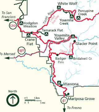
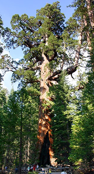
Mariposa Grove is a sequoia grove located near Wawona, California, United States, in the southernmost part of Yosemite National Park. It is the largest grove of giant sequoias in the park, with several hundred mature examples of the tree. Two of its trees are among the 30 largest giant sequoias in the world. The grove closed on July 6, 2015, for a restoration project and reopened on June 15, 2018.

Sequoia National Forest is located in the southern Sierra Nevada mountains of California. The U.S. National Forest is named for the majestic Giant Sequoia trees which populate 38 distinct groves within the boundaries of the forest.

Tahoe National Forest is a United States National Forest located in California, northwest of Lake Tahoe. It includes the 8,587-foot (2,617 m) peak of Sierra Buttes, near Sierra City, which has views of Mount Lassen and Mount Shasta. It is located in parts of six counties: Sierra, Placer, Nevada, Yuba, Plumas and El Dorado. The forest has a total area of 871,495 acres. Its headquarters is in Nevada City, California. There are local ranger district offices in Camptonville, Foresthill, Sierraville and Truckee.

Mineral King is a subalpine glacial valley located in the southern part of Sequoia National Park, in the U.S. state of California. The valley lies at the headwaters of the East Fork of the Kaweah River, which rises at the eastern part of the valley and flows northwest. Accessed by a long and narrow winding road, the valley is mostly popular with backpackers and hikers.

The High Sierra Trail (HST) is a hiking trail in Sequoia National Park, California. The trail crosses the Sierra Nevada from west to east. According to the Yosemite Decimal System, the HST is a Class 1/Class 2 trail, which means simple scrambling, with the possibility of occasional use of the hands for balance.

The Kaweah River is a river draining the southern Sierra Nevada in Tulare County, California in the United States. Fed primarily by high elevation snowmelt along the Great Western Divide, the Kaweah begins as four forks in Sequoia National Park, where the watershed is noted for its alpine scenery and its dense concentrations of giant sequoias, the largest trees on Earth. It then flows in a southwest direction to Lake Kaweah – the only major reservoir on the river – and into the San Joaquin Valley, where it diverges into multiple channels across an alluvial plain around Visalia. With its Middle Fork headwaters starting at almost 13,000 feet (4,000 m) above sea level, the river has a vertical drop of nearly two and a half miles (4.0 km) on its short run to the San Joaquin Valley, making it one of the steepest river drainages in the United States. Although the main stem of the Kaweah is only 33.6 miles (54.1 km) long, its total length including headwaters and lower branches is nearly 100 miles (160 km).
Redwood Mountain Grove is the largest grove of giant sequoia trees on earth. It is located in Kings Canyon National Park and Giant Sequoia National Monument on the western slope of California's Sierra Nevada. The grove contains the world's tallest giant sequoia. The Hart Tree and Roosevelt Tree grow in the grove and are two of the 25 largest trees by volume in the world. The largest tree is the General Sherman Tree in the Giant Forest grove to the southeast.

The Giant Forest, famed for its giant sequoia trees, is within the United States' Sequoia National Park. This montane forest, situated at over 6,000 ft (1,800 m) above mean sea level in the western Sierra Nevada of California, covers an area of 1,880 acres (7.6 km2). The Giant Forest is the most accessible of all giant sequoia groves, as it has over 40 mi (64 km) of hiking trails.

Converse Basin Grove is a grove of giant sequoia trees in the Giant Sequoia National Monument in the Sierra Nevada, in Fresno County, California, 5 miles (8 km) north of General Grant Grove, just outside Kings Canyon National Park. Once home to the second-largest population of giant sequoias in the world, covering 4,600 acres (19 km2) acres, the grove was extensively logged by the Sanger Lumber Company at the turn of the 20th century. The clearcutting of 8,000 giant sequoias, many of which were over 2,000 years old, resulted in the destruction of the old-growth forest ecosystem.
The Monarch Wilderness is a federally designated wilderness area located 70 miles east of Fresno, California, in the Sierra Nevada mountain range. It encompasses 44,896 acres (181.69 km2) within both the Sequoia National Forest and the Sierra National Forest and is managed by the United States Forest Service. Elevations range from 950 feet (290 m) to 11,081 ft (3,377 m).

The North Fork Kaweah River is a 21.4-mile (34.4 km)-long tributary of the Kaweah River in Tulare County, California. The river starts at the confluence of Dorst Creek and Stony Creek, near Dorst Creek Campground in Sequoia National Park. It flows west and is joined by Redwood Creek, which drains Redwood Mountain Grove, the largest grove of giant sequoias on earth. The river then turns south, flowing through a remote canyon, forming the western boundary of the park as far as Yucca Creek, which flows from Crystal Cave in Sequoia National Park. It continues south and passes the Three Rivers Airport before emptying into the Kaweah River at Three Rivers.


