
The Sierra Nevada is a mountain range in the Western United States, between the Central Valley of California and the Great Basin. The vast majority of the range lies in the state of California, although the Carson Range spur lies primarily in Nevada. The Sierra Nevada is part of the American Cordillera, an almost continuous chain of mountain ranges that forms the western "backbone" of the Americas.

Kings Canyon National Park is a national park of the United States in the southern Sierra Nevada, in Fresno and Tulare Counties, California. Originally established in 1890 as General Grant National Park, the park was greatly expanded and renamed on March 4, 1940. The park's namesake, Kings Canyon, is a rugged glacier-carved valley more than a mile (1,600 m) deep. Other natural features include multiple 14,000-foot (4,300 m) peaks, high mountain meadows, swift-flowing rivers, and some of the world's largest stands of giant sequoia trees. Kings Canyon is north of and contiguous with Sequoia National Park, and both parks are jointly administered by the National Park Service as the Sequoia and Kings Canyon National Parks.

Sequoia National Park is a national park of the United States in the southern Sierra Nevada east of Visalia, California. The park was established on September 25, 1890, and today protects 404,064 acres of forested mountainous terrain. Encompassing a vertical relief of nearly 13,000 feet (4,000 m), the park contains the highest point in the contiguous United States, Mount Whitney, at 14,505 feet (4,421 m) above sea level. The park is south of, and contiguous with, Kings Canyon National Park; both parks are administered by the National Park Service together as Sequoia and Kings Canyon National Parks. UNESCO designated the areas as Sequoia-Kings Canyon Biosphere Reserve in 1976.

The Kings River, is a 132.9-mile (213.9 km) river draining the Sierra Nevada mountain range in central California in the United States. Its headwaters originate along the Sierra Crest in and around Kings Canyon National Park and form the eponymous Kings Canyon, one of the deepest river gorges in North America. The river is impounded in Pine Flat Lake before flowing into the San Joaquin Valley southeast of Fresno. With its upper and middle course in Fresno County, the Kings River diverges into multiple branches in Kings County, with some water flowing south to the old Tulare Lake bed and the rest flowing north to the San Joaquin River. However, most of the water is consumed for irrigation well upstream of either point.

The Clavey River is a tributary of the Tuolumne River in the Sierra Nevada, located in the Stanislaus National Forest and Tuolumne County, California. The river is 31.3 miles (50.4 km) long, and is one of the few undammed rivers on the western slope of the Sierra. Via the Tuolumne River, the Clavey is part of the San Joaquin River watershed.

The Kaweah River is a river draining the southern Sierra Nevada in Tulare County, California in the United States. Fed primarily by high elevation snowmelt along the Great Western Divide, the Kaweah begins as four forks in Sequoia National Park, where the watershed is noted for its alpine scenery and its dense concentrations of giant sequoias, the largest trees on Earth. It then flows in a southwest direction to Lake Kaweah – the only major reservoir on the river – and into the San Joaquin Valley, where it diverges into multiple channels across an alluvial plain around Visalia. With its Middle Fork headwaters starting at almost 13,000 feet (4,000 m) above sea level, the river has a vertical drop of nearly two and a half miles (4.0 km) on its short run to the San Joaquin Valley, making it one of the steepest river drainages in the United States. Although the main stem of the Kaweah is only 33.6 miles (54.1 km) long, its total length including headwaters and lower branches is nearly 100 miles (160 km).

The Giant Forest, famed for its giant sequoia trees, is within the United States' Sequoia National Park. This montane forest, situated at over 6,000 ft (1,800 m) above mean sea level in the western Sierra Nevada of California, covers an area of 1,880 acres (7.6 km2). The Giant Forest is the most accessible of all giant sequoia groves, as it has over 40 mi (64 km) of hiking trails.

Freel Peak is a mountain located in the Carson Range, a spur of the Sierra Nevada, near Lake Tahoe in California.

The Tinajas Altas Mountains are an extremely arid northwest–southeast trending mountain range in southern Yuma County, Arizona, approximately 35 mi southeast of Yuma, Arizona. The southern end of the range extends approximately one mile into the northwestern Mexican state of Sonora on the northern perimeter of the Gran Desierto de Altar. The range is about 22 mi in length and about 4 mi wide at its widest point. The highpoint of the range is unnamed and is 2,766 feet above sea level and is located at 32°16'26"N, 114°02'48"W. Aside from the portion of the range in Mexico, the entirety of the range lies within the Barry M. Goldwater Air Force Range. They lie at the heart of the traditional homeland of the Hia C-eḍ O'odham people.
The Monarch Wilderness is a federally designated wilderness area located 70 miles east of Fresno, California, in the Sierra Nevada mountain range. It encompasses 44,896 acres (181.69 km2) within both the Sequoia National Forest and the Sierra National Forest and is managed by the United States Forest Service. Elevations range from 950 feet (290 m) to 11,081 ft (3,377 m).
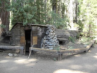
Tharp's Log is a hollowed giant sequoia log at Log Meadow in the Giant Forest grove of Sequoia National Park that was used as a shelter by early pioneers. The log is named after Hale D. Tharp, who was described as the first Non-Native American to enter the Giant Forest.
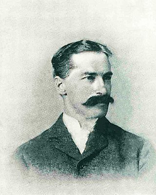
Richard Urquhart Goode was an American geographer and topographer with the United States Geological Survey (USGS) Northern Transcontinental Railroad Survey, and the Panama Canal Company. Goode was in charge of the Western Division of the USGS. which included all lands west of the Mississippi River, and worked on the boundary between the United States and Canada.
Thunder Mountain is located in the northern part of the Great Western Divide, a sub-range of the Sierra Nevada in California. The summit marks a point on the boundary between Sequoia and Kings Canyon national parks and is 0.6 miles (1 km) north of Table Mountain and south 2.8 miles (4.5 km) Mount Brewer. Thunder pass, on the mountains east side, has an elevation of 12,720+ feet. This pass marks the western end of the Kings-Kern Divide.
The Sierra Madre Range is a mountain range in the western United States, located in south-central Wyoming and north-central Colorado. Geologically, it may be considered an extension of the Park Range of Colorado. South of the Great Divide Basin, the US Continental Divide runs along the Sierre Madre high points. Its western basins drain into the Colorado River and its eastern into the North Platte River. Buck Mountain, elevation 11,396 feet, is the highest peak in the range and lies within Colorado. Bridger Peak, elevation 11,004 feet, is the range's highest elevation in Wyoming.

The South Fork Kings River is a 44.1-mile (71.0 km) tributary of the Kings River in the Sierra Nevada of Fresno County, California. The river forms part of Kings Canyon, the namesake of Kings Canyon National Park and one of the deepest canyons in North America with a maximum relief of 8,200 feet (2,500 m) from rim to river.

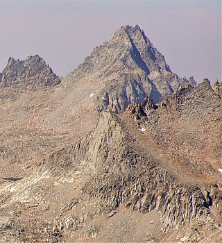
Mount McAdie is a summit on the crest of the Sierra Nevada, and is located 2.1 miles (3.4 km) south of Mount Whitney. It has three summits, with the north peak being the highest. The summit ridge marks the boundary between Sequoia National Park and the John Muir Wilderness. It is also on the boundary between Inyo and Tulare counties. Lone Pine, 12.4 miles (20.0 km) to the northeast, is in the Owens Valley on U.S. 395.
The Little Kern River is a 24.4-mile-long (39.3 km) major tributary of the upper Kern River in the Sequoia National Forest, in the southern Sierra Nevada, California. It is one of three streams, along with Volcano Creek and Golden Trout Creek, that harbor beautiful golden trout.

Dogwood is an unincorporated community in northwestern Douglas County, Missouri, United States. It is located on Missouri Route 14, approximately 15.5 miles (24.9 km) northwest of Ava and 8.5 miles (13.7 km) southwest of Seymour. The old store building sits at the intersection of Route 14 with route BB and the Dogwood cemetery is 1,300 feet (400 m) to the west at the intersection of routes 14 and Z.

François Émile Matthes was a geologist and an expert in topographic mapping, glaciers, and climate change. He mapped remote areas of the American West for the United States Geological Survey (USGS). His maps coincided with the development of those areas into national parks. He is one of the founders of the Association of American Geographers and served as its president. Matthes resolved a dispute about formation of the Yosemite Valley and his findings on glaciers introduced the terms nivation and Little Ice Age.

Pilot Knob is a 12,245-foot-elevation (3,732 meter) mountain summit located in Fresno County in the Sierra Nevada mountain range in northern California, United States. It is situated at the intersection of Piute Canyon and French Canyon, in the John Muir Wilderness, on land managed by Sierra National Forest. It is set 2.5 miles (4.0 km) south of Merriam Peak and three miles north of the Matthes Glaciers. Pilot Knob is the 360th-highest peak in California, and topographic relief is significant as the west aspect rises 2,800 feet above Hutchinson Meadow in approximately one mile. This mountain was likely named by the USGS during the 1907–09 survey for the Mt. Goddard Quadrangle, and the toponym has been officially adopted by the U.S. Board on Geographic Names.


