
The John Muir Trail (JMT) is a long-distance trail in the Sierra Nevada mountain range of California, passing through Yosemite, Kings Canyon and Sequoia National Parks. From the northern terminus at Happy Isles in Yosemite Valley and the southern terminus located on the summit of Mount Whitney, the trail's length is 213.7 miles (343.9 km), with a total elevation gain of approximately 47,000 feet (14,000 m). For almost all of its length, the trail is in the High Sierra backcountry and wilderness areas. For about 160 miles (260 km), the trail follows the same footpath as the longer Pacific Crest Trail. It is named after John Muir, a naturalist.

Tuolumne Meadows is a gentle, dome-studded, sub-alpine meadow area along the Tuolumne River in the eastern section of Yosemite National Park in the United States. Its approximate location is 37°52.5′N119°21′W. Its approximate elevation is 8,619 feet (2,627 m). The term Tuolumne Meadows is also often used to describe a large portion of the Yosemite high country around the meadows, especially in context of rock climbing.

The Cathedral Range is a mountain range immediately to the south of Tuolumne Meadows in Yosemite National Park. The range is an offshoot of the Sierra Nevada. The range is named after Cathedral Peak, which resembles a cathedral spire.

Hetch Hetchy is a valley, a reservoir, and a water system in California in the United States. The glacial Hetch Hetchy Valley lies in the northwestern part of Yosemite National Park and is drained by the Tuolumne River. For thousands of years before the arrival of settlers from the United States in the 1850s, the valley was inhabited by Native Americans who practiced subsistence hunting-gathering. During the late 19th century, the valley was renowned for its natural beauty – often compared to that of Yosemite Valley – but also targeted for the development of water supply for irrigation and municipal interests. The controversy over damming Hetch Hetchy became mired in the political issues of the day. The law authorizing the dam passed Congress on December 7, 1913.

The Tuolumne River flows for 149 miles (240 km) through Central California, from the high Sierra Nevada to join the San Joaquin River in the Central Valley. Originating at over 8,000 feet (2,400 m) above sea level in Yosemite National Park, the Tuolumne drains a rugged watershed of 1,958 square miles (5,070 km2), carving a series of canyons through the western slope of the Sierra. While the upper Tuolumne is a fast-flowing mountain stream, the lower river crosses a broad, fertile and extensively cultivated alluvial plain. Like most other central California rivers, the Tuolumne is dammed multiple times for irrigation and the generation of hydroelectricity.

Lembert Dome is a granite dome rock formation in Yosemite National Park in the US state of California. The dome soars 800 feet (240 m) above Tuolumne Meadows and the Tuolumne River and can be hiked starting at the Tioga Road in the heart of Tuolumne Meadows, 8 miles (13 km) west of the Tioga Pass Entrance to Yosemite National Park. The landform is an example of a rôche moutonnée with clear lee and stoss slopes.

Waterwheel Falls is a waterfall in the Sierra Nevada of California, located in Yosemite National Park. It is the largest of the many waterfalls of the Tuolumne River. Its upper part contains a series of small ledges, each of which creates a small plume as the water is deflected away from the rock face. A regular phenomenon appears at the first and largest of these ledges during the high-water season of early summer. Strong gusts of wind can lift part of the spray and blow it back upward, causing it to reenter the falls above the ledge. This cyclic "waterwheel" gives the falls their name.

The Grand Canyon of the Tuolumne is the notable canyon section of the river valley of the Tuolumne River, located within Yosemite National Park, in Tuolumne County and the Sierra Nevada, California.

Mount Lyell is the highest point in Yosemite National Park, at 13,114 feet (3,997 m). It is located at the southeast end of the Cathedral Range, 1+1⁄4 miles northwest of Rodgers Peak. The peak as well as nearby Lyell Canyon is named after Charles Lyell, a well-known 19th century geologist. The peak had one of the last remaining glaciers in Yosemite, Lyell Glacier. The Lyell Glacier is currently considered to be a permanent ice field, not a living glacier. Mount Lyell divides the Tuolumne River watershed to the north, the Merced to the west, and the Rush Creek drainage in the Mono Lake Basin to the southeast.
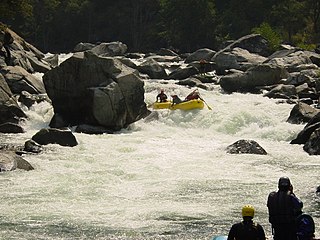
Cherry Creek is a large, swift-flowing stream in the Sierra Nevada mountain range, and is the largest tributary of the Tuolumne River. The creek is 40 miles (64 km) long measured to its farthest headwaters; the main stem itself is 26 miles (42 km) long, draining a watershed of 234 square miles (610 km2) in the Stanislaus National Forest. Part of the drainage also extends into the northwest corner of Yosemite National Park.
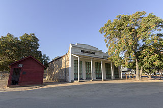
La Grange is a small unincorporated community in rural Stanislaus County, California. Its altitude is 249 feet (76 m). As of 2008 it has a population of 345. It is located at 37°39′49″N120°27′49″W along the Tuolumne River, and is near the La Grange Dam and the New Don Pedro Dam.
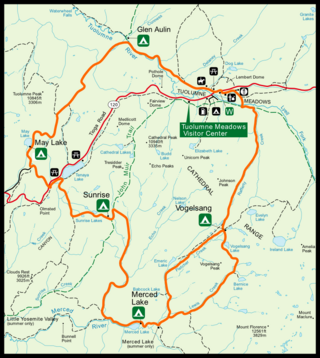
The High Sierra Camps are nine rustic lodging facilities located in two national parks and a national monument in California's Sierra Nevada mountain range. Open most years from June or July to September, they are staffed camps with tent cabins and food service facilities. The backcountry camps receive their supplies by pack mules.

Matthes Crest is an approximately mile-long fin of rock with two summits separated by a deep notch. It is a part of the Cathedral Range, which is a mountain range in the south-central portion of Yosemite National Park. The range is part of the Sierra Nevada.

Rancheria Creek is a 22-mile (35 km) long stream in northern Yosemite National Park mostly in Tuolumne County, California and is a tributary of the Tuolumne River. Draining a large area of the Sierra Nevada, it is the largest tributary of the Tuolumne within Yosemite National Park. The stream is labeled as Kerrick Creek on some early maps.
Kuna Crest Granodiorite, is found, in Yosemite National Park, United States. The granodiorite forms part of the Tuolumne Intrusive Suite, one of the four major intrusive suites within the Sierra Nevada. Of the Tuolumne Intrusive Suite, it is the oldest and darkest rock.

Hiking, rock climbing, and mountain climbing around Tuolumne Meadows in Yosemite National Park has many options.
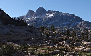
Finger Peaks is a granitic mountain summit with an elevation of 11,498 feet (3,505 m) located in the Sierra Nevada mountain range, in northern California, United States. The three peaks are situated in Yosemite National Park and Tuolumne County. The landform is set immediately west of Burro Pass, 1.5 mile south of Eocene Peak, and 1.4 mile southwest of Matterhorn Peak. Topographic relief is significant as the summit rises 1,700 feet (518 meters) above Piute Creek in one-half mile. The first ascent of the summit was made July 19, 1931, by Jules Eichorn, Glen Dawson, and Walter Brem. This landform's toponym has been in publications since at least 1925, and was officially adopted by the U.S. Board on Geographic Names in 1932.
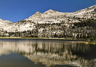
Rafferty Peak is an 11,110-foot-elevation mountain summit located in Yosemite National Park, in California, United States. It is situated on the common border shared by Mariposa and Tuolumne Counties. It is set south of Tuolumne Meadows in the Cathedral Range which is a sub-range of the Sierra Nevada mountain range. The mountain rises one mile (1.6 km) northwest of Tuolumne Pass, 1.4 mile south of Johnson Peak, and 2.5 miles east of Matthes Crest. Tuolumne Pass is the low point of the saddle between Rafferty Peak and Fletcher Peak. Topographic relief is significant as the summit rises 1,500 feet (457 meters) above Nelson Lake in one mile.


