
Tuolumne County, officially the County of Tuolumne, is a county in the U.S. state of California. As of the 2010 census, the population was 54,539. The county seat and only incorporated city is Sonora.

Sonora is the county seat of Tuolumne County, California. Founded during the California Gold Rush by Mexican miners from Sonora, the city population was 4,610 during the 2010 Census, an increase of 380 from the 4,230 counted during the 2000 Census. Sonora is the only incorporated community in Tuolumne County.

The Tuolumne River flows for 149 miles (240 km) through Central California, from the high Sierra Nevada to join the San Joaquin River in the Central Valley. Originating at over 8,000 feet (2,400 m) above sea level in Yosemite National Park, the Tuolumne drains a rugged watershed of 1,958 square miles (5,070 km2), carving a series of canyons through the western slope of the Sierra. While the upper Tuolumne is a fast-flowing mountain stream, the lower river crosses a broad, fertile and extensively cultivated alluvial plain. Like most other central California rivers, the Tuolumne is dammed multiple times for irrigation and the generation of hydroelectricity.

State Route 49 is a north–south state highway in the U.S. state of California that passes through many historic mining communities of the 1849 California gold rush. Highway 49 is numbered after the "49ers", the waves of immigrants who swept into the area looking for gold, and it is known as the Golden Chain Highway. This roadway begins at Oakhurst, Madera County, in the Sierra Nevada, where it diverges from State Route 41. It continues in a generally northwest direction, weaving through the communities of Goldside and Ahwahnee, before crossing into Mariposa County. State Route 49 then continues northward through the counties of Tuolumne, Calaveras, Amador, El Dorado, Placer, Nevada, Yuba, Sierra, and Plumas, where it reaches its northern terminus at State Route 70, in Vinton.

Central California is generally thought of as the middle third of the state, north of Southern California, which includes Los Angeles, and south of Northern California, which includes San Francisco. It includes the northern portion of the San Joaquin Valley, part of the Central Coast, the central hills of the California Coast Ranges and the foothills and mountain areas of the central Sierra Nevada.
The Tuolumne Band of Me-Wuk Indians is a federally recognized tribe of Miwok people in Tuolumne County, California. The Tuolumne Band are central Sierra Miwok people. Annually, in September, the tribe holds an acorn festival and intertribal gathering.

Knights Ferry is an unincorporated historic community in Stanislaus County, California, United States. Nestled in the foothills of the Sierra Nevada, it is about 40 miles (64 km) east of Modesto on the Stanislaus River. The Willms Ranch, a California Historical Landmark near the town, was one of many filming locations for the television series Bonanza and Little House on the Prairie.
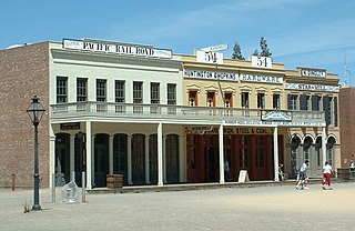
The Big Four Building is a historic 19th-century building in Downtown Sacramento, California. It is now located within Old Sacramento State Historic Park and the Old Sacramento National Historic District.

St. James Episcopal Church, also known as the Red Church, is an historic Episcopal church building, formerly Anglican, located at 42 Snell Street, in Sonora, California. Built in 1859 in the Carpenter Gothic style, its board and batten exterior walls are of California redwood and are painted red. It was consecrated in 1870 by the Rt. Rev. William Ingraham Kip, first bishop of the Episcopal Diocese of California. Reportedly the seventh Episcopal parish as well as the oldest Episcopal church building in California, it has been designated California Historical Landmark No. 139.

This is a list of the National Register of Historic Places listings in Tuolumne County, California.

The Tuolumne Meadows Ranger Station and Comfort Stations are examples of National Park Service Rustic design in Yosemite National Park. They are within the Tuolumne Meadows Historic District at Tuolumne Meadows. The ranger station was built in 1924 using peeled log construction. The ranger station doubled as the park entrance station for the Tioga Road. Its function was partly superseded by a newer structure in 1936, using larger quantities of stonework.
This is a list of the National Register of Historic Places listings in Yosemite National Park.

The Donnell Fire was a wildfire that started on August 1, 2018 due to an unattended campfire, near Donnell Reservoir, burning around California State Route 108 in Tuolumne County, California and in the Stanislaus National Forest. It spread rapidly, and the Forest Service closed a California state highway, many forest service roads, campgrounds, wilderness areas, access to privately-owned inholdings, and the Pacific Crest Trail. The fire burned 36,450 acres (147.5 km2), and destroyed 54 major structures and 81 minor structures, before the fire burned out on October 1. There were nine injuries caused by the fire, but no deaths.
The Baker Highway Maintenance Station, in Tuolumne County, California near Strawberry, California, was built in 1931. It was listed on the National Register of Historic Places in 2004. The listing included 11 contributing buildings and a contributing object on 5.8 acres (2.3 ha).

The Gamble Building and Miner's Bean Kettle in Big Oak Flat, California was listed on the National Register of Historic Places in 1991.
The Superior Court of California, County of Tuolumne, also known as the Tuolumne County Superior Court, is the branch of the California superior court with jurisdiction over Tuolumne County.


