| Date | Country and location | Mw | Depth (km) | MMI | Notes | Casualties |
|---|
| Dead | Injured |
|---|
| 3 [43] |  Chile, Biobío Region, 25 km WNW of Talcahuano Chile, Biobío Region, 25 km WNW of Talcahuano | 6.1 | 20.0 | VII | Aftershock of the 8.8 event on February 27 | - | - |
| 4 [44] |  Taiwan, Tainan, 41 km SE of Yujing District Taiwan, Tainan, 41 km SE of Yujing District | 6.3 | 21.0 | VI | The 2010 Kaohsiung earthquake caused minor damage and over 90 injuries. [45] | - | 90+ |
| 4 [46] | Chile, Valparaíso Region, 50 km WSW of Valparaíso | 6.0 | 24.2 | V | Aftershock of the 8.8 earthquake on February 27 | - | - |
| 4 [47] |  Vanuatu, Torba Province, 48 km NW of Sola Vanuatu, Torba Province, 48 km NW of Sola | 6.5 | 176.0 | IV | | - | - |
| 4 [48] | Chile, Antofagasta Region, 66 km ENE of Calama | 6.3 | 114.0 | IV | - | - | - |
| 5 [49] | Chile, Biobío Region, 14 km NW of Talcahuano | 6.1 | 29.9 | V | Aftershock of the 8.8 event on February 27 | - | - |
| 5 [50] | Chile, Biobío Region, 23 km WNW of Talcahuano | 6.6 | 18.0 | VII | Aftershock of the 8.8 event on February 27 | - | - |
| 5 [51] |  Indonesia, Bengkulu, 141 km W of Bengkulu Indonesia, Bengkulu, 141 km W of Bengkulu | 6.8 | 26.0 | IV | - | - | - |
| 7 [52] |  southern East Pacific Rise southern East Pacific Rise | 6.3 | 18.0 | - | - | - | - |
| 8 [53] |  Turkey, Erzurum Province, 10 km SSW of Karaçoban Turkey, Erzurum Province, 10 km SSW of Karaçoban | 6.1 | 12.0 | VI | 2010 Elazığ earthquake [45] [54] | 42-57 | 74 |
| 8 [55] |  Northern Mariana Islands, Maug Islands region Northern Mariana Islands, Maug Islands region | 6.1 | 427.0 | - | - | - | - |
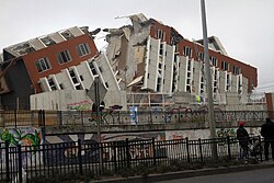
| 11 [56] | Chile, O'Higgins Region, 61 km NW of Santa Cruz | 6.9 | 11.0 | VII | The 2010 Pichilemu earthquakes are likely aftershocks of the 8.8 event on February 27. Both of them occurred within sixteen minutes of each other. The first earthquake occurred minutes before Sebastián Piñera was sworn in as President of Chile. [57] One person died of a heart attack in Talca, Maule Region. [58] | 1 | - |
| 11 [59] | Chile, O'Higgins Region, 52 km NW of Santa Cruz | 7.0 | 18.0 | VII |
| 11 [60] | Chile, O'Higgins Region, 61 km WNW of Santa Cruz | 6.0 | 31.5 | VI | Aftershock of the 2010 Pichilemu earthquakes that occurred eleven minutes after the 7.0 event | - | - |
| 14 [61] | Indonesia, Seram, 202 km NNW of Amahai | 6.4 | 53.0 | V | - | - | - |
| 14 [62] |  Japan, Fukushima Prefecture, 592 km ENE of Namie Japan, Fukushima Prefecture, 592 km ENE of Namie | 6.5 | 32.0 | VI | - | - | - |
| 15 [63] | Chile, Ñuble Region, 76 km NW of Quirihue | 6.2 | 14.0 | IV | Aftershock of the 8.8 earthquake on February 27 | - | - |
| 16 [64] | Chile, Biobío Region, 52 km NNW of Tomé | 6.7 | 18.0 | V | Aftershock of the 8.8 earthquake on February 27 | - | - |
| 20 [65] |  Papua New Guinea, New Ireland Province Papua New Guinea, New Ireland Province | 6.6 | 414.6 | - | - | - | - |
| 25 [66] |  Philippines, Occidental Mindoro, 2 km SW of Lubang Philippines, Occidental Mindoro, 2 km SW of Lubang | 6.0 | 16.6 | V | - | - | - |
| 26 [67] | Chile, Atacama Region, 69 km N of Vallenar | 6.3 | 42.0 | V | - | - | - |
| 28 [68] | Chile, Maule Region, 88 km W of Constitución | 6.0 | 29.9 | IV | Aftershock of the 8.8 earthquake on February 27 | - | - |
| 30 [69] |  India, Andaman and Nicobar Islands, 217 km N of Bombooflat India, Andaman and Nicobar Islands, 217 km N of Bombooflat | 6.6 | 30.9 | VI | - | - | - |