This is a list of earthquakes in 2021. Only earthquakes of magnitude 6 or above are included, unless they result in damage and/or casualties, or are notable for some other reason. All dates are listed according to UTC time. Maximum intensities are indicated on the Mercalli intensity scale. The year 2021 was a very active period for global seismicity, with 19 major earthquakes, three of which were over 8.0, and was also the most seismically active since 2007. There were a total of 2,476 fatalities, with the majority from a M 7.2 in Haiti. Fatalities occurred in every month of the year. Earthquake activity was lowest in June, while August was the most active and deadliest month. Major events also took place in Indonesia, Japan, China, Pakistan, Mexico and Peru. A M 7.3 quake in China was the most intense event of the year (MMI X, Extreme). A rare 5.9 magnitude earthquake struck Victoria, Australia in September.
The 2021 Khövsgöl earthquake was the strongest earthquake to hit Mongolia since 1967. A number of public buildings around Khövsgöl lake and as far south as Mörön were damaged with cracked walls and broken windows. In Mörön, 59 people had to be treated for symptoms such as heart problems and high blood pressure.[16][17][18]
The 2021 West Sulawesi earthquake caused widespread damage in Mamuju Regency, including hotel and hospital collapses. Landslides also occurred and various roads were blocked. 105 people died, more than 6,400 others injured, and three missing.[23][24][25]
Over 3,000 houses were destroyed and 30,000 others were damaged in San Juan province.[32] Power disruptions were reported as well as landslides and damaged roads. Twenty people were injured, one of them seriously.[16][33][34]
A few buildings in Talaud Islands Regency were damaged.[36] In the neighboring Philippines, nine buildings, including three schools and two health facilities, were damaged on the island of Mindanao.[37]
The earthquake was felt in the capital Yerevan, where more than 3,000 buildings were reported to have been damaged, and some collapsed.[82] At least 27 people were injured.[83][84][85]
The 2021 Fukushima earthquake caused power outages for 800,000 houses, damage to buildings and damage to a major expressway in Fukushima. Three people were confirmed dead, and 185 people were injured, 12 of them seriously.[87][88][89] Maximum intensity on the JMA scale reached Shindo 6+. It was an aftershock of the 2011 Tōhoku earthquake.[90]
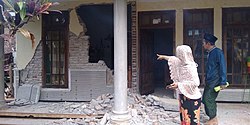
In the 2021 Sisakht earthquake, at least 1,206 houses were destroyed, while 2,956 others were damaged.[96] At least 63 people sustained injuries, most of them in Yasuj.[97]
Various houses were damaged and some destroyed in Antioquia. One person died in Medellín after falling from a roof during the earthquake, while another died from a heart attack, and another died from a landslide at Retiro, and at least 6 people were injured.[107][108][109]
The 2021 Larissa earthquake damaged at least a hundred homes and other buildings in the area, including churches, were damaged. A disabled man was rescued with serious head injuries after being trapped in his house in Mesochori and later died in the hospital, while 11 other people were slightly injured.[111][112][113]
At least 1,789 buildings were damaged in 12 provinces, most of them slightly.[146] Twelve people were injured while fleeing in a panic, and also by jumping through windows.[147] A small tsunami was also observed, with heights of 6cm (0.20ft) in the Balearic Islands.[148]
Two homes cracked in the municipality of Ayutla de los Libres. Another three residences had fractured walls. Trees were downed and a roof detached off of a structure.[153]
The March 2021 Miyagi earthquake caused minor damage, and power outages for a few hundred houses. A tsunami advisory was issued for Miyagi, then canceled. Maximum intensity of Shindo 5+ was recorded.[156] 11 people were injured.[157] It was an aftershock of the 2011 Tōhoku earthquake.[158]
During the 2021 East Java earthquake, at least 1,491 houses were destroyed and 4,228 others were damaged.[176] Ten people were confirmed dead and more than 100 others were injured.[177][178]
The 2021 Assam earthquake caused moderate damage, such as fallen walls and cracked buildings, was reported near the epicenter. Ten people were injured and two deaths (due to heart attacks) were reported in the districts of Nagaon and Kamrup.[191][192] In neighbouring Bhutan, structural damage was also observed and two people were injured.[193]
The earthquake caused further damage at the same hospital, affected by May 2 event. Several electric generators were affected, resulting in power outages.[198]
The 2021 Dali earthquake caused some buildings to collapse, trapping people under the rubble, and others were damaged. Three people were killed and 32 others injured.[224]
At least 267 houses collapsed while 859 buildings, including several schools, as well as several roads were damaged in the Rubavu District of Rwanda.[237] In neighboring Goma, Democratic Republic of the Congo, the earthquake flattened several buildings and ten people, including three children were injured by falling debris.[238][239][240]
Various old houses collapsed in Bukavu district, trapping some people under the rubble. Two children were killed by a falling wall, and three prisoners were injured.[249][250]
Homes in three villages were damaged by the earthquake. A 50cm (1.6ft) high tsunami added to the damage.[258][259] The tsunami was determined to have been triggered by an underwater landslide.[260]
During the 2021 Mala earthquake, Jorge Chávez International Airport sustained minor damage when ceiling tiles fell from the roof.[265] Several homes collapsed in Mala and a number of people fainted and fell from the stairs due to the shaking.[266] A 6-year-old boy died of a heart attack while evacuating and 20 others suffered injuries.[267][268]
Five people were killed, thirty others sustained injuries, and at least 20 houses destroyed in two villages during the 2021 Rasht earthquake.[287][288]
16 buildings were destroyed and 45 others were damaged in the districts of San Ignacio and Tabaconas. A 12-year old girl was injured and 50 people were left homeless.[294]
Two people injured, three homes collapsed and 61 others damaged.[299] A landslide occurred near Calatagan and some items were knocked off shelves in convenience stores. A sinkhole appeared beside a house in a barangay in Taal after the earthquake.[300][301]
Power outages were caused and many residents evacuated due to fear of a potential tsunami.[304] An elderly man died of shock and another died after a motorbike accident during the earthquake.[305][306] Two homes were seriously damaged while in another five, damage was moderate. Damage was also reported in one school and three worship locations.[307]
Moderate damage was reported near the epicenter, where various old houses were damaged, as well as Piura Cathedral. A total of 721 residents suffered injuries.[316] Two adults and a child had serious injuries after falling from height.[317]
The 2021 Haiti earthquake was the largest to strike the country since the 1842 Cap-Haïtien earthquake. More than 138,000 buildings were damaged or destroyed, most of them in Les Cayes and Nippes. 2,248 people were killed, 12,763 others were injured and 329 people remained missing. It is the deadliest earthquake of 2021.[340]
Fifteen homes collapsed in Altıntaş.[356] Bricks were dislodged and fell from a balcony and chimneys. The earthquake destroyed a barn and caused solar panels on a roof to explode.[357][358]
The 2021 Guerrero earthquake damaged or destroyed 8,700 buildings.[361] One person was killed in Coyuca de Benítez by a falling pole, and another in Acapulco.[362] Four more people died of heart attacks.[363][364][365] Around twenty people were also injured.[366] A seventh, indirect fatality occurred on September 9 in Acapulco due to a traffic accident.[367] A landside on September 10 in Cerro del Chiquihuite, Mexico City killed five more people, caused one injury and left two missing.[368][369] The suspected cause of the landslide was heavy rainfall and the quake which weakened soils on the hill.[370] A 14-year-old girl died from her injuries due to a collapsed wall on September 11.[371][372][373]
At least 623 houses collapsed and 226 others were damaged in 42 villages around the epicenter.[375] At least 23 people were injured during the quake.[376][377]
The 2021 Mansfield earthquake was one of the strongest earthquakes to hit mainland Australia. Power outages occurred and buildings were damaged in Melbourne. One person was injured by falling debris.[394]
The 2021 Arkalochori earthquake was the largest in Greece since the event in March. More than 5,000 buildings were damaged and landslides occurred in Heraklion.[398][399] A village was destroyed with only two buildings surviving. A man was killed and 35 people were injured.[400][401]
At least 42 people were killed, and 300 were injured during the 2021 Balochistan earthquake.[427] Around 70 buildings in Harnai collapsed, burying people. Some of the injured in critical condition were rushed to a hospital.[428][429]
The 2021 Chiba earthquake caused minor damage and power outages in the epicentral area, and at least 51 people were injured. There were two instances of building fires.[433][434] A maximum intensity of Shindo 5+ was recorded. It was the strongest earthquake to strike Tokyo since 2011.
This was the strongest earthquake in the US state since the 2018 Hawaii earthquake.[442] In Naalehu, objects fell off shelves and cracks appeared in drywalls.[443] Rockfalls were also reported in the Halemaʻumaʻu Crater.[443]
After the 2021 Bali earthquake, four people were killed by a landslide at Kintamani. A three-year-old girl was killed by falling debris.[459][460] 73 people were injured, seven of which sustained broken bones.[461] At least 70 collapsed homes were among the several hundred buildings affected.[462]
Three buildings were destroyed and 151 were damaged in Kızılören, Küçükmuhsine Sefaköy and Tepekent.[16] Two people were injured after falling from stairs.[486]
The 2021 Hormozgan earthquakes, spaced a few minutes apart can be considered as a doublet earthquake. Two people died, one by a falling utility pole, the other while fleeing his home.[491][492] Ninety-eight people suffered injuries, nine of them with heart attacks and broken limbs.[493] A number of homes were destroyed in Bandar Abbas and landslides occurred in the Geno Biosphere Reserve.[494]
In Hakha, Myanmar, the ceiling of a church partially collapsed.[506] In Bangladesh, one person was injured after jumping off the second floor of a building at Chittagong University,[507] and a four-storey apartment tilted to its side and struck a neighbouring building in Chawkbazar Thana.[508]
The 2021 Northern Peru earthquake caused around 2,592 buildings, including seven churches to collapse in Peru, where two people lost their lives; one by falling wood, the other from a heart attack, and 126 people were injured. Some damage was also reported in neighbouring Ecuador. On November 29, a bus crashed due to a landslide and fell of a cliff in Bongará Province, killing ten and injuring seven others.[510] Three people were injured in the La Jalca District, and 70% of the homes were damaged, according to the district's mayor. Many of the homes damaged were constructed of mud and stone.[511][512][513][514]
The 2021 Flores earthquake damaged at least 346 homes in Selayar Islands Regency of South Sulawesi. Three school buildings, two mosques, two places of worship and a village office were also damaged.[539] At least 173 people were injured,[540] seven of which when falling in a panic caused by a tsunami warning. A very small tsunami was observed, measuring at 7cm (2.8in). On December 23, an elderly man died in the hospital due to severe head injuries after being hit by falling debris from the earthquake.[541][542][543][544][545]
Some minor damage was reported, such as cracks in roads and broken glass. The earthquake also triggered a number of small landslides, and brought down a factory roof.[559][560][561]
Some twenty houses were damaged in Laos.[569] In Yunnan, China, the wall of a school collapsed and the ceiling of an office building fell.[570] Ten people were injured.[571]
Nine people were injured and at least 450 homes were destroyed at the Roundu District of Skardu. Water and power services were also disrupted.[16][574]
↑ "四川泸县6.0级地震已致两死 40多人送医"[More than 40 people have been sent to hospitals after the 6.0 magnitude earthquake in Luxian County, Sichuan Province]. Lianhe Zaobao. September 16, 2021. Retrieved September 16, 2021.
↑ Hao Jiangzhen; Yue Hongbin (September 20, 2021). "四川泸县6.0级地震最高烈度为8度"[Sichuan Luxian County 6.0 earthquake has the highest intensity of 8 degrees] (in Chinese). People's Daily. Xinhua News Agency. Retrieved September 21, 2021.
↑ "10月6日 岩手県沖の地震"[October 6 Earthquake off the coast of Iwate Prefecture](PDF) (in Japanese). jishin.go.jp. October 6, 2021. Retrieved December 29, 2021.
↑ "千葉県北西部を震源とする地震による被害及び消防機関等の対応状況(第5報)"[Damage caused by the earthquake with the epicenter in the northwestern part of Chiba Prefecture and the response status of fire departments (5th report)](PDF). 消防庁災害対策本部. October 8, 2021. Retrieved October 8, 2021.
↑ Luo Yitong (October 24, 2021). "地牛翻身!花莲1小时3起有感地震 女在锥麓古道遭落石砸到脚"[The ground cow turned over! Hualien 1 hour and 3 times after the earthquake, a woman was hit to her feet by a rock falling on the Zhuilu Ancient Road] (in Chinese). China Times. Retrieved October 24, 2021.
↑ "老挝发生6.0级地震 云南普洱暂无人员伤亡报告,后续灾情正在核查中"[There is a 6.0 magnitude earthquake in Laos. No casualties have been reported in Pu'er, Yunnan, and the follow-up disaster is under verification]. m.sohu.com (in Chinese). Retrieved December 25, 2021.
This page is based on this Wikipedia article Text is available under the CC BY-SA 4.0 license; additional terms may apply. Images, videos and audio are available under their respective licenses.