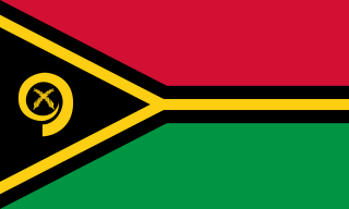
Vanuatu, officially the Republic of Vanuatu, is an island country in Melanesia, located in the South Pacific Ocean. The archipelago, which is of volcanic origin, is 1,750 km (1,090 mi) east of northern Australia, 540 km (340 mi) northeast of New Caledonia, east of New Guinea, southeast of Solomon Islands, and west of Fiji.

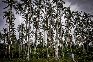
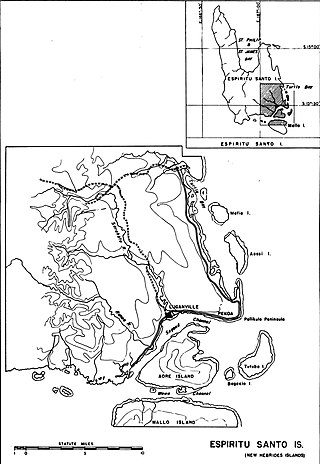
Espiritu Santo is the largest island in the nation of Vanuatu, with an area of 3,955.5 km2 (1,527.2 sq mi) and a population of around 40,000 according to the 2009 census.

Sanma is a province located in the Northern part of the nation of Vanuatu, occupying the nation's largest island, Espiritu Santo, which is located approximately 2,500 km northeast of Sydney, Australia. The name Sanma is derived from the initial letters of the main islands of (Espiritu) SANto and MAlo.

Luganville is the second largest city in Vanuatu after the capital Port Vila; it is located on the island of Espiritu Santo and has a population of 18,062 as of the 2020 census. Those on Vanuatu's northern islands who regard Luganville as their big city, particularly indigenous populations, call it Santo; rural residents of Espiritu Santo call it Kanal. Luganville served as a major base of operations for American troops during World War II.
Pentecost is one of the 83 islands that make up the South Pacific nation of Vanuatu.

Malo is an island in Vanuatu 3 km (1.9 mi) off the southern coast of Vanuatu's largest island, Espiritu Santo, in Sanma Province. It has a circumference of 55 km (34 mi) and an area of 180 km2 (69 sq mi). It is 17 kilometres or 11 miles long, and 13 kilometres or 8.1 miles across at its widest point. The highest point on the island is Mount Malo.
Sakao is an Oceanic language spoken on the northeast horn of Espiritu Santo, Vanuatu.

Aore is an island in Sanma Province, Vanuatu. It is located opposite Luganville on Espiritu Santo and has an area of 58 square kilometres (22 sq mi). The estimated terrain elevation above sea level is some 89 metres (292 ft).
Hog Harbour is a village in the island of Espiritu Santo in Vanuatu.
Araki is a small rocky island with an area of 2.5 km², located 3 miles off the southern shores of Espiritu Santo, which is the largest island in the nation of Vanuatu.

The 1986–87 South Pacific cyclone season was an event in the annual cycle of tropical cyclone formation. A total of 13 tropical cyclones developed during the season.
Severe Tropical Cyclone Anne was one of the most intense tropical cyclones within the South Pacific basin during the 1980s. The cyclone was first noted on January 5, 1988 as a weak tropical depression to the northeast of Tuvalu, in conjunction with the future Typhoon Roy in the Northern Hemisphere. Over the next few days, the system gradually developed while moving southwestward. Once it became a tropical cyclone, it was named Anne on January 8. The next day, Anne rapidly intensified, becoming the fourth major tropical cyclone to affect Vanuatu within four years. On January 11, Anne peaked in intensity while it was equivalent to a Category 5 on the Saffir–Simpson hurricane wind scale, and a Category 4 on the Australian tropical cyclone intensity scale. After turning southward on January 12, Anne struck New Caledonia, becoming the strongest tropical cyclone to affect the French Overseas Territory. The system subsequently weakened as it started to interact with Tropical Cyclone Agi. Anne weakened into a depression and was last noted on January 14 to the south-east of New Caledonia.
Severe Tropical Cyclone Esau was the strongest tropical cyclone to affect New Caledonia on record. A shallow tropical depression developed within the monsoon trough during 24 February 1992, about 370 km (230 mi) to the northeast of Port Vila, Vanuatu. Over the next day, the system gradually developed further as it moved towards the south-west under the influence of a northerly steering flow, before it passed over Pentecost Island in northern Vanuatu during 25 February. After passing over Pentecost the system continued to move towards the southwest and passed near the island of Malampa before the depression turned northwards and executed a small clockwise loop as it passed over the island of Espiritu Santo. The system was subsequently named Esau during 26 February, after it had developed into a tropical cyclone. Over the next couple of days, the system moved south-westwards towards Australia and away from the islands of Vanuatu. Esau subsequently executed a second clockwise loop during 28 February, before it peaked as a Category 4 tropical cyclone on both the Australian tropical cyclone intensity scale and the Saffir-Simpson hurricane wind scale. After it had peaked the system moved south-eastwards and threatened Southern Vanuatu, before turning southwards and threatening the French overseas territory of New Caledonia. Esau made landfall on the French territory during 4 March, as a category 3 severe tropical cyclone before degenerating into an extratropical cyclone during 5 March. The systems remnants made landfall on New Zealand's North Island during 8 March, before they were last noted during the next day over the South Pacific Ocean.

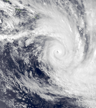
Tropical Cyclone Sose was a moderate storm system that chiefly impacted the island nation of Vanuatu in early April 2001. The developing cyclone was first detected on April 3, while situated well to the northeast of Vanuatu. As atmospheric conditions became more conducive to intensification, the disturbance gradually consolidated as it drifted toward the west-southwest. After receiving the name Sose on April 5, the cyclone was driven southeastward, passing just west of Espiritu Santo and neighboring islands. Although it never made landfall, Sose was particularly expansive, producing a wide area of gale-force winds. The cyclone peaked in strength between April 7 and 8 with maximum 10-minute sustained winds of 110 km/h (68 mph) and 1-minute sustained winds of 130 km/h (81 mph), placing it at Category 2 intensity on the Australian tropical cyclone intensity scale. Ultimately, stronger wind shear and an increasingly hostile upper-air pattern took their toll on the cyclone as it progressed due south; Sose lost tropical characteristics to the northeast of Norfolk Island by April 12. The extratropical remnants of Sose continued into the Tasman Sea.
Sakao, locally known as Lathi or Laðhi, is an uninhabited island in Vanuatu. It is located off the northeastern shore of Vanuatu's largest island Espiritu Santo in Sanma Province, and off the southeastern shore of Vanuatu's second-largest island, Malakula. The island has given its name to the Sakao language, spoken in the nearby area of Port-Olry.
Mavia is an inhabited island in Sanma Province of Vanuatu in the Pacific Ocean. The island lies off the eastern coast of Espiritu Santo. The estimated terrain elevation above the sea level is some 63 metres.
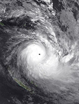
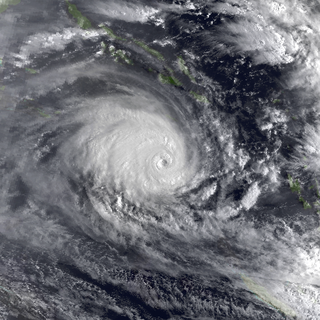
Severe Tropical Cyclone Harold was a very powerful tropical cyclone which caused widespread destruction in the Solomon Islands, Vanuatu, Fiji, and Tonga during April 2020. It was the first Category 5 tropical cyclone in 2020. The seventh named storm of the 2019–20 Australian region cyclone season, eighth named storm, and fourth severe tropical cyclone of the 2019–20 South Pacific cyclone season, Harold was first noted as a developing tropical low within a trough of low pressure during April 1, while it was located to the east of Papua New Guinea. Over the next day, the system moved south-eastwards over the Solomon Sea, before it was classified as a tropical cyclone and named Harold by the Australian Bureau of Meteorology. The system moved into the Fiji Meteorological Service's area of responsibility on April 2 and began to explosively intensify by April 3, reaching Category 4 status by April 4 on both scales. The next day, it further strengthened into a Category 5 severe tropical cyclone, the highest rating on the Australian scale. It made landfall on Espiritu Santo on April 6 and the next day, strengthening to its peak intensity, attaining Category 5-equivalent intensity on the Saffir–Simpson scale before making landfall on Pentecost Island. Moving east, it weakened below Category 5 intensity on both scales over subsequent days. It regained Category 5 severe tropical cyclone status while passing south of Fiji, before weakening and becoming extratropical on April 9.
Canal du Segond, also known as Canal Pekoa and in English Segond Channel, literally "Second Channel," separates the island of Aore from the city of Luganville on main island of Espiritu Santo, Vanuatu.
