List of islands of Vanuatu

Last updated

Nh-map.png

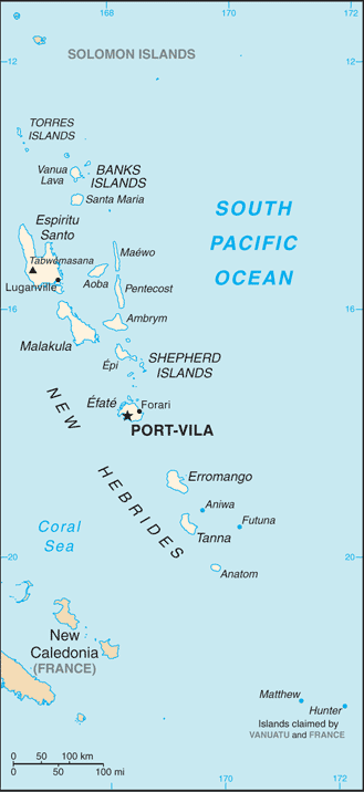
This is a list of islands of Vanuatu by province, largely from north to south, subdivided by archipelago when appropriate. Vanuatu is usually said to contain 83 islands.

Islands

Related Research Articles

<span class="mw-page-title-main">Air Vanuatu</span> Flag carrier of Vanuatu

Air Vanuatu is an airline with its head office in Air Vanuatu House, Port Vila, Vanuatu. It is Vanuatu's national flag carrier, operating to Australia, New Zealand, New Caledonia and points in the South Pacific. Its main base is Bauerfield International Airport, Port Vila. In May 2024 the airline was placed into voluntary administration by the Government of Vanuatu.

<span class="mw-page-title-main">Tafea Province</span> Province of Vanuatu

Tafea is the southernmost of the six provinces of Vanuatu. The name is an acronym for the five main islands that make up the province: Tanna, Aneityum, Futuna, Erromango and Aniwa.

<span class="mw-page-title-main">Torba Province</span> Province of Vanuatu

Torba is the northernmost and least populous province of Vanuatu. It consists of the Banks Islands and the Torres Islands.

<span class="mw-page-title-main">Matthew Island and Hunter Island</span> Islands of New Caledonia

Hunter Island and Matthew Island are two small and uninhabited volcanic islands in the South Pacific, located 300 kilometres (190 mi) east of New Caledonia and south-east of Vanuatu archipelago. Hunter Island and Matthew Island, 70 km (43 mi) apart, are claimed by Vanuatu as part of Tafea Province, and considered by the people of Aneityum part of their custom ownership, and as of 2007 were claimed by France as part of New Caledonia.

<span class="mw-page-title-main">Banks Islands</span> Group of islands in Torba, Vanuatu

The Banks Islands are a group of islands in northern Vanuatu. Together with the Torres Islands to their northwest, they make up the northernmost province of Torba. The island group lies about 40 km (25 mi) north of Maewo, and includes Gaua and Vanua Lava, two of the 13 largest islands in Vanuatu. In 2009, the islands had a population of 8,533. The island group's combined land area is 780 km2.

<span class="mw-page-title-main">Aneityum</span> Island in Vanuatu

Aneityum is the southernmost island of Vanuatu, in the province of Tafea.

<span class="mw-page-title-main">Southern Oceanic languages</span> Subgroup of the Oceanic branch of the Austronesian language family

The Southern Oceanic languages are a linkage of Oceanic languages spoken in Vanuatu and New Caledonia. It was proposed by John Lynch in 1995 and supported by later studies. It appears to be a linkage rather than a language family with a clearly defined internal nested structure.

<span class="mw-page-title-main">Vanua Lava</span> Island in Vanuatu

Vanua Lava is the second largest of the Banks Islands in Torba Province, Vanuatu, after slightly larger Gaua.

<span class="mw-page-title-main">Mota Lava</span> Island in Vanuatu

Mota Lava or Motalava is an island of the Banks group, in the north of Vanuatu. It forms a single coral system with the small island of Ra.

<span class="mw-page-title-main">Mota (island)</span> Island in Vanuatu

Mota is an island in the Banks group of northern Vanuatu. Its population – today about 700 people – speak the Mota language, which Christian missionaries of the Anglican Church used as a lingua franca in parts of Melanesia.

<span class="mw-page-title-main">Mota Lava Airport</span> Airport in Aplow

Mota Lava Airport is an airport located on the island of Mota Lava, one of the Banks Islands in the Torba province in Vanuatu. Also known as Valua Airport, it is located on the eastern end of Motalava island, near the village of Aplow.

<span class="mw-page-title-main">Merelava</span> Island in Vanuatu

Merelava is an island in the Banks Islands of the Torba Province of northern Vanuatu.

<span class="mw-page-title-main">Ra (island)</span> Island in Vanuatu

Rah or Ra is a small coral islet of 0.5 km2 (0.19 sq mi), located in the Banks group of northern Vanuatu. The same name also refers to the single village which is situated within this islet.

<span class="mw-page-title-main">Vot Tande</span> Island in Torba Province, Vanuatu

Vot Tande is an uninhabited islet of the Banks Islands of northern Vanuatu. It is located about 50 km (31 mi) due north of the island of Mota Lava. The islet of Vot Tande has never been inhabited. It is host to thousands of sea birds—especially frigatebirds, which have given their name to the islet. It consists of two islands. The highest point of either of the islands is 64 meters above sea level.

Sakao, locally known as Lathi or Laðhi, is an uninhabited island in Vanuatu. It is located off the northeastern shore of Vanuatu's largest island Espiritu Santo in Sanma Province, and off the southeastern shore of Vanuatu's second-largest island, Malakula. The island has given its name to the Sakao language, spoken in the nearby area of Port-Olry.

<span class="mw-page-title-main">Rowa Islands</span> Group of islands in Vanuatu

Rowa Islands are an uninhabited archipelago in Torba Province of Vanuatu in the Pacific Ocean. The Rowa are a part of larger Banks Islands archipelago. The islands are a natural border between Melanesia and Polynesia; they are one of the most beautiful places in the South Pacific Ocean and an integral part of a vast system of atolls and reefs.

Leneu is a small uninhabited island in Torba Province of Vanuatu in the Pacific Ocean. Leneu lies close to Sola on Vanua Lava and is a part of Banks Islands archipelago.

Erueti Lep is a small uninhabited island in the Pacific Ocean, a part of the Shefa Province of Vanuatu.

Ekapum Lep is a small uninhabited island in the Pacific Ocean, a part of the Shefa Province of Vanuatu.

Iriwiti Lep is a small uninhabited island in the Pacific Ocean, a part of the Shefa Province of Vanuatu.