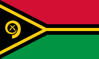
Vanuatu, officially the Republic of Vanuatu, is an island country in Melanesia, located in the South Pacific Ocean. The archipelago, which is of volcanic origin, is 1,750 km (1,090 mi) east of northern Australia, 540 km (340 mi) northeast of New Caledonia, east of New Guinea, southeast of Solomon Islands, and west of Fiji.

The Samoa national association football team represents Samoa in men's international football and it is controlled by the Football Federation Samoa, the governing body for football in Samoa. Samoa's home ground is Toleafoa J. S. Blatter Soccer Stadium in Apia. It was known as the Western Samoa national football team until 1997.

Luganville is the second largest city in Vanuatu after the capital Port Vila; it is located on the island of Espiritu Santo and has a population of 18,062 as of the 2020 census. Those on Vanuatu's northern islands who regard Luganville as their big city, particularly indigenous populations, call it Santo; rural residents of Espiritu Santo call it Kanal. Luganville served as a major base of operations for American troops during World War II.

Malo is an island in Vanuatu 3 km (1.9 mi) off the southern coast of Vanuatu's largest island, Espiritu Santo, in Sanma Province. It has a circumference of 55 km (34 mi) and an area of 180 km2 (69 sq mi). It is 17 kilometres or 11 miles long, and 13 kilometres or 8.1 miles wide. The highest point on the island is Mount Malo.

Nagriamel is a political party in Vanuatu.

Aore Island is an island in Sanma Province, Vanuatu. It is located opposite Luganville on Espiritu Santo and has an area of 58 square kilometres (22 sq mi). The estimated terrain elevation above sea level is some 89 metres (292 ft).
The North Vanuatu languages form a linkage of Southern Oceanic languages spoken in northern Vanuatu.
Ratua, situated in the Vanuatu archipelago, is a 146-acre (59 ha) island located south of Espiritu Santo, between Aore and Malo islands.

Aore Adventist Academy is a coeducational Christian secondary school in Aore, Vanuatu. It first opened in 1927 as 'New Hebrides Training School.' Its educational status varied over the decades. In 1974, the Aore School was upgraded to that of a high school, and was renamed Aore Adventist High School. It was previously Parker Missionary School. In 1994, the school's board changed the name to Aore Adventist Academy.
Aore is a recently extinct Oceanic language spoken on Aore Island, just off Espiritu Santo Island in Vanuatu.
General elections were held in Vanuatu on 22 January 2016. The previous elections occurred in October 2012. The president of Vanuatu, Baldwin Lonsdale, dissolved the Parliament of Vanuatu in November 2015. This occurred after the conviction of 14 parliamentarians for bribery. The convicted MPs include former Prime Ministers Serge Vohor and Moana Carcasses Kalosil. The president called for a snap election to form a new government.
Havo Molisale was a Vanuatuan politician. Molisale was first elected to the Parliament of Vanuatu in 2008 from the Malo/Aore Constituency in Sanma Province. He won re-election to Parliament in the 2012 and January 2016 general elections. He was a member of the Nagriamel political party.
Malokilikili Island is an inhabited island in Sanma Province of Vanuatu in the Pacific Ocean. Malokilikili lies off the eastern coast of Malo Island.
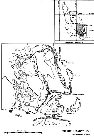
Mavea, or locally Mav̈ea, is an inhabited island in Sanma Province of Vanuatu in the Pacific Ocean. The island lies off the eastern coast of Espiritu Santo. The estimated terrain elevation above the sea level is some 63 metres.
Varo is a small uninhabited island in the Malampa Province of Vanuatu.
Malotina is a small uninhabited island in Sanma Province of Vanuatu in the Pacific Ocean.
Leumanang is a small uninhabited island in the Malampa Province of Vanuatu. Leumanang is a part of the Maskelyne group off south Malekula.
The Espiritu Santo languages are a group of North Vanuatu languages spoken on Espiritu Santo Island in northern Vanuatu. Tryon (2010) considers the Espiritu Santo languages to be a coherent group.
The Narave or Naravé pig is a type of domestic pig native to northern Vanuatu. Navare pigs are pseudohermaphrodite (intersex) male individuals that are kept for ceremonial purposes.
