Vanuatu, officially the Republic of Vanuatu, is an island country in Melanesia, located in the South Pacific Ocean. The archipelago, which is of volcanic origin, is 1,750 km (1,090 mi) east of northern Australia, 540 km (340 mi) northeast of New Caledonia, east of New Guinea, southeast of Solomon Islands, and west of Fiji.
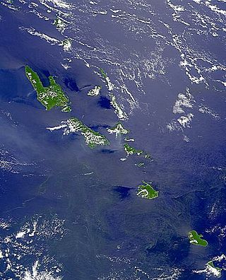
Vanuatu is a nation and group of islands in the South Pacific Ocean. It is composed of over 80 islands with 2,528 kilometres (1,571 mi) of coastline and a total surface area of 12,189 square kilometres (4,706 sq mi). It's a small country with a total size of 12,189 km2 (4,706 sq mi). Due to the spread out islands it has the 39th largest Exclusive Economic Zone of 663,251 km2 (256,083 sq mi).

Port Vila, or simply Vila, is the capital and largest city of Vanuatu. It is located on the island of Efate.
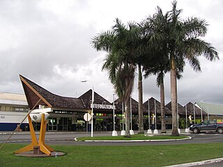
Bauerfield International Airport is an airport located in Port Vila, Vanuatu. The airport is relatively small in size, but its runway has the capability and length to accept jets up to the Airbus A330. It serves as the hub for Vanuatu's flag carrier airline, Air Vanuatu.
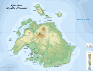
Efate is an island in the Pacific Ocean which is part of the Shefa Province in Vanuatu. It is also known as Île Vate.
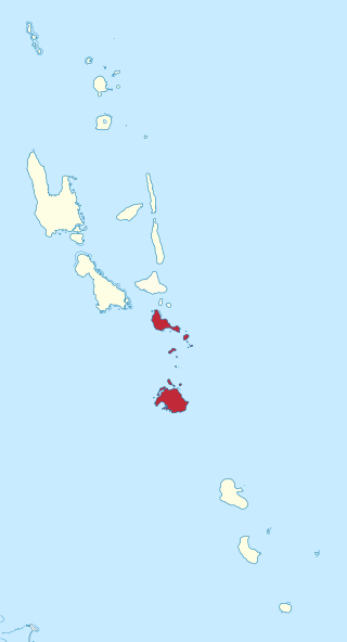
Shefa is one of the six provinces of Vanuatu, located in the center of the country and including the islands of Epi and Efate and the Shepherd Islands. The province's name is derived from the initial letters of SHepherd and EFAte. It has a population of 78,723 people and an area of 1,455 km2. Its capital is Port Vila, which is also the capital of the nation.
The Central Vanuatu languages form a linkage of Southern Oceanic languages spoken in central Vanuatu.
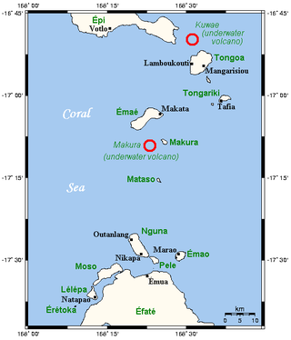
The Shepherd Islands are a group of islands lying between the larger islands of Epi and Éfaté, in the Shefa province of Vanuatu. The aggregate land area is 88 square kilometres. They were named by Captain Cook after Anthony Shepherd, a British astronomer and friend of Cook.

The Southern Oceanic languages are a linkage of Oceanic languages spoken in Vanuatu and New Caledonia. It was proposed by John Lynch in 1995 and supported by later studies. It appears to be a linkage rather than a language family with a clearly defined internal nested structure.

North Efate, also known as Nakanamanga or Nguna, is an Oceanic language spoken on the northern area of Efate in Vanuatu, as well as on a number of islands off the northern coast – including Nguna, and parts of Tongoa, Emae and Epi.

Port Vila Football League is the top division football league in Port Vila, Vanuatu. It consists of three competitions: Port Vila Premier League, Port Vila First Division and the Port Vila Second Division. The league's domestic cup is the Port Vila FA Cup, in which all 3 divisions compete in.
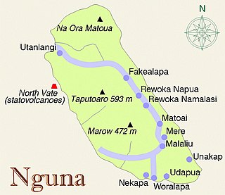
Nguna Island is an outer island off the north coast of Efate, Vanuatu in Undine Bay.
Moso Island is an island off the northwest coast of Efate in Vanuatu, in Shefa Province. It is separated from Efate by Namoso Passage, which is 200 metres (660 ft) wide at its narrowest point.

Ifira is an offshore island of Efate, located in Shefa Province of Vanuatu in the Pacific Ocean.

Eretoka is a small uninhabited island in Shefa Province of Vanuatu in the Pacific Ocean. The island lies off the western coast of Efate Island. There is a lighthouse built in the 1960s.
Tongoa Island is an inhabited island in Shefa Province of Vanuatu in the Pacific Ocean.
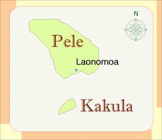
Kakula is a small uninhabited islet in Shefa Province of Vanuatu in the Pacific Ocean. The island is a tourist destination.
Erakor Island is a small island in the Pacific Ocean on the outskirts of Port-Vila, belonging to the Shefa Province of Vanuatu. The island is home to the Erakor Island Resort and Spa, and is a popular destination for western tourists.
Erueti Lep is a small uninhabited island in the Pacific Ocean, a part of the Shefa Province of Vanuatu.

Squatting in the Republic of Vanuatu is the occupation of unused land or derelict buildings without the permission of the owner. After independence in 1980, informal settlements developed in cities such as Luganville and the capital Port Vila. Land in Vanuatu is either custom land owned by indigenous peoples or public land owned by the republic.

