
Ambrym is a volcanic island in Malampa Province in the archipelago of Vanuatu. Volcanic activity on the island includes lava lakes in two craters near the summit.
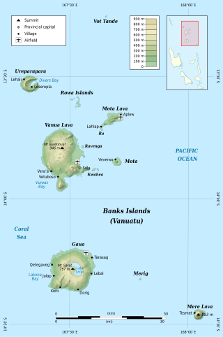
The Banks Islands are a group of islands in northern Vanuatu. Together with the Torres Islands to their northwest, they make up the northernmost province of Torba. The island group lies about 40 km (25 mi) north of Maewo, and includes Gaua and Vanua Lava, two of the 13 largest islands in Vanuatu. In 2009, the islands had a population of 8,533. The island group's combined land area is 780 km2.
Shefa is one of the six provinces of Vanuatu, located in the center of the country and including the islands of Epi and Efate and the Shepherd Islands. The province's name is derived from the initial letters of SHepherd and EFAte. It has a population of 78,723 people and an area of 1,455 km2. Its capital is Port Vila, which is also the capital of the nation.
Futuna is an island in the Tafea province of Vanuatu. It is the easternmost island in the country.

Epi is an island in Shefa Province, Vanuatu, at the north end of the Shepherd Islands.
The Shepherd Islands are a group of islands lying between the larger islands of Epi and Éfaté, in the Shefa province of Vanuatu. The aggregate land area is 88 square kilometres. They were named by Captain Cook after Anthony Shepherd, a British astronomer and friend of Cook.

Paama is a small island in Malampa Province, Vanuatu.

North Efate, also known as Nakanamanga or Nguna, is an Oceanic language spoken on the northern area of Efate in Vanuatu, as well as on a number of islands off the northern coast – including Nguna, and parts of Tongoa, Emae and Epi.
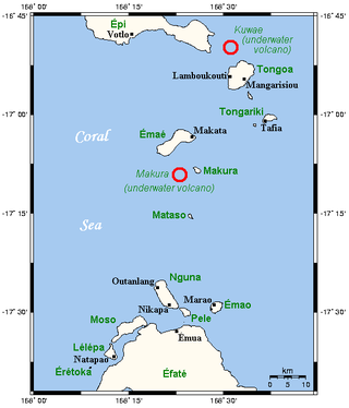
Kuwae was a landmass that existed in the vicinity of Tongoa and was destroyed by volcanic eruption in fifteenth century, probably through caldera subsidence. The exact location of the caldera is debated. A submarine caldera, now known as Kuwae caldera that is located between the Epi and Tongoa islands is a potential candidate. Kuwae Caldera cuts through the flank of the Tavani Ruru volcano on Epi and the northwestern end of Tongoa. Another potential candidate is a proposed caldera between Tongoa and Tongariki.
In Oceania, Google Street View is available in most parts of Australia and New Zealand.
Emae, or Fakamae, is a Polynesian outlier language of Vanuatu.

Mataso is an island in the Shefa of Vanuatu in the Pacific Ocean. The island is a part of Shepherd Islands archipelago.
There are two large sulfate spikes caused by mystery volcanic eruptions in the mid-1400s: the 1452/1453 mystery eruption and 1458 mystery eruption. Before 2012, the date of 1458 sulfate spike was incorrectly assigned to be 1452 because previous ice core work had poor time resolution. The exact location of this eruption is uncertain, but possible candidates include the submerged caldera of Kuwae in the Coral Sea, Mount Reclus and Tofua caldera. The eruption is believed to have been VEI-7.
Tongoa Island is an inhabited island in Shefa Province of Vanuatu in the Pacific Ocean.
Ewose is a small uninhabited island in the Shefa Province of Vanuatu in the Pacific Ocean.
Laika is a small uninhabited island in the Pacific Ocean, a part of the Shepherd Islands archipelago in the Shefa Province of Vanuatu.
Tefala is a small uninhabited island in the Pacific Ocean, belonging to the Shefa Province of Vanuatu.
The 1452/1453 mystery eruption is an unidentified volcanic event that triggered the first large sulfate spike in the 1450s, succeeded by another spike in 1458 caused by another mysterious eruption. The eruption caused a severe volcanic winter leading to one of strongest cooling events in the Northern Hemisphere. This date also coincides with a substantial intensification of the Little Ice Age.

East of the Vanuatu island of Epi can be found a series of active underwater volcanic cones and a caldera which last erupted in 2023. These series of submarine volcanoes are generally referred as East Epi, and the 3 bigger cones have specific names, from west to east, Epi-A, Epi-B and Epi-C. All of these cones have had intermittent activity in this and the last century.

