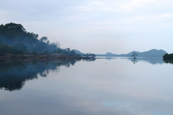
Vanuatu, officially the Republic of Vanuatu, is an island country in Melanesia, located in the South Pacific Ocean. The archipelago, which is of volcanic origin, is 1,750 km (1,090 mi) east of northern Australia, 540 km (340 mi) northeast of New Caledonia, east of New Guinea, southeast of Solomon Islands, and west of Fiji.

New Hebrides, officially the New Hebrides Condominium and named after the Hebrides in Scotland, was the colonial name for the island group in the South Pacific Ocean that is now Vanuatu. Native people had inhabited the islands for three thousand years before the first Europeans arrived in 1606 from a Spanish expedition led by Portuguese navigator Pedro Fernandes de Queirós. The islands were named by Captain James Cook in 1774 and subsequently colonised by both the British and the French.

Espiritu Santo is the largest island in the nation of Vanuatu, with an area of 3,955.5 km2 (1,527.2 sq mi) and a population of around 40,000 according to the 2009 census.
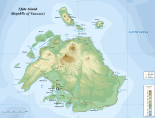
Efate is an island in the Pacific Ocean which is part of the Shefa Province in Vanuatu. It is also known as Île Vate.

Ambae, also known as Aoba, Omba, Oba, or Opa and formerly Lepers’ Island, is an island in the South Pacific island nation of Vanuatu, located near 15°30′S167°30′E, approximately 310 kilometres north-northwest of Vanuatu's capital city, Port Vila. It is also Vanuatu's largest active volcano.
The Mamanuca Islands of Fiji are a volcanic archipelago lying to the west of Nadi and to the south of the Yasawa Islands. The group, a popular tourist destination, consists of about 20 islands, but about seven of these are covered by the Pacific Ocean at high tide.

Malakula, also spelled Malekula, is the second-largest island in the nation of Vanuatu, formerly the New Hebrides, in Melanesia, a region of the Pacific Ocean.

Nacula is a hilly and volcanic island of the Yasawa Group in Fiji's Ba Province. It is the third-largest and is the second-farthest north in the group of islands.

San Andrés is a coral island in the Caribbean Sea. Politically part of Colombia, and historically tied to the United Kingdom, San Andrés and the nearby islands of Providencia and Santa Catalina form part of the department of San Andrés, Providencia and Santa Catalina; or The Raizal Islands. San Andrés, in the southern group of islands, is the largest of Colombia. The official languages of the department are Spanish, English, and San Andrés–Providencia Creole.
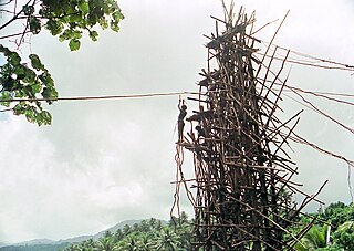
Land diving is a ritual performed by the men of the southern part of Pentecost Island, Vanuatu. Men jump off wooden towers around 20 to 30 meters high, with two tree vines wrapped around the ankles. The tradition has developed into a tourist attraction. According to the Guinness World Records, the g-force experienced by those at their lowest point in the dive is the greatest experienced in the non-industrialized world by humans.
Netball in Niue is a popular local sport. Games are most often played by girls on Saturdays between June and August, though games can be played at all times of the year. Most of the netball is played on high school athletic grounds.

Bob Halstead, has made significant contributions to the sport of scuba diving in a multitude of capacities: photographer, author of eight diving books, early innovator in the development of dive tourism, pioneer in the dive liveaboard industry, diving instructor and educator, marine-life explorer and influential diving industry commentator. An ardent diver since 1968, Halstead has over 10,000 logged dives.

Fishing is important to the national economy of Vanuatu. It is the main source of income for many in the islands and Vanuatu's biggest export. According to 2009 figures, approximately 77% of households in Vanuatu are involved in fishing activity. According to 2005 figures, Vanuatu caught 151,080 fish in that year, with frozen fish accounted for half of Vanuatu's commodity exports.

Pélé, sometimes spelled Pele in English, is a volcanic island located 11,2 miles north of the island of Éfaté in the Shefa Province of the Republic of Vanuatu. It has a total area of 1.7 square miles, Pélé is inhabited by about 200-220 Ni-Vanuatu villagers residing in the four villages: Worsiviu, Worearu, Piliura, and Launamoa.
Gonubalabala Island (on maps as Gona Bara Bara) is an island on the southern side of East Channel, Milne Bay Province, Papua New Guinea. It is located South east of Logea Island. It is a home island of the Mailulu clan.
Uluveo Island is a small, inhabited island in Malampa Province of Vanuatu in the Pacific Ocean. Uluveo is a part of the Maskelyne Islands archipelago.
Leumanang is a small uninhabited island in the Malampa Province of Vanuatu. Leumanang is a part of the Maskelyne group off south Malekula.
The Malakula languages are a group of Central Vanuatu languages spoken on Malakula Island in central Vanuatu. Unlike some earlier classifications, linguist and Oceanic languages specialist John Lynch (2016) considered the Malakula languages to form a coherent group.

Naval Advance Base Espiritu Santo or Naval Base Espiritu Santo, most often just called Espiritu Santo, was a major advance Naval base that the U.S. Navy Seabees built during World War II to support the Allied effort in the Pacific. The base was located on the island of Espiritu Santo in the New Hebrides, now Vanuatu, in the South Pacific. The base also supported the U.S. Army and Army Air Corps, U.S. Coast Guard, and US Marine Corps. It was the first large advance base built in the Pacific. By the end of the war it had become the second-largest base in the theater. To keep ships tactically available there was a demand for bases that could repair and resupply the fleet at advance locations, rather than return them to the United States. Prior to December 7th, Pearl Harbor was the U.S. fleet's largest advance base in the Pacific. Espiritu became capable of all aspects necessary to support the Fleet's operations from fleet logistics in fuel, food, and ammunition, to transport embarkation for combat operations or returning to the continental United States. The ship repair facilities and drydocks were capable of attending to most damage and routine maintenance. Had it not existed, ships would have had to return to Pearl Harbor, Brisbane, or Sydney for major repairs and resupply. The base became a major R and R destination for the fleet.
Eta Rory is a politician from Vanuatu. She was a member of the Vanuatu Parliament from 2008 to 2012 and briefly held two ministerial positions. At the time she was the only female member of the parliament.