The Vanuatu rain forests are tropical and subtropical moist broadleaf forests ecoregion which includes the islands of Vanuatu, as well as the Santa Cruz Islands group of the neighboring Solomon Islands. It is part of the Australasian realm, which includes neighboring New Caledonia and the Solomon Islands, as well as Australia, New Guinea, and New Zealand.

Ambrym is a volcanic island in Malampa Province in the archipelago of Vanuatu. Volcanic activity on the island includes lava lakes in two craters near the summit.
Shefa is one of the six provinces of Vanuatu, located in the center of the country and including the islands of Epi and Efate and the Shepherd Islands. The province's name is derived from the initial letters of SHepherd and EFAte. It has a population of 78,723 people and an area of 1,455 km2. Its capital is Port Vila, which is also the capital of the nation.

Ambae, also known as Aoba, Omba, Oba, or Opa and formerly Lepers’ Island, is an island in the South Pacific island nation of Vanuatu, located near 15°30′S167°30′E, approximately 310 kilometres north-northwest of Vanuatu's capital city, Port Vila. It is also Vanuatu's largest active volcano.

Malo is an island in Vanuatu 3 km (1.9 mi) off the southern coast of Vanuatu's largest island, Espiritu Santo, in Sanma Province. It has a circumference of 55 km (34 mi) and an area of 180 km2 (69 sq mi). It is 17 kilometres or 11 miles long, and 13 kilometres or 8.1 miles across at its widest point. The highest point on the island is Mount Malo.

Epi is an island in Shefa Province, Vanuatu, at the north end of the Shepherd Islands.
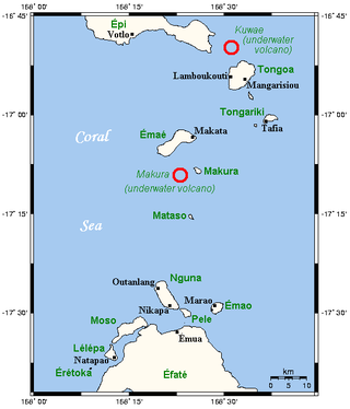
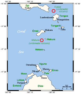
The Shepherd Islands are a group of islands lying between the larger islands of Epi and Éfaté, in the Shefa province of Vanuatu. The aggregate land area is 88 square kilometres. They were named by Captain Cook after Anthony Shepherd, a British astronomer and friend of Cook.

Emae is an island in the Shepherd Islands, Shefa, Vanuatu.

Gaua is the largest and second most populous of the Banks Islands in Torba Province in northern Vanuatu. It covers 342 km2.
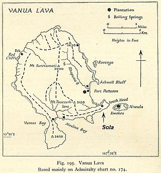
Vanua Lava is the second largest of the Banks Islands in Torba Province, Vanuatu, after slightly larger Gaua.
Kuwae was a landmass that existed in the vicinity of Tongoa and was destroyed by volcanic eruption in fifteenth century, probably through caldera subsidence. The exact location of the caldera is debated. A submarine caldera, now known as Kuwae caldera that is located between the Epi and Tongoa islands, is a potential candidate. Kuwae caldera cuts through the flank of the Tavani Ruru volcano on Epi and the northwestern end of Tongoa. Another potential candidate is a proposed caldera between Tongoa and Tongariki.
The Tongan megapode is a species of bird in the megapode family, Megapodiidae, currently endemic to Tonga. The species is also known as the Polynesian megapode, and as the Niuafo'ou megapode after the island of Niuafo'ou to which it was restricted for many years. The specific epithet honours British consul William Thomas Pritchard.

Mataso is an island in the Shefa of Vanuatu in the Pacific Ocean. The island is a part of Shepherd Islands archipelago.

Makura, locally known as Makira, is a small, inhabited island in Shefa Province of Vanuatu in the Pacific Ocean. Makura is a part of the Shepherd Islands archipelago.
Tongariki Island is an inhabited island in Shefa Province of Vanuatu in the Pacific Ocean. The island is a part of Shepherd Islands archipelago.
Lamen is an inhabited island in Shefa Province of Vanuatu in the Pacific Ocean. The island is a part of Shepherd Islands archipelago.
Ewose is a small uninhabited island in the Shefa Province of Vanuatu in the Pacific Ocean.
Laika or Laïka is a small uninhabited island in the Pacific Ocean, a part of the Shepherd Islands archipelago in the Shefa Province of Vanuatu.
Tefala is a small uninhabited island in the Pacific Ocean, belonging to the Shefa Province of Vanuatu.