
The Coral Sea Islands Territory is an external territory of Australia which comprises a group of small and mostly uninhabited tropical islands and reefs in the Coral Sea, north-east of Queensland, Australia. The only inhabited island is Willis Island. The territory covers 780,000 km2 (301,160 sq mi), most of which is ocean, extending east and south from the outer edge of the Great Barrier Reef and includes Heralds Beacon Island, Osprey Reef, the Willis Group and fifteen other reef/island groups. Cato Island is the highest point in the Territory.
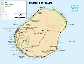
Nauru is a tiny phosphate rock island nation located in the South Pacific Ocean south of the Marshall Islands in Oceania. It is only 53 kilometres (33 mi) south of the Equator at coordinates 0°32′S166°55′E. Nauru is one of the three great phosphate rock islands in the Pacific Ocean—the others are Banaba in Kiribati and Makatea in French Polynesia.

The Philippine Sea is a marginal sea of the Western Pacific Ocean east of the Philippine Archipelago and the largest sea in the world, occupying an estimated surface area of 5 million square kilometers. The Philippine Sea Plate forms the floor of the sea. Its western border is the first island chain to the west, comprising the Ryukyu Islands in the northwest and Taiwan in the west. Its southwestern border comprises the Philippine islands of Luzon, Catanduanes, Samar, Leyte, and Mindanao. Its northern border comprises the Japanese islands of Honshu, Shikoku and Kyūshū. Its eastern border is the second island chain to the east, comprising the Bonin Islands and Iwo Jima in the northeast, the Mariana Islands in the due east, and Halmahera, Palau, Yap and Ulithi in the southeast. Its southern border is Indonesia's Morotai Island.

The Phi Phi Islands are an island group in Thailand between the large island of Phuket and the Straits of Malacca coast of Thailand. The islands are administratively part of Krabi Province. Ko Phi Phi Don is the largest and most populated island of the group, although the beaches of the second largest island, Ko Phi Phi Le are visited by many people as well. The rest of the islands in the group, including Bida Nok, Bida Nai, and Ko Mai Phai, are not much more than large limestone rocks jutting out of the sea. The islands are reachable by ferries, speedboats or long-tail boats, most often from Krabi town or from ports in Phuket Province.

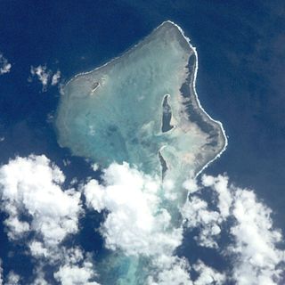
Vostok Island is an uninhabited coral island in the central Pacific Ocean, part of the Line Islands belonging to Kiribati. Other names for the island include Anne Island, Bostock Island, Leavitts Island, Reaper Island, Wostock Island or Wostok Island. The island was first sighted in 1820 by the Russian explorer Fabian Gottlieb von Bellingshausen, who named the island for his ship Vostok.
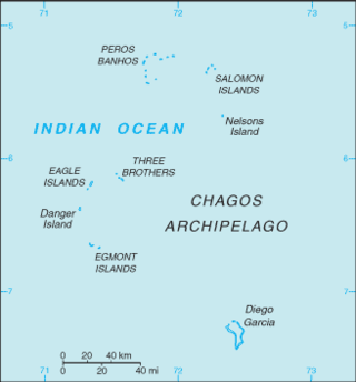
The British Indian Ocean Territory (BIOT) is an archipelago of 55 islands in the Indian Ocean, located south of India. It is situated approximately halfway between Africa and Indonesia. The islands form a semicircular group with an open sea towards the east. The largest, Diego Garcia, is located at the southern extreme end. It measures 60 square kilometres (23 sq mi) and accounts for almost three-quarters of the total land area of the territory. Diego Garcia is the only inhabited island and is home to the joint UK-US naval support facility. Other islands within the archipelago include Danger Island, Three Brothers Islands, Nelson Island, and Peros Banhos, as well as the island groups of the Egmont Islands, Eagle Islands, and the Salomon Islands.

Tanna is an island in Tafea Province of Vanuatu.
Kalpeni is an inhabited Atoll in the Union Territory of Lakshadweep, India. It has a distance of 287 km (178 mi) west of the city of Kochi.
Yanuca is an inhabited coral island in Fiji. It is administratively part of Serua province. The island has a land area of 1.5 square kilometres and reaches a maximum elevation of 100 metres. It is characterized by white sandy beaches and lush vegetation, and is now a camping site. To the east is the island of Beqa.

Epi is an island in Shefa Province, Vanuatu, at the north end of the Shepherd Islands.

The habitat of deep-water corals, also known as cold-water corals, extends to deeper, darker parts of the oceans than tropical corals, ranging from near the surface to the abyss, beyond 2,000 metres (6,600 ft) where water temperatures may be as cold as 4 °C (39 °F). Deep-water corals belong to the Phylum Cnidaria and are most often stony corals, but also include black and thorny corals and soft corals including the Gorgonians. Like tropical corals, they provide habitat to other species, but deep-water corals do not require zooxanthellae to survive.

Hiw is the northernmost island in Vanuatu, located in Torba Province.

Kadmat Island, also known as Cardamom Island, is a coral island belonging to the Amindivi subgroup of islands of the Lakshadweep archipelago in India. Measuring 9.3 kilometres (5.8 mi) in length, the island has a lagoon with a width of 1.5 kilometres (0.93 mi) covering an area of 25 square kilometres (9.7 sq mi). The ecological feature of the island is of coral reef with seagrass, and marine turtles which nestle here. The Ministry of Environment and Forests (India) has notified the island as a marine protected area for ensuring conservation of the island's animal, plant, or other type of organism, and other resources.
The Pasco Banks refers to a naturally occurring geological and marine formation in the south Pacific Ocean. The Pasco Banks is a long ridge-like seamount that rises from about 200 m to within 30 m of the ocean's surface. Covered in patchy coral reef, it attracts large schools of baitfish, mainly rainbow runner, which in turn are preyed upon by larger predatory fishes. This abundance of fish has made the Pasco Banks a popular and reliable fishing location for hundreds of years.

Fishing is important to the national economy of Vanuatu. It is the main source of income for many in the islands and Vanuatu's biggest export. According to 2009 figures, approximately 77% of households in Vanuatu are involved in fishing activity. According to 2005 figures, Vanuatu caught 151,080 fish in that year, with frozen fish accounted for half of Vanuatu's commodity exports.
The African Banks are the uninhabited northernmost islands of the Amirante Islands, of the Outer Islands of the Republic of Seychelles, in the western Indian Ocean.

Mataso is an island in the Shefa of Vanuatu in the Pacific Ocean. The island is a part of Shepherd Islands archipelago.
Rowa Islands are an uninhabited archipelago in Torba Province of Vanuatu in the Pacific Ocean. The Rowa are a part of larger Banks Islands archipelago. The islands are a natural border between Melanesia and Polynesia; they are one of the most beautiful places in the South Pacific Ocean and an integral part of a vast system of atolls and reefs.

Emao is a small inhabited island in Shefa Province of Vanuatu in the Pacific Ocean. It was also previously known as Montague Island.
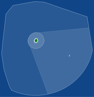
The Niue Nukutuluea Multiple-Use Marine Park is a marine protected area that encompasses the territorial waters and exclusive economic zone surrounding the Pacific island of Niue, covering a total area of 318,140 square kilometres (122,830 sq mi). Established in April 2022, it incorporated the Niue Moana Mahu Marine Protected Area and Beveridge Reef Nukutulueatama Special Management Area, which had been established in April 2020.

