
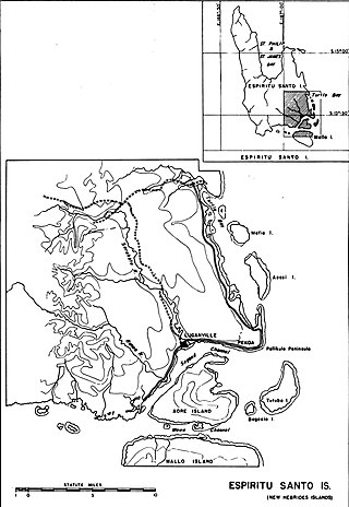
Espiritu Santo is the largest island in the nation of Vanuatu, with an area of 3,955.5 km2 (1,527.2 sq mi) and a population of around 40,000 according to the 2009 census.

Luganville is the second largest city in Vanuatu after the capital Port Vila; it is located on the island of Espiritu Santo and has a population of 18,062 as of the 2020 census. Those on Vanuatu's northern islands who regard Luganville as their big city, particularly indigenous populations, call it Santo; rural residents of Espiritu Santo call it Kanal. Luganville served as a major base of operations for American troops during World War II.
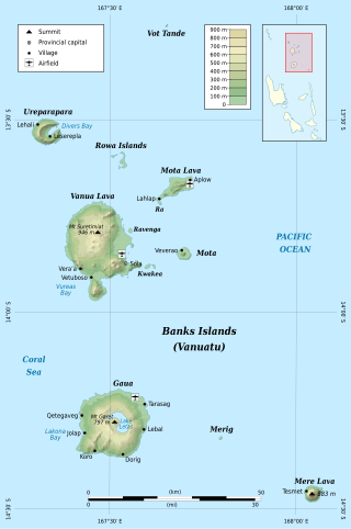
The Banks Islands are a group of islands in northern Vanuatu. Together with the Torres Islands to their northwest, they make up the northernmost province of Torba. The island group lies about 40 km (25 mi) north of Maewo, and includes Gaua and Vanua Lava, two of the 13 largest islands in Vanuatu. In 2009, the islands had a population of 8,533. The island group's combined land area is 780 km2.

Malakula Island, also spelled Malekula, is the second-largest island in the nation of Vanuatu, formerly the New Hebrides, in Melanesia, a region of the Pacific Ocean.

Santo International Airport is an airport in Luganville on Espiritu Santo in Vanuatu. The airport used to be called Santo-Pekoa International airport until it was renamed in the Vanuatu AIPV amendment released on 16 June 2021. Airports Vanuatu Limited provides aviation services for the airport.

Aore Island is an island in Sanma Province, Vanuatu. It is located opposite Luganville on Espiritu Santo and has an area of 58 square kilometres (22 sq mi). The estimated terrain elevation above sea level is some 89 metres (292 ft).

Tutuba is an island in Vanuatu, located off the coast of Vanuatu's largest island Espiritu Santo in Sanma Province.
Aese Island is a private uninhabited island in Sanma Province of Vanuatu in the Pacific Ocean.
Malokilikili Island is an inhabited island in Sanma Province of Vanuatu in the Pacific Ocean. Malokilikili lies off the eastern coast of Malo Island.
Mavea, or locally Mav̈ea, is an inhabited island in Sanma Province of Vanuatu in the Pacific Ocean. The island lies off the eastern coast of Espiritu Santo. The estimated terrain elevation above the sea level is some 63 metres.
Lataro is an uninhabited island in Sanma Province of Vanuatu in the Pacific Ocean.
Lataroa is an uninhabited island in Sanma Province of Vanuatu in the Pacific Ocean.
Thion is a small uninhabited island in Sanma Province of Vanuatu in the Pacific Ocean.
Malwepe is a small uninhabited island in Sanma Province of Vanuatu in the Pacific Ocean.
Malvapevu is a small uninhabited island in Sanma Province of Vanuatu in the Pacific Ocean.
Malparavu is a small uninhabited island in Sanma Province of Vanuatu in the Pacific Ocean.
Maltinerava is a small uninhabited island in Sanma Province of Vanuatu in the Pacific Ocean.
Dany Island is a tropical island in the Sanma Province of Vanuatu in the Pacific Ocean. The island is privately owned and run as a tourist resort for snorkeling, scuba diving, surfing, and deep-sea fishing.
The Espiritu Santo languages are a group of North Vanuatu languages spoken on Espiritu Santo Island in northern Vanuatu. Tryon (2010) considers the Espiritu Santo languages to be a coherent group.

Naval Advance Base Espiritu Santo or Naval Base Espiritu Santo, most often just called Espiritu Santo, was a major advance Naval base that the U.S. Navy Seabees built during World War II to support the Allied effort in the Pacific. The base was located on the island of Espiritu Santo in the New Hebrides, now Vanuatu, in the South Pacific. The base also supported the U.S. Army and Army Air Corps, U.S. Coast Guard, and US Marine Corps. It was the first large advance base built in the Pacific. By the end of the war it had become the second-largest base in the theater. To keep ships tactically available there was a demand for bases that could repair and resupply the fleet at advance locations, rather than return them to the United States. Prior to December 7th, Pearl Harbor was the U.S. fleet's largest advance base in the Pacific. Espiritu became capable of all aspects necessary to support the Fleet's operations from fleet logistics in fuel, food, and ammunition, to transport embarkation for combat operations or returning to the continental United States. The ship repair facilities and drydocks were capable of attending to most damage and routine maintenance. Had it not existed, ships would have had to return to Pearl Harbor, Brisbane, or Sydney for major repairs and resupply. The base became a major R and R destination for the fleet.

