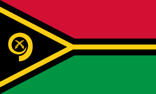
Vanuatu, officially the Republic of Vanuatu, is an island country in Melanesia, located in the South Pacific Ocean. The archipelago, which is of volcanic origin, is 1,750 km (1,090 mi) east of northern Australia, 540 km (340 mi) northeast of New Caledonia, east of New Guinea, southeast of Solomon Islands, and west of Fiji.
The history of Vanuatu spans over 3,200 years.

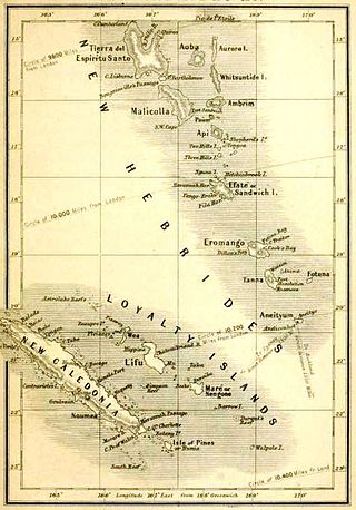
New Hebrides, officially the New Hebrides Condominium and named after the Hebrides Scottish archipelago, was the colonial name for the island group in the South Pacific Ocean that is now Vanuatu. Native people had inhabited the islands for three thousand years before the first Europeans arrived in 1606 from a Spanish expedition led by Portuguese navigator Pedro Fernandes de Queirós. The islands were named by Captain James Cook in 1774 and subsequently colonised by both the British and the French.

Malakula Island, also spelled Malekula, is the second-largest island in the nation of Vanuatu, formerly the New Hebrides, in Melanesia, a region of the Pacific Ocean.

Malo is an island in Vanuatu 3 km (1.9 mi) off the southern coast of Vanuatu's largest island, Espiritu Santo, in Sanma Province. It has a circumference of 55 km (34 mi) and an area of 180 km2 (69 sq mi). It is 17 kilometres or 11 miles long, and 13 kilometres or 8.1 miles across at its widest point. The highest point on the island is Mount Malo.

The Southern Oceanic languages are a linkage of Oceanic languages spoken in Vanuatu and New Caledonia. It was proposed by John Lynch in 1995 and supported by later studies. It appears to be a linkage rather than a language family with a clearly defined internal nested structure.

Honiara is the capital and largest city of Solomon Islands, situated on the northwestern coast of Guadalcanal. As of 2021, it had a population of 92,344 people. The city is served by Honiara International Airport and the seaport of Point Cruz, and lies along the Kukum Highway.

The Maskelyne Islands, often abbreviated as the Maskelynes, are a small chain of low islands that forms part of Vanuatu in the Pacific Ocean. Among the islands are Awei, Avock, Leumanang, Uluveo, and Vulai. Uluveo is the main island in the group and has three villages.

Mount Wonvara or Wonvagre is the highest point of Hiw, the northernmost island of Vanuatu. It has an elevation of 366 metres (1,201 ft).
Yeyenwu is a cave in Hiw, the northernmost island of Vanuatu. It has some notable stalactite formations.

Fishing is important to the national economy of Vanuatu. It is the main source of income for many in the islands and Vanuatu's biggest export. According to 2009 figures, approximately 77% of households in Vanuatu are involved in fishing activity. According to 2005 figures, Vanuatu caught 151,080 fish in that year, with frozen fish accounted for half of Vanuatu's commodity exports.

Pélé Island, sometimes spelled Pele in English, is a volcanic island located 11,2 miles north of the island of Éfaté in the Shefa Province of the Republic of Vanuatu. It has a total area of 1.7 square miles, Pélé is inhabited by about 200-220 Ni-Vanuatu villagers residing in the four villages: Worsiviu, Worearu, Piliura, and Launamoa. Pélé Island is a part of the MPA Nguna-Pele Marine Protected Area, which was established in 2003, and is a popular Vanuatuan diving location. The Nguna-Pele Marine Protected Area covers a total area of 11.5 sq. mi., including numerous reefs, sea grass beds, mangrove forests and intertidal lagoons. The Nguna-Pele Marine Protection Agency is located in the village of Piliura, and mounts an exhibition and sells T-shirts. Income from tourism is distributed by the Village Tourism Committee and supports aims as village water supply projects. The island can be visited daily by boat from the Paonangisu area by the town of Emua on Éfaté's north coast. There are also yachts available both from Emua and Nguna for day and overnight charters to the island. The island is nearly adjacent to the island of Nguna, with a small passage no deeper than 33 yards separating the two. It has a tropical climate and has a maximum elevation of 650 feet at its highest. Much of the island is extremely steep and rocks prevent you from walking along the coastline around the island. White sandy beaches are found in Piliura, Worearu, Laonamoa, and Sake. Overpopulation has led to a steady migration from Pele villages to southern Nguna in recent times.

Tutuba is an island in Vanuatu, located off the coast of Vanuatu's largest island Espiritu Santo in Sanma Province.

Linua is an island in the Torres Islands archipelago in Torba Province of Vanuatu in the southwestern Pacific Ocean.
Arseo Island is a small, uninhabited island in the Malampa Province of Vanuatu in the Pacific Ocean. The estimated terrain elevation above sea level is some 172 metres (564 ft). There are two small neighboring islands: Leumanang and Varo.
Sowan is a small, uninhabited island in the Malampa Province of Vanuatu.
Varo is a small uninhabited island in the Malampa Province of Vanuatu.
Uluveo Island is a small, inhabited island in Malampa Province of Vanuatu in the Pacific Ocean. Uluveo is a part of the Maskelyne Islands archipelago.
Vulaï is a small inhabited island in Malampa Province of Vanuatu in the Pacific Ocean. It is a part of the Maskelyne Islands archipelago. The island is also known as Harper Island.
Ottoville is a subdivision or district within the village of Tafuna, American Samoa.
