Vanuatu, officially the Republic of Vanuatu, is a Pacific island country located in the South Pacific Ocean. The archipelago, which is of volcanic origin, is 1,750 kilometres (1,090 mi) east of northern Australia, 540 kilometres (340 mi) northeast of New Caledonia, east of New Guinea, southeast of the Solomon Islands, and west of Fiji.

Port Vila, or simply Vila, is the capital and largest city of Vanuatu and is on the island of Efate.

Espiritu Santo is the largest island in the nation of Vanuatu, with an area of 3,955.5 km2 (1,527.2 sq mi) and a population of around 40,000 according to the 2009 census.
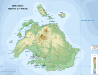
Efate is an island in the Pacific Ocean which is part of the Shefa Province in Vanuatu. It is also known as Île Vate.

Ambrym is a volcanic island in Malampa Province in the archipelago of Vanuatu. Volcanic activity on the island includes lava lakes in two craters near the summit.

Tanna is an island in Tafea Province of Vanuatu.

Shefa is one of the six provinces of Vanuatu, located in the center of the country and including the islands of Epi and Efate and the Shepherd Islands.

Ambae Island, also known as Aoba or Oba and formerly Leper's Island, is an island in the South Pacific island nation of Vanuatu, located near 15°30′S167°30′E, approximately 165 miles (266 km) NNW of Vanuatu's capital city, Port Vila.
The Central Vanuatu languages form a linkage of Southern Oceanic languages spoken in central Vanuatu.

Epi is an island in Shefa Province, Vanuatu, at the north end of the Shepherd Islands.

The Shepherd Islands are a group of islands lying between the larger islands of Epi and Éfaté, in the Shefa province of Vanuatu. The aggregate land area is 88 square kilometres. They were named by Captain Cook after Anthony Shepherd, a British astronomer and friend of Cook.

Paama is a small island in the Malampa Province, Vanuatu.

Emae is an island in the Shepherd Islands, Shefa, Vanuatu.
North Efate, also known as Nakanamanga or Nguna, is an Oceanic language spoken on the northern area of Efate in Vanuatu, as well as on a number of islands off the northern coast. Efate Island is an island in the center of Vanuatu, where North Efate subsists of a region that encompasses the regions bordered by Tuktuk Point in the South and Samoan point in the north. The influx of missionaries was characteristic of a change in indigenous perspectives where much of the traditions were destroyed or altered. Vanuatu has some of the highest language densities in the world. The population of speakers is recorded to be 9,500.

Moso Island is an island off the northwest coast of Efate in Vanuatu, in Shefa Province. It is separated from Efate by Namoso Passage, which is 200 metres (660 ft) wide at its narrowest point.
Emae is a Polynesian outlier language of Vanuatu.

Pélé Island, sometimes spelled Pele in English, is a volcanic island located 11,2 miles north of the island of Éfaté in the Shefa Province of the Republic of Vanuatu. It has a total area of 1.7 square miles, Pélé is inhabited by about 200-220 Ni-Vanuatu villagers residing in the four villages: Worsiviu, Worearu, Piliura, and Launamoa. Pélé Island is a part of the MPA Nguna-Pele Marine Protected Area, which was established in 2003, and is a popular Vanuatuan diving location. The Nguna-Pele Marine Protected Area covers a total area of 11.5 sq. mi., including numerous reefs, sea grass beds, mangrove forests and intertidal lagoons. The Nguna-Pele Marine Protection Agency is located in the village of Piliura, and mounts an exhibition and sells T-shirts. Income from tourism is distributed by the Village Tourism Committee and supports aims as village water supply projects. The island can be visited daily by boat from the Paonangisu area by the town of Emua on Éfaté's north coast. There are also yachts available both from Emua and Nguna for day and overnight charters to the island. The island is nearly adjacent to the island of Nguna, with a small passage no deeper than 33 yards separating the two. It has a tropical climate and has a maximum elevation of 650 feet at its highest. Much of the island is extremely steep and rocks prevent you from walking along the coastline around the island. White sandy beaches are found in Piliura, Worearu, Laonamoa, and Sake. Overpopulation has led to a steady migration from Pele villages to southern Nguna in recent times.
Undine Bay is a bay on the northern coast of Efate, Vanuatu. It lies between the main island and the smaller islands of Nguna Island and Pele Island, and east of Moso. The coastal area has been subject to the Marina Estates waterways residential development in recent years.
Tongoa Island is an inhabited island in Shefa Province of Vanuatu in the Pacific Ocean.
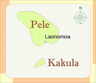
Kakula is a small uninhabited islet in Shefa Province of Vanuatu in the Pacific Ocean. The island is a tourist destination.


