
Torba is the northernmost and least populous province of Vanuatu. It consists of the Banks Islands and the Torres Islands.
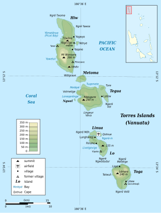
The Torres Islands are an island chain in the Torba Province of the country of Vanuatu, the country’s northernmost island group. The chain of islands that make up this micro-archipelago straddles the broader cultural boundary between Island Melanesia and several Polynesian outliers located in the neighbouring Solomon Islands. To the island chain’s north is Temotu Province of the Solomon Islands, to its south is Espiritu Santo, and to its southeast are the Banks Islands. To the west, beneath the ocean surface, is the deep Torres Trench, which is the subduction zone between the Australian Plate and Pacific Plate.

Gaua is the largest and second most populous of the Banks Islands in Torba Province in northern Vanuatu. It covers 342 km2.
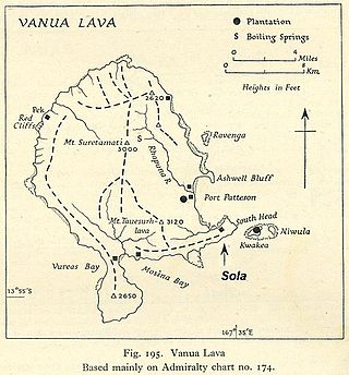
Vanua Lava is the second largest of the Banks Islands in Torba Province, Vanuatu, after slightly larger Gaua.
Tegua is an island in Vanuatu's Torres Islands chain, located in Torba Province.

Mota is an island in the Banks group of northern Vanuatu. Its population – today about 700 people – speak the Mota language, which Christian missionaries of the Anglican Church used as a lingua franca in parts of Melanesia.
Ureparapara is the third largest island in the Banks group of northern Vanuatu, after Gaua and Vanua Lava.

Aore is an island in Sanma Province, Vanuatu. It is located opposite Luganville on Espiritu Santo and has an area of 58 square kilometres (22 sq mi). The estimated terrain elevation above sea level is some 89 metres (292 ft).

Hiw is the northernmost island in Vanuatu, located in Torba Province.
Metoma is a small volcanic island in Torba Province of Vanuatu in the Pacific Ocean.
Lo-Toga is an Oceanic language spoken by about 580 people on the islands of Lo and Toga, in the Torres group of northern Vanuatu. The language has sometimes been called Loh [sic] or Toga, after either of its two dialects.
Lo is an island in the Torres group of islands, in northern Vanuatu. The island is located 2.25 miles from the Toga Island. As of 2009, the population of the island was 210. They speak the Lo dialect of the Lo-Toga language.
Hiw is an Oceanic language spoken on the island of Hiw, in the Torres Islands of Vanuatu. With about 280 speakers, Hiw is considered endangered.

Rah or Ra is a small coral islet of 0.5 km2 (0.19 sq mi), located in the Banks group of northern Vanuatu. The same name also refers to the single village which is situated within this islet.
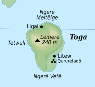
Toga is an island in the Torres group, within the Torba Province of Vanuatu.

Ravenga is a small island in Torba Province, Vanuatu, in the Pacific Ocean. The island is also known as Ranenger.
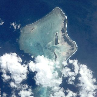
Rowa Islands are an uninhabited archipelago in Torba Province of Vanuatu in the Pacific Ocean. The Rowa are a part of larger Banks Islands archipelago. The islands are a natural border between Melanesia and Polynesia; they are one of the most beautiful places in the South Pacific Ocean and an integral part of a vast system of atolls and reefs.
Ngwel is an uninhabited island in Torba Province of Vanuatu in the Pacific Ocean. The island is a part of the Torres Islands archipelago.

Lamen is an inhabited island in Shefa Province of Vanuatu in the Pacific Ocean. The island is a part of Shepherd Islands archipelago.
The Torres–Banks languages form a linkage of Southern Oceanic languages spoken in the Torres Islands and Banks Islands of northern Vanuatu.

