Vanuatu, officially the Republic of Vanuatu, is an island country in Melanesia, located in the South Pacific Ocean. The archipelago, which is of volcanic origin, is 1,750 km (1,090 mi) east of northern Australia, 540 km (340 mi) northeast of New Caledonia, east of New Guinea, southeast of Solomon Islands, and west of Fiji.
Malampa is one of the six provinces of Vanuatu, located in the center of the country. It consists of three main islands: Malakula, Ambrym and Paama, and takes its name from the first syllable of their names. It includes a number of other islands – the small islands of Uripiv, Norsup, Rano, Wala, Atchin and Vao off the coast of Malakula, and the volcanic island of Lopevi. Also included are the Maskelynes Islands and some more small islands along the south coast of Malakula.

Penama is one of the six provinces of Vanuatu, located in the northeast of the country and consisting of three major islands:
Tafea is the southernmost of the six provinces of Vanuatu. The name is an acronym for the five main islands that make up the province: Tanna, Aneityum, Futuna, Erromango and Aniwa.

Aneityum is the southernmost island of Vanuatu, in the province of Tafea.

Malakula Island, also spelled Malekula, is the second-largest island in the nation of Vanuatu, formerly the New Hebrides, in Melanesia, a region of the Pacific Ocean.

Malo is an island in Vanuatu 3 km (1.9 mi) off the southern coast of Vanuatu's largest island, Espiritu Santo, in Sanma Province. It has a circumference of 55 km (34 mi) and an area of 180 km2 (69 sq mi). It is 17 kilometres or 11 miles long, and 13 kilometres or 8.1 miles across at its widest point. The highest point on the island is Mount Malo.

Paama is a small island in Malampa Province, Vanuatu.
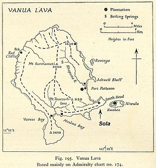
Vanua Lava is the second largest of the Banks Islands in Torba Province, Vanuatu, after slightly larger Gaua.
Bokissa is a very small island in the South Pacific island nation of Vanuatu located 10 km (6 mi) south of Espiritu Santo.
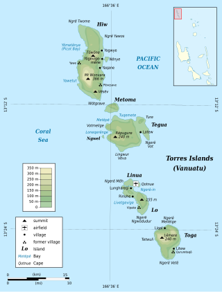
Tegua is an island in Vanuatu's Torres Islands chain, located in Torba Province.
Araki is a small rocky island with an area of 2.5 km², located 3 miles off the southern shores of Espiritu Santo, which is the largest island in the nation of Vanuatu.
Lo is an island in the Torres group of islands, in northern Vanuatu. The island is located 2.25 miles from the Toga Island. As of 2009, the population of the island was 210. They speak the Lo dialect of the Lo-Toga language.

Rah or Ra is a small coral islet of 0.5 km2 (0.19 sq mi), located in the Banks group of northern Vanuatu. The same name also refers to the single village which is situated within this islet.
Tomman Island is a small island just off the southwest coast of Malakula in Vanuatu in the Pacific Ocean.
Ahamb, also spelled Axamb or Akhamb is an Oceanic language spoken in South Malakula, Vanuatu.
Norsup is an island across the bay from the village with the same name on Malakula Island in Malampa Province, Vanuatu in the Pacific Ocean.
Atchin is an islet off the north-eastern coast of Malakula in Vanuatu. The 1999 census showed a population of 761, which had decreased to 738 by 2009. According to the 2015 census, the population had further decreased to 724, residing in 158 households.
Arseo Island is a small, uninhabited island in the Malampa Province of Vanuatu in the Pacific Ocean. The estimated terrain elevation above sea level is some 172 metres (564 ft). There are two small neighboring islands: Leumanang and Varo.


